- Thu. Mar 12th, 2026
Latest Post
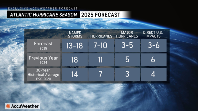 The 2025 hurricane season expected to be slightly above average!
 Camp Mystic Devastating Flooding, what can we learn from it?
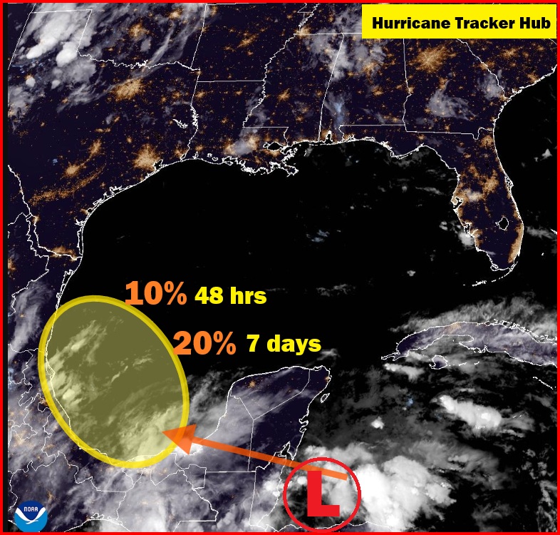 Tropical System in the Southwestern Gulf of America: An Evening Update from the National Hurricane Center
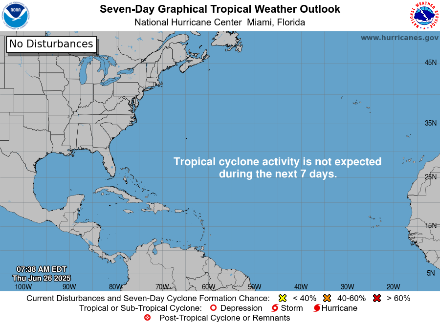 National Hurricane Center Tropical Outlook for June 26, 2025: Gulf of Mexico and Atlantic Region
NHC Tropical Update for June 26, 20252: What You Need to Know
National Hurricane Center Tropical Outlook for June 26, 2025: Gulf of Mexico and Atlantic Region
NHC Tropical Update for June 26, 20252: What You Need to Know
Florence Becoming More Of A Threat To The Southeastern US
Hello everyone! Florence remains a tropical storm this afternoon as it moves west though the Central Atlantic. The system has been struggling with dry air and wind shear over the…
Hurricane Florence: Long Range East Coast Threat?
Hello everyone! With Tropical Storm Gordon having made landfall and moved inland, our focus will now shift to the next storm in the Atlantic, Hurricane Florence. Florence is currently a…
Florida Weather Blog
Gulf Coast Weather Blog
Hurricane Blog
Mississippi Weather Blog
Pine Belt Weather Blog
Tropical Storm Gordon: A Little Stronger, Further East: Three Scenarios for the Central Gulf Coast
The center of Tropical Storm Gordon is emerging from a brief traversal of the southern tip of Florida. It is south of Everglades right now and will continue to pass…
Florida Weather Blog
Gulf Coast Weather Blog
Hurricane Blog
Mississippi Weather Blog
Pine Belt Weather Blog
Advisory for Potential Tropical Cyclone Seven Advisory Number 2 and Tropical Storm Florence
BULLETIN Potential Tropical Cyclone Seven Advisory Number 2 NWS National Hurricane Center Miami FL AL072018 1100 PM EDT Sun Sep 02 2018 …DISTURBANCE MOVING QUICKLY WEST-NORTHWESTWARD… …TROPICAL STORM CONDITIONS AND…
Florida Weather Blog
Gulf Coast Weather Blog
Hurricane Blog
Mississippi Weather Blog
Pine Belt Weather Blog
Tropical Wave To Move Into The Gulf Of Mexico This Week, Development Possible
by Jack Sillin/ 09/01/2018/ Hello everyone! A few days ago, I discussed the state of the tropical Atlantic, and why it was likely to become more active in the days…
Florida Weather Blog
Gulf Coast Weather Blog
Hurricane Blog
Mississippi Weather Blog
Pine Belt Weather Blog
[September 1st] Tropical Wave May Develop in Gulf of Mexico Next Week
https://www.youtube.com/watch?v=-5aXu2Aw7LQ
Florida Weather Blog
Gulf Coast Weather Blog
Hurricane Blog
Mississippi Weather Blog
Pine Belt Weather Blog
Tropical Update: Why Has It Been So Quiet In The Atlantic This Month?
Today’s update will come in two parts, this being part one, focusing on the tropical Atlantic. The season has gotten off to a slow start, but we’re only just entering…
Coastal Change Hazards: Hurricanes and Extreme Storms
Hurricane Katrina Before and After Photo Comparisons: Mainland Mississippi The mainland shoreline of Mississippi, located in the right-front quadrant of Hurricane Katrina, experienced one of the greatest storm surges in…
Florida Weather Blog
Gulf Coast Weather Blog
Hurricane Blog
Mississippi Weather Blog
Pine Belt Weather Blog
One Year after Hurricane Katrina’s Surge
We’re traveling the coastline destroyed by Hurricane Katrina’s record storm surge. This is something that has never been shown on the news or talked about, either in the overall, or…
Rebuilding New Orleans: Detailing a New Vernacular
13 years ago this month, Hurricane Katrina devastated New Orleans. During the years following the levee failures, the city witnessed a boom in architectural experimentation, as small, independent developers joined…
Florida Weather Blog
Gulf Coast Weather Blog
Hurricane Blog
Mississippi Weather Blog
Pine Belt Weather Blog
NOAA Makes Winter Weather Forecast for 2018-2019 Season
The new NOAA Winter Weather Forecast 2018-2019 is here. Summer may still be in full swing, but that doesn’t mean that colder weather isn’t on the way. The meteorologists at…
Florida Weather Blog
Gulf Coast Weather Blog
Hurricane Blog
Mississippi Weather Blog
Pine Belt Weather Blog
Chris moving Away from US – Will Impact Newfoundland Thursday and Early Friday
Tropical Storm Chris is beginning to move northeastward this morning, away from the United States. Since Chris sat in the same spot for a couple days, the water beneath the…
Florida Weather Blog
Gulf Coast Weather Blog
Hurricane Blog
Mississippi Weather Blog
Pine Belt Weather Blog
Chris Becomes a Hurricane East of the Carolinas
Above: Visible satellite image of Chris as of 20Z (4 pm EDT) Tuesday, July 10, 2018. Image credit: RAMMB / CIRA @ CSU. Tropical Storm Chris became the second hurricane…
Florida Weather Blog
Gulf Coast Weather Blog
Hurricane Blog
Mississippi Weather Blog
Pine Belt Weather Blog
Beryl Significantly Weaker as We Expected
Above: Visible satellite image of Beryl from 9 am EDT Saturday, July 7, 2018. Beryl’s circulation center was exposed to view, with just one clump of heavy thunderstorms on the…
Big Drop in CSU’s Atlantic Hurricane Outlook; Quiet Atlantic, Active Pacific
Above: Sea surface temperatures (SSTs) analyzed at 2 am EDT Tuesday, July 3, 2018, across the North Atlantic, as compared to the 1981-2010 average SST for this time of year,…
Florida Weather Blog
Gulf Coast Weather Blog
Hurricane Blog
Mississippi Weather Blog
Pine Belt Weather Blog
East Pacific Overachieving, Atlantic and Northwest Pacific Underwhelming
Above: Four systems in various stages of potential development were highlighted in the tropical weather outlook issued by the NOAA/NWS National Hurricane Center at 8 am EDT Monday, June 25,…
Florida Weather Blog
Gulf Coast Weather Blog
Hurricane Blog
Mississippi Weather Blog
Pine Belt Weather Blog
Meteorologists United on Climate Change
Above: West Palm Beach broadcast meteorologist Jeff Berardelli (CBS12) with the warming-stripes graphic being used in Thursday’s Meteorologists United on Climate Change campaign. Image credit: Courtesy Jeff Berardelli. Close to…
Florida Weather Blog
Gulf Coast Weather Blog
Hurricane Blog
Mississippi Weather Blog
Pine Belt Weather Blog
Five Years after El Reno, “The Man Who Caught the Storm” Is a Stunner
Above: In this file photo from May 26, 2006, in Ames, Iowa, Tim Samaras shows the probes he was using when trying to collect data from a tornado. Image credit:…
NOAA Predicts a Near-Normal or Above-Normal Atlantic Hurricane Season; Update on 90L
Above: The strongest Atlantic hurricane of 2017, Hurricane Irma, as seen by the MODIS instrument on September 5, 2017. At the time, Irma was at peak strength, a Category 5…
Florida Weather Blog
Gulf Coast Weather Blog
Hurricane Blog
Mississippi Weather Blog
Pine Belt Weather Blog
Tropical Weather Update 10 AM 5/23/2018
The National Hurricane Center currently has a 60 percent chance that the low will become a subtropical or tropical cyclone over the central or eastern Gulf over the next 5…