

EXTENDED RANGE FORECAST OF ATLANTIC SEASONAL HURRICANE
ACTIVITY AND LANDFALL STRIKE PROBABILITY FOR 2024
We anticipate that the 2024 Atlantic basin hurricane season will be extremely active. Current El Niño conditions are likely to transition to La Niña conditions this summer/fall, leading to hurricane-favorable wind shear conditions. Sea surface temperatures in the eastern and central Atlantic are currently at record warm levels and are anticipated to remain well above average for the upcoming hurricane season. A warmer-than-normal tropical Atlantic provides a more conducive dynamic and thermodynamic environment
for hurricane formation and intensification.
This forecast is of above-normal confidence for an early April outlook. We anticipate a well above-average probability for major hurricanes making landfall along the continental United States coastline and in the
Caribbean. As with all hurricane seasons, coastal residents are reminded that it only takes one hurricane making landfall to make it an active season. Thorough preparations should be made every season, regardless of predicted activity.
Information obtained through March indicates that the 2024 Atlantic hurricane season will have activity well above the 1991–2020 average. We estimate that 2024 will have 23 named storms (average is 14.4), 115 named storm days (average is 69.4), 11 hurricanes (average is 7.2), 45 hurricane days (average is 27.0), 5 major (Category 3-4-5) hurricanes (average is 3.2) and 13 major hurricane days (average is 7.4).
The probability of U.S. and Caribbean major hurricane landfall is estimated to be well above its longperiod average. We predict Atlantic basin Accumulated Cyclone Energy (ACE) and Net Tropical Cyclone (NTC) activity in 2024 to be approximately 170 percent of their longterm averages.
Coastal residents are reminded that it only takes one hurricane making landfall to make it an active season for them. Thorough preparations should be made for every season, regardless of how much activity is predicted.
This forecast is based on an extended-range early April statistical prediction scheme that was developed using ~40 years of past data. Analog predictors are utilized as well. We are also including statistical/dynamical models based off of 25–40 years of past data from the European Centre for Medium Range Weather Forecasts, the UK Met Office, the Japan Meteorological Agency and the Centro Euro-Mediterraneo sui Cambiamenti Climatici model as four additional forecast guidance tools.
This model guidance is unanimously pointing towards a hyperactive season. The tropical Pacific is currently characterized by El Niño conditions. These El Niño conditions are likely to transition to neutral ENSO conditions in the next few weeks and then to La Niña conditions by the peak of the Atlantic hurricane season. La Niña typically increases Atlantic hurricane activity through decreases in vertical wind shear.
This year’s sea surface temperatures in the eastern and central tropical Atlantic are much warmer than normal, also favoring an active Atlantic hurricane season via dynamic and thermodynamic conditions that are conducive to developing hurricanes.
The early April forecast is the earliest seasonal forecast issued by Colorado State University and has modest long-term skill when evaluated in hindcast mode. While the skill of this prediction is low, our confidence is higher than normal this year for an early April forecast given how hurricane-favorable the large-scale conditions appear to be. The skill of CSU’s forecast updates increases as the peak of the Atlantic hurricane season approaches. We also present probabilities of exceedance for hurricanes and Accumulated Cyclone Energy to give interested readers a better idea of the uncertainty associated with these forecasts.
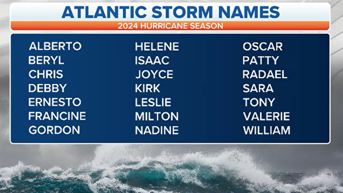
Hurricane season 2024 Atlantic basin tropical cyclone names
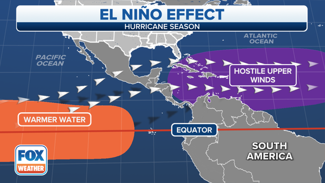
Significantly warmer water in the key equatorial belt typically correlates with limited hurricane development.
What the neutral status means for the 2024 season
An average Atlantic basin hurricane season produces 14 named storms, of which seven go on to become hurricanes and three normally reach major hurricane status with winds of at least 115 mph.
Seven of the last eight years have all finished with above-normal activity, including 2018 and 2023, when El Niño patterns were in control in the Pacific.
The 2024 season could be in a similar state to seasons such as 2016, 2010, 2003, 1998 and 1995, when significant El Niño events were on the decline ahead of the next La Niña stage.
A busy year does not correlate to high U.S. landfall impacts, but with more cyclone chances comes the possibility that more people could find themselves in a cone of concern.
Last year’s hurricane season was the least impactful for the U.S. in nearly a decade, so only a small uptick in activity can increase the threat level.
Features that forecasters will keep an eye on include the Saharan dust layer and water temperatures, which could dictate early-season activity.
Key outlooks for the 2024 hurricane season will begin to be released in April and May ahead of the season’s June 1 start.
