

SOUTH MISSISSIPPI WEATHER FORECAST:
Today and Tonight: Today will mark an end to the nice cooler and drier weather we experienced this past holiday weekend, and the start of a more summerlike warm and wet pattern. A brief period of foggy conditions is possible in the Pine Belt early this morning as moisture begins returning. Looking at early morning water vapor satellite imagery, the presence of an elongated trough can be seen stretching from the Great Lakes across much of the central and western CONUS toward the Baja Peninsula where an upper-level low is spinning.
On the eastern side of this trough, deeper moisture is streaming northeast across our region. An area of overnight convection in South and East Texas seems to be associated with what models have analyzed as a shortwave ejecting ahead of the main trough, and it is that shortwave should help to sustain and trigger new convection over northern Louisiana southern Arkansas by this afternoon. Modest CAPE (~1500 J/kg SBCAPE) and shear values (30 kts 0-6 km shear) will support some potentially strong to marginally severe storms over northeast Louisiana and southeast Arkansas through the early evening.
Locally heavy rain is also possible with some of these storms, however initial conditions are dry across the forecast area, so flash flooding threat is minimal at this time. These showers and storms will eventually outrun the best moisture and instability, but drier air farther east may support an increased damaging wind threat even into parts of western Mississippi heading into the evening. For now a Marginal Risk for severe thunderstorms has been added for our northeast LA parishes, far southeastern AR counties, and the western stack of counties in MS. Showers and a few thunderstorms will spread east across the rest of the forecast area tonight as the initial shortwave continues eastward.
Detailed Forecast
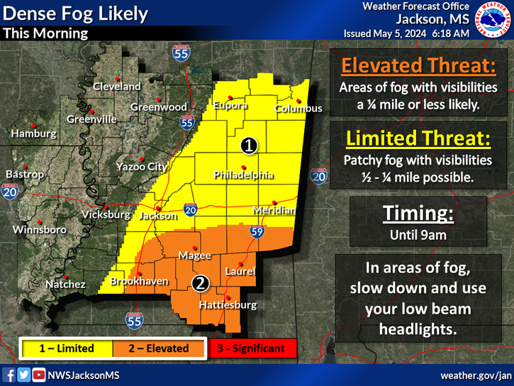
Today
Patchy dense fog before 8am. Otherwise, partly sunny, with a high near 88. Light and variable wind becoming south southeast 5 to 10 mph in the morning.
Tonight
A 20 percent chance of showers and thunderstorms. Cloudy, with a low around 68. South wind 5 to 10 mph becoming light after midnight.
Wednesday
A chance of showers before 1pm, then showers likely and possibly a thunderstorm between 1pm and 4pm, then showers and thunderstorms likely after 4pm. Mostly cloudy, with a high near 86. South wind 5 to 10 mph. Chance of precipitation is 60%. New rainfall amounts of less than a tenth of an inch, except higher amounts possible in thunderstorms.
Wednesday Night
Thunderstorms likely before 7pm, then a chance of showers and thunderstorms after 1am. Mostly cloudy, with a low around 68. South wind around 5 mph becoming calm after midnight. Chance of precipitation is 60%. New rainfall amounts of less than a tenth of an inch, except higher amounts possible in thunderstorms.
Thursday
A chance of showers before 10am, then a chance of showers and thunderstorms between 10am and 1pm, then showers likely after 1pm. Mostly cloudy, with a high near 84. Calm wind becoming south southwest around 5 mph in the morning. Chance of precipitation is 70%. New rainfall amounts between a quarter and half of an inch possible.