
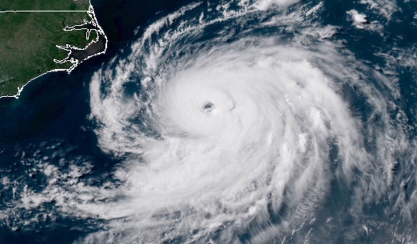
| Above: Visible satellite image of Chris as of 20Z (4 pm EDT) Tuesday, July 10, 2018. Image credit: RAMMB / CIRA @ CSU. |
Tropical Storm Chris became the second hurricane of the 2018 Atlantic season at 5 pm EDT Tuesday afternoon. Located about 200 miles east-southeast of Cape Hatteras, North Carolina, Chris was packing top sustained winds of 85 mph, according to the National Hurricane Center (NHC). Chris underwent a striking burst of intensification on Tuesday, giving every appearance of being a hurricane hours before that status became official. In a flight Tuesday afternoon, hurricane hunters found a central pressure of 980 mb, with flight-level winds as strong as 88 knots (101 mph). The stepped frequency microwave radiometer aboard the hurricane-hunter flight detected near-surface winds of 84 – 89 mph, which supports the NHC intensity estimate of 85 mph.
Chris is a well-organized hurricane with a clearly defined eye about 23 miles wide, a core of strong convection (showers and thunderstorms), and prominent bands of convection feeding into the core. The only thing missing on Tuesday morning was clear evidence of sustained surface winds of at least 74 mph, the minimum required for hurricane strength. For this reason, National Hurricane Center (NHC) held off on upgrading Chris in its 11 am forecast package, but acknowledged that an upgrade would likely occur later in the day (as it indeed did).
Chris’s langorous behavior amid weak steering currents kept it positioned well off the Southeast U.S. coast near the Gulf Stream over the weekend. Chris moved back and forth for days across a swath less than 150 miles long, and its location at 11 pm Monday was almost identical to that from 11 pm EDT Friday. When a tropical storm holds almost stationary for a day or more, it will typically churn up cooler waters that chip away at its strength. In this case, the Gulf Stream has been replenishing the warm waters directly beneath part of Chris’s circulation—though not all of it. A buoy (41002) located about 260 miles south of Cape Hatteras showed sea surface temperatures (SSTs) dropping from 79.3°F to 75.9°F from midday Monday to midday Tuesday. NHC hypothesized that storm-cooled waters may have worked to stabilize the lowest part of the atmosphere, which would tend to inhibit the strongest winds aloft from mixing completely to the surface.
 |
| Figure 1. Enhanced infrared satellite image of Chris as of 2022Z (4:22 pm EDT) Tuesday, July 10, 2018. Image credit: NASA/MSFC Earth Science Branch. |
A busier-than-expected Atlantic season so far
Chris became a tropical storm on July 8, more than a month earlier than the typical August 13 date for the appearance of the season’s third named storm, based on 1966-2009 climatology data from NHC. The first hurricane of the season typically forms on August 10, and the second on August 28, which compares to the formation of this year’s first hurricane, Beryl, on July 6 and Chris on July 10. It’s a bit surprising to see a season widely expected to be less active than usual off to such a busy start.
According to CSU hurricane scientist Phil Klotzbach, only three prior years in the satellite era (1966-present) have seen the Atlantic generate at least two hurricanes by July 10. Those years are 1966, 1968, and 2005. As a group, they don’t serve as especially useful harbingers of what to expect for the rest of this year, given that 2005 was a super-active season, 1966 was active, and 1968 was very quiet.
Forecast for Chris
Chris began its long-awaited trek to the northeast late Monday night, and its pace picked up on Tuesday with the approach of a seasonally strong upper-level trough. As of 5 pm EDT Tuesday, Chris was moving northeast at about 10 mph, taking it away from the U.S. coast. Given the approach of the upper-level trough, we can expect Chris to continue accelerating northeastward on a track well north of Bermuda. By Thursday, Chris is expected to be transitioning to post-tropical cyclone status as it races toward a potential landfall Thursday night across southern Newfoundland.
Despite its fairly high latitude for a hurricane (33°N), Chris may intensify even more over the next day or so. Since Chris will be moving more quickly in tandem with the increased upper-level flow, there won’t be any initial detriment to the storm. The vertical wind shear is predicted by the 12Z Tuesday run of the SHIPS model to hold fairly steady—in the moderate range (10-15 knots)—into Wednesday, and the upper-level jet just north of Chris may provide an outflow channel to nourish the storm for a time. Sea-surface temperatures (SSTs) beneath Chris’s path will be near or just above the minimum benchmark for tropical development of 26°C (79°F) through Wednesday, but Chris’s impressive structure could help make up for the lack of toasty water.
 |
| Figure 2. The starting-point analysis for the 06Z Tuesday run of the HWRF model, showing surface pressures (millibars) and sea-surface temperatures (SSTs, in degrees C). Chris can be seen as a 997-millibar low positioned above SSTs that are close to 26°C (79°F), considered the minimum benchmark for tropical development. The SSTs beneath Chris’s path will not dip significantly below 26°C until late Wednesday. Image credit: tropicaltidbits.com, with a shout-out going to Hank Dolce (@tropicaltopics), who used this map in a tweet on Tuesday. |
NHC predicted in its 5 pm Tuesday forecast package that Chris’s sustained winds will peak early Wednesday at 100 mph, or Category 2 strength, before gradually weakening as wind shear increases and Chris encounters much cooler water. Our top intensity models—the HWRF, DSHIPS, and LGEM—predicted on Tuesday morning that Chris would reach peak intensity on Thursday morning, with maximum sustained winds of 85 to 90 mph, Category 1 on the Saffir-Simpson scale. Given Chris’s impressive strengthening on Tuesday, these model forecasts may be a bit conservative, and it’s entirely possible that Chris will reach Category 2 strength, as now predicted by NHC. Even a brief surge to major hurricane status (Category 3) can’t be completely ruled out. If such a quick leap does occur on Tuesday night, we might not know for sure, as the hurricane-hunter flight for Tuesday night has been cancelled given that Chris is moving away from the U.S. coast.
One thing we can predict with high confidence is that Chris’s impact on the U.S. East Coast will be relatively minor. There were no storm-related watches or warnings along the immediate mid-Atlantic coast late Tuesday, other than small craft advisories and warnings for high rip currents in some areas. High swells can be expected over the next several days as Chris plows across the northwest Atlantic.