
 ACCURATE FIRST WEATHER — TROPICAL UPDATE
With Meteorologist Louis Smith
 Thursday, May 14, 2026
The tropics are beginning to slowly wake up as we move closer to the official start of the 2026 Atlantic Hurricane Season on June 1st.
At this time, there are NO active tropical cyclones anywhere in the Atlantic Basin, but the National Hurricane Center continues monitoring tropical waves, increasing thunderstorm activity, and early-season tropical moisture across the Atlantic.
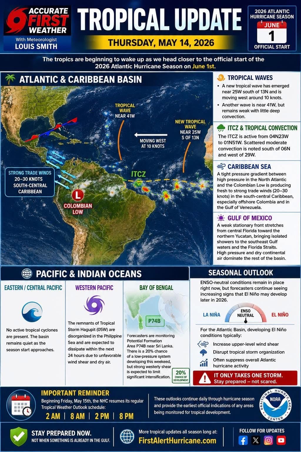
 ATLANTIC & CARIBBEAN BASIN
Tropical Waves
• A new tropical wave has emerged in the far eastern Atlantic near 25°W south of 13°N and is moving west around 10 knots.
• Another tropical wave is located farther west near 41°W but remains weak with little organized thunderstorm activity.
 ITCZ & Tropical Convection
The Intertropical Convergence Zone (ITCZ) remains active across portions of the tropical Atlantic with scattered moderate convection south of 6°N west of 29°W. This is typical for mid-May and signals increasing tropical moisture across the basin.
 Caribbean Sea
Strong easterly trade winds continue across the south-central Caribbean, especially near Colombia and the Gulf of Venezuela, where winds of 20–30 knots are occurring due to the tight pressure gradient between Atlantic high pressure and the Colombian Low.
 Gulf of Mexico
The Gulf remains quiet for now.
A weak stationary front stretches from central Florida toward the northern Yucatán Peninsula, bringing isolated showers across portions of the southeast Gulf and Florida Straits. Elsewhere, dry air and high pressure continue dominating much of the Gulf.
 PACIFIC & INDIAN OCEAN UPDATE
Pacific Basin
• No tropical cyclones are currently active in the Eastern or Central Pacific as the season startup approaches.
Western Pacific
• The remnants of former Tropical Storm Hagupit continue weakening in the Philippine Sea and are expected to dissipate soon due to hostile wind shear and dry air intrusion.
Bay of Bengal
• Forecasters continue monitoring Potential Formation Area P74B near Sri Lanka, although development chances remain low due to strong upper-level wind shear limiting organization.
 SEASONAL OUTLOOK
ENSO-neutral conditions remain in place for now, but forecasters continue seeing increasing signs that El Niño may develop later in 2026.
For the Atlantic Basin, developing El Niño conditions typically:
• Increase upper-level wind shear
• Disrupt tropical storm organization
• Often suppress overall Atlantic hurricane activity
 But remember Gulf Coast residents:
It only takes ONE storm.
Even during quieter hurricane seasons, dangerous “homegrown” systems can still rapidly develop close to land.
 IMPORTANT REMINDER
Beginning Friday, May 15th, the National Hurricane Center resumes its regular Tropical Weather Outlook schedule:
 2 AM
2 AM
 8 AM
8 AM
2 PM
8 PM
These outlooks provide the earliest official signs of any areas being monitored for tropical development.
Stay prepared NOW — not when something is already in the Gulf.
More tropical updates all season long at:
 FirstAlertHurricane.com