THE “GULF MONSOON” IS BREAKING UP: A MAJOR PATTERN SHIFT IS UNDERWAY
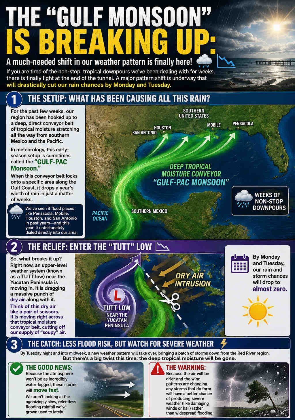
If you’re tired of the seemingly endless tropical downpours we’ve experienced over the past several weeks, there is finally some good news. A significant change in the weather pattern is developing that will dramatically reduce rain chances by Monday and Tuesday.
Here’s what’s happening and what it means for the Gulf Coast:
 WHAT HAS BEEN CAUSING ALL THE RAIN?
• For weeks, our region has been connected to a deep conveyor belt of tropical moisture stretching from the eastern Pacific and southern Mexico into the Gulf Coast.
• This setup is sometimes referred to as a Gulf-Pacific moisture connection, which funnels enormous amounts of tropical moisture into one area for extended periods.
• When this pattern locks into place, it can produce excessive rainfall, flash flooding, and saturated ground conditions for weeks at a time.
• Similar patterns have contributed to major flooding events in places such as Houston, Mobile, Pensacola, and San Antonio in previous years.
WHAT IS CHANGING?
• An upper-level weather feature known as a TUTT (Tropical Upper Tropospheric Trough) Low is moving near the Yucatán Peninsula.
• This system is pulling a large area of much drier air into the Gulf region.
• Think of it as a pair of scissors cutting through the tropical moisture pipeline that has been feeding our storms.
• As this dry air spreads northward, rain and thunderstorm coverage will rapidly decrease.
• By Monday and Tuesday, many areas could see little to no rainfall.
THE GOOD NEWS
 Rain chances drop significantly.
Flooding concerns decrease substantially.
More sunshine and fewer tropical downpours.
Rivers, streams, and saturated soils finally get an opportunity to recover.
THE TRADE-OFF
 By Tuesday night and into midweek, a different storm pattern may develop as thunderstorms move southward from the Red River region.
Unlike recent weeks, these storms will not have access to the deep tropical moisture that fueled widespread flooding.
Storms should move faster, reducing the risk of prolonged heavy rainfall.
However, changing wind patterns and slightly drier air may allow some storms to become stronger, with damaging wind gusts and hail becoming a greater concern than flooding.
BOTTOM LINE
The early-summer tropical deluge is finally beginning to lose its grip on the Gulf Coast. Expect a much-needed break from the daily tropical downpours early this week, followed by a transition to a more typical summertime pattern.
We’ll continue monitoring the midweek storm potential and provide updates as confidence increases.