
 ACCURATE FIRST WEATHER — 72 HOUR RAINFALL TOTALS
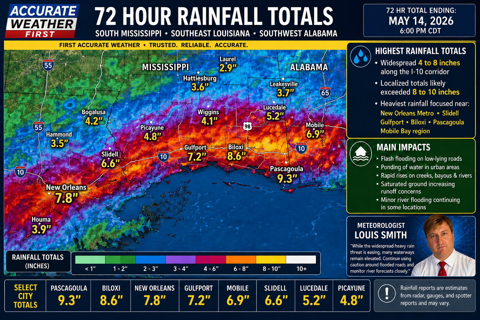
With Meteorologist Louis Smith
A very impressive swath of rainfall was recorded across portions of Southeast Louisiana, South Mississippi, and Southwest Alabama over the past 72 hours. The heaviest rain axis stretched from the New Orleans metro eastward along the Gulf Coast into coastal Mississippi and the western Florida Panhandle.
 Highest Rainfall Totals
 Highest Rainfall Totals
- Widespread 4 to 8 inches of rain fell along the I-10 corridor
- Localized totals likely exceeded 8 to 10 inches in isolated spots
- Heaviest rainfall focused near:
- New Orleans Metro
- Slidell
- Gulfport
- Biloxi
- Pascagoula
- Mobile Bay region
Main Impacts
 Main Impacts
- Flash flooding on low-lying roads
- Ponding of water in urban areas
- Rapid rises on creeks, bayous, and rivers
- Saturated ground increasing runoff concerns
- Minor river flooding continuing in some locations
South Mississippi Overview
 South Mississippi Overview
South Mississippi saw a solid corridor of heavy tropical-style rainfall, especially south of Highway 98. Some communities experienced multiple rounds of thunderstorms training over the same areas, leading to significant rainfall accumulation totals.
Southeast Louisiana
 Southeast Louisiana
The New Orleans metro and surrounding parishes were hit particularly hard with persistent heavy rain bands moving west to east along the coast.
Southwest Alabama
Coastal Alabama and areas near Mobile also picked up substantial rainfall totals, with some localized flooding issues reported.
Meteorologist Louis Smith
 Meteorologist Louis Smith
“While the widespread heavy rain threat is easing, many waterways remain elevated. Continue using caution around flooded roads and monitor river forecasts closely.”