

A swath of rain and a couple of embedded thunderstorms will continue to push north across the area into this evening. Much of the rainfall amounts with this will be on the lighter side but some heavier downpours will be possible. The inherited limited risk for flash flooding in the Pine Belt will be kept for this evening. While the bulk of the rain looks like it has moved through, I cannot rule out a few more showers or isolated thunderstorms moving north over that region.
South Mississippi will remain under persistent southwest flow aloft, which should help bring in several disturbances this week. Another swath of rain should move across the region on Sunday, but looks like mostly the western parts of the forecast area may be affected. This comes as a mid-level trough digs across west Texas and begins to swing across the Lone Star State. Cloudy conditions should keep temperatures overnight from dropping too much with lows forecast to be in the lower 40s in the Delta to the upper 40s/near 50 in the Pine Belt.
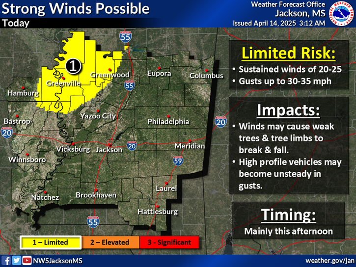
Sunday night through Friday night…A very wet extended forecast is on tap for South Mississippi. A warm front will push over and then north of the area Sunday night into Monday morning. Showers and at least some isolated thunderstorms will be on the increase overnight, especially across the delta. A shortwave and associated cold front will approach the area Monday morning and sweep across the area during the late morning through the afternoon hours. The models continue to indicate modest instability, but strong deep layer shear though, as the line of storms moves across the area. The SPC has the Pine Belt under a marginal risk for severe weather. WIth a tight surface gradient out ahead of the boundary, the winds will be pretty strong. Expect gusts into at least the mid 20 mph range across most of the Pine Belt, with gusts from 30-35mph across the delta during the late morning/early afternoon hours. The bulk of the thunderstorm activity will move east by the late afternoon/early evening hours, but showers could hang on in the southeast through Monday night, as the boundary stalls just southeast of the area.
Tuesday looks mostly dry and cool across the area as surface high pressure briefly builds in. Increasing isentropic lift and moisture will combine for more light rain moving north over the area Tuesday night into Wednesday morning. Beyond Wednesday the GFS/ECMWF diverge in their solutions with the GFS being much more suppressed with next system than the ECMWF. Will lean towards the ECMWF since it has been a little more consistent. Both of the models cut-off a low, but the ECMWF tracks the mid-level low much further to the north across Arkansas into the Ohio Valley. The result is the potential for another round of heavy rainfall Wednesday into Thursday with a surface low tracking across the area. This system will shift east of the area Thursday night into Friday morning with Surface high-pressure building in on Friday.
Here is your Extended Forecast for the Hattiesburg Area.

Futurecast Radar (HRRR)

I will have an update around mid-night Tonight.
Jason Scott