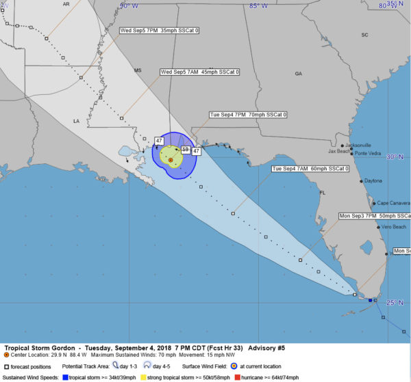
The center of Tropical Storm Gordon is emerging from a brief traversal of the southern tip of Florida. It is south of Everglades right now and will continue to pass south of Naples as it heads out into the southeastern Gulf of Mexico. It is headed WNW at 16 mph at this time.
Top winds are 45 mph. The Air Force Reserve Hurricane Hunter plane found 41 mph surface winds on the SFMR instrument. The plane also found a large area of flight level winds greater than 40 knots well to the northwest of the center.
Winds have calmed considerably over the Keys now. In fact, they are calm at Marathon and NNE at 4 mph at Key West.
Satellite imagery indicates that the convection associated with Gordon continues to increase and this trend should continue as the storm moves over the open waters of the southeastern Gulf. Gordon will gradually strengthen and the official forecast now makes it a 70 mph tropical storm just south of the Alabama coast Tuesday evening. Gordon could become a hurricane before landfall.
The official track now carries it to the Mississippi coast around 10 p.m. Tuesday evening. We caution everyone now to focus on the center line of the forecast but to remember that the center could make landfall anywhere from Pensacola to the Mouth of the Mississippi River This would of course greatly change the forecast impacts along the Gulf Coast.
The tropical storm warning has been shifted eastward to include Escambia, Santa Rosa and Okaloosa counties in Northwest Florida, including Pensacola, Pensacola Beach,Navarre, For Walton and Destin.
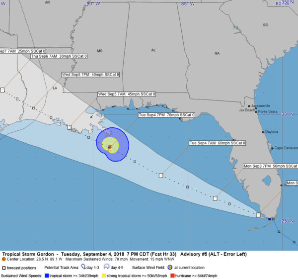
Let’s compare the forecast wind impacts based on three scenarios:

Official track, 7 p.m. Tuesday showing tropial storm and strong troipcal storm force winds affecting Alabama coast
SCENARIO 1 – CENTER OF FORECAST TRACK
Under this scenario, the center would cross the coast near Biloxi around 11 p.m. Tuesday evening. Tropical storm force winds would begin to be felt on Dauphin Island and along the Baldwin County Coast by 3-4 p.m. Strong tropical storm force winds would reach Dauphin Island around 6 p.m. Tropical storm force winds would reach Bilxo around 6-7 p.m. and increase to strong tropical storm force between 8 pm and midnight, peaking around 67 mph. Heavy rain would cause flooding across coastal Alabama and southern Mississippi and there would be a 2-4 foot storm surge near and to the right of where the center makes landfall, affecting the eastern part of the Mississippi coast as well as all of the Alabama coast into the Fort Walton/Destin areas.
SCENARIO 2 – RIGHT SIDE OF FORECAST TRACK
Under this scenario, the landfall would come around 5 p.m. Tuesday near Pensacola Beach. Tropical storm force winds would be felt all along the Northwest Florida coast, starting around 10 a.m. tomorrow near Panama City and gradually spreading westward along the coast, reaching the 30A communities and Destin around noon, and Fort Walton and Pensacola during the early afternoon. Strong tropical storm force winds (greater than 58 mph would affect Fort Walton, Navarre, Pensacola Beach and perhaps Orange Beach. through the late afternoon hours extending up into eastern Baldwin County and southwestern Alabama’s Washington, Clarke, Monroe, and Escambia Counties. The city of Mobile would experience a brief period of tropical storm force winds. Rainfall will be heavy and there will be a storm surge of 2-4 along the Northwest Florida coast der this scenario.

A more westerly track lessens impacts for Alabama and Northwest Florida with no tropical storm force winds felt.
SCENARIO 3 – LEFT SIDE OF FORECAST TRACK
Under this scenario, the center of Gordon would pass south of the Mouth of the Mississippi River around 7 p.m. Tuesday and make landfall early Wednesday morning, around 5 a.m., near Morgan City. In this scenario, the southern Louisiana Parishes around Grand Isle, Houma, and Morgan City would experience tropical storm conditions, but the New Orleans, Mississippi Coastal, Alabama Coastal and Northwest Florida coastal areas would escape them. Rainfall would be heavy and a 2-4 foot storm surge would still impact coastal Alabama and Mississippi.
STRONGER THAN ALBERTO
Gordon will be stronger than Subtropical Storm Alberto which made landfall near Laguna Beach, Florida, near Panama City, on Memorial Day. Alberto had top winds of 50 mph and it caused plenty of havoc in the Panama City area.
COULD GORDON BECOME A HURRICANE?
Lots of warm water to traverse an increasingly favorable upper air conditions mean that Gordon does have the chance to become stronger and perhaps reach hurricane intensity, which would increase these wind and surge forecasts.
HURRICANE WATCH ISSUED FOR MISSISSIPPI/ALABAMA COAST:
A hurricane watch has been posted from the mouth of the Pearl River to the Alabama/Florida border.
REMEMBER DENNIS?
Hurricane Dennis made landfall near Navarre Beach in July 2005 with top winds of 130 mph. It caused significant tree damage well up into South Alabama. Dennis was much stronger than Gordon is expected to be, but if Gordon strengthens more than expected, impacts oculd be greater.

