


BULLETIN
Potential Tropical Cyclone Seven Advisory Number 2 NWS National Hurricane Center Miami FL AL072018 1100 PM EDT Sun Sep 02 2018
…DISTURBANCE MOVING QUICKLY WEST-NORTHWESTWARD… …TROPICAL STORM CONDITIONS AND HEAVY RAINFALL POSSIBLE OVER PORTIONS OF THE CENTRAL GULF COAST TUESDAY NIGHT AND WEDNESDAY… SUMMARY OF 1100 PM EDT…0300 UTC
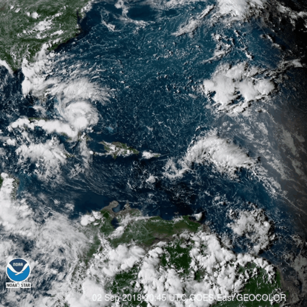
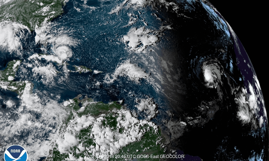
INFORMATION — LOCATION…23.4N 78.7W ABOUT 175 MI…285 KM ESE OF MARATHON FLORIDA MAXIMUM SUSTAINED WINDS…30 MPH…45 KM/H PRESENT MOVEMENT…WNW OR 300 DEGREES AT 15 MPH…24 KM/H MINIMUM CENTRAL PRESSURE…1012 MB…29.89 INCHES
WATCHES AND WARNINGS — CHANGES WITH THIS ADVISORY: A Storm Surge Watch has been issued for the north-central Gulf coast from the Mississippi-Alabama border westward to the Mouth of the Mississippi River.

SUMMARY OF WATCHES AND WARNINGS IN EFFECT: A Storm Surge Watch is in effect for… * Mississippi-Alabama border westward to the Mouth of the Mississippi River A Tropical Storm Watch is in effect for… * Alabama-Florida border westward to east of Morgan City, Louisiana, including Lake Pontchartrain and Lake Maurepas Interests in the Florida Keys and the southern Florida peninsula should monitor the progress of this system. For storm information specific to your area, including possible inland watches and warnings, please monitor products issued by your local National Weather Service forecast office.
DISCUSSION AND OUTLOOK ———————- At 1100 PM EDT (0300 UTC), the disturbance was centered near latitude 23.4 North, longitude 78.7 West. The system is moving toward the west-northwest near 15 mph (24 km/h), and this general motion is expected to continue through Wednesday. On the forecast track, the disturbance will pass over the Florida Keys or the southern portion of the Florida peninsula Monday, and move over the southeastern Gulf of Mexico by Monday evening, and reach the central Gulf Coast by late Tuesday or Tuesday night. Maximum sustained winds are near 30 mph (45 km/h) with higher gusts. Gradual strengthening is forecast during the next 48 hours, and the disturbance is forecast to become a tropical storm Monday night. Conditions appear to be conducive for development, and this system is expected to become a tropical cyclone by Monday night. * Formation chance through 48 hours…high…80 percent * Formation chance through 5 days…high…80 percent The estimated minimum central pressure is 1012 mb (29.89 inches).
HAZARDS AFFECTING LAND –STORM SURGE: The combination of a dangerous storm surge and the tide will cause normally dry areas near the coast to be flooded by rising waters moving inland from the shoreline. The water could reach the following heights above ground somewhere in the indicated areas if the peak surge occurs at the time of high tide… Destin Florida to the Mississippi-Alabama border…1 to 2 ft. Mississippi-Alabama border to the Mouth of Mississippi River…2 to 4 ft Mouth of the Mississippi River to the Louisiana-Texas border…1 to 2 ft. The deepest water will occur along the immediate coast near and to the east of the landfall location, where the surge will be accompanied by large waves. Surge-related flooding depends on the relative timing of the surge and the tidal cycle, and can vary greatly over short distances. For information specific to your area, please see products issued by your local National Weather Service forecast office.
RAINFALL: The disturbance is expected to produce total rain accumulations of 2 to 4 inches over the central and northwestern Bahamas, the Florida Keys, and South Florida through early Tuesday. Isolated maximum amounts of 8 inches are possible over the southern Florida peninsula. This rainfall may cause flooding. The disturbance is expected to produce heavy rainfall along the central Gulf Coast of the United States by the middle of the week.

WIND: Tropical storm conditions are possible within the watch area by late Tuesday. Tropical-storm-force wind gusts will be possible Monday across portions of South Florida and the Florida Keys.


Potential Tropical Cyclone Seven Discussion Number 2
NWS National Hurricane Center Miami FL AL072018 1100 PM EDT Sun Sep 02 2018 There has been little change in the organization of the disturbance since the previous advisory. Satellite imagery shows that some new convective bands have formed to the northeast of the trough axis, but there is still no evidence of a closed surface circulation at this time. The initial intensity remains 25 kt, which is in agreement with the earlier ASCAT data and recent surface observations. An Air Force Reserve Unit reconnaissance aircraft is scheduled to investigate the disturbance on Monday to give a better assessment of the structure and intensity of the system. The disturbance will be moving over warm waters and within an area of generally low vertical wind shear. These conditions should allow gradual development of the system over the next day or so. The global model guidance indicates that the surface trough will sharpen and that a closed surface circulation is likely to develop in association with the system over the Gulf of Mexico within the next 24-36 hours.
Once this occurs, the system is expected to continue to gradually strengthen until it reaches the north-central Gulf coast Tuesday night or early Wednesday. The intensity guidance did not change much this cycle and neither has the latest official forecast. The initial motion estimate is 300/13 kt. The disturbance is forecast to move west-northwestward to northwestward around the southwestern portion of a deep-layer ridge that is centered over the Mid-Atlantic states. On this heading, the disturbance is expected to pass over the Florida Keys or the southern Florida peninsula tomorrow morning, then cross the eastern Gulf of Mexico Monday night before approaching the north-central Gulf coast late Tuesday or Tuesday night. The dynamical model guidance is in good agreement on this scenario, however, since the system is still in the pre-genesis phase future changes regarding the exact track and timing of the onset of hazards are possible. Key Messages:
1. Potential Tropical Cyclone Seven will bring heavy rainfall and gusty winds to portions of the Bahamas, South Florida, and the Florida Keys tonight and Monday, and interests in those areas should monitor the progress of this system. 2. A Tropical Storm Watch has been issued for portions of the central Gulf Coast, and tropical storm conditions are possible in those areas Tuesday night and Wednesday. Heavy rainfall from this system will affect portions of the central Gulf Coast later this week, including areas that are currently receiving heavy rainfall from a different weather system. Interests in these areas should monitor products from their local National Weather Service office. 3. Users should be aware that forecast uncertainty for potential tropical cyclones is generally larger than that for tropical cyclones, especially beyond 48-72 hours.


Tropical Cyclone Seven Local Statement Advisory Number 1
National Weather Service New Orleans LA AL072018
502 PM CDT Sun Sep 2 2018
This product covers Southeast Louisiana and South Mississippi
***TROPICAL STORM WATCH NOW IN EFFECT***
NEW INFORMATION
—————
* CHANGES TO WATCHES AND WARNINGS:
– A Tropical Storm Watch has been issued for Ascension,
Assumption, East Baton Rouge, Hancock, Harrison, Iberville,
Jackson, Livingston, Lower Jefferson, Lower Lafourche, Lower
Plaquemines, Lower St. Bernard, Lower Terrebonne, Orleans,
Southern Tangipahoa, St. Charles, St. James, St. John The
Baptist, St. Tammany, Upper Jefferson, Upper Lafourche, Upper
Plaquemines, Upper St. Bernard, Upper Terrebonne, and West
Baton Rouge
* CURRENT WATCHES AND WARNINGS:
– A Tropical Storm Watch is in effect for Ascension, Assumption,
East Baton Rouge, Hancock, Harrison, Iberville, Jackson,
Livingston, Lower Jefferson, Lower Lafourche, Lower
Plaquemines, Lower St. Bernard, Lower Terrebonne, Orleans,
Southern Tangipahoa, St. Charles, St. James, St. John The
Baptist, St. Tammany, Upper Jefferson, Upper Lafourche, Upper
Plaquemines, Upper St. Bernard, Upper Terrebonne, and West
Baton Rouge
* STORM INFORMATION:
– About 940 miles east-southeast of New Orleans LA or about 900
miles east-southeast of Gulfport MS
– 22.7N 77.3W
– Storm Intensity 30 mph
– Movement West-northwest or 300 degrees at 15 mph
POTENTIAL IMPACTS
—————–

Event:Hurricane Local Statement- Alabama
Alert:
This product covers portions of southwest Alabama…northwest Florida…south central Alabama…and inland southeast Mississippi.
**TROPICAL STORM CONDITIONS AND HEAVY RAINFALL POSSIBLE OVER PORTIONS OF THE CENTRAL GULF COAST TUESDAY NIGHT AND WEDNESDAY** NEW INFORMATION —
* CHANGES TO WATCHES AND WARNINGS: – A Tropical Storm Watch has been issued for Baldwin Central, Baldwin Coastal, Mobile Central, and Mobile Coastal * CURRENT WATCHES AND WARNINGS: – A Tropical Storm Watch is in effect for Baldwin Central, Baldwin Coastal, Mobile Central, and Mobile Coastal * STORM INFORMATION: – About 860 miles southeast of Mobile AL or about 810 miles southeast of Pensacola FL – 22.7N 77.3W – Storm Intensity 30 mph – Movement West-northwest or 300 degrees at 15 mph
SITUATION OVERVIEW —
A potential Tropical Cyclone forming across the southern Bahamas is forecast to move into the southeast Gulf of Mexico Monday afternoon. This system will continue moving west-northwest around 15 mph, and track toward the southeast Louisiana coast Monday night through Tuesday. This system will have the potential to bring significant rainfall amounts and flash flooding to the area, mainly across inland southeast Mississippi, southwest Alabama, and the western Florida panhandle. Tropical storm force winds and coastal flooding remain possible, and additional information will be provided in future advisories.
POTENTIAL IMPACTS —
* FLOODING RAIN: Prepare for locally hazardous rainfall flooding having possible limited impacts across portions of southwest Alabama…northwest Florida…south central Alabama…and inland southeast Mississippi.. Potential impacts include: – Localized rainfall flooding may prompt a few evacuations. – Rivers and tributaries may quickly rise with swifter currents. Small streams, creeks, canals, and ditches may become swollen and overflow in spots. – Flood waters can enter a few structures, especially in usually vulnerable spots. A few places where rapid ponding of water occurs at underpasses, low-lying spots, and poor drainage areas. Several storm drains and retention ponds become near-full and begin to overflow. Some brief road and bridge closures.
* SURGE: Not available at this time. To be updated this evening.
* WIND: Little to no impacts are anticipated at this time across portions of southwest Alabama…northwest Florida…south central Alabama…and inland southeast Mississippi..
* TORNADOES: Little to no impacts are anticipated at this time across portions of southwest Alabama…northwest Florida…south central Alabama…and inland southeast Mississippi..
PRECAUTIONARY/PREPAREDNESS ACTIONS —
* EVACUATIONS: Listen to local official for recommended preparedness actions, including possible evacuation. If ordered to evacuate, do so immediately. Assess the risk from wind, falling trees, and flooding at your location. If you decide to move, relocate to a safer location nearby. If you do not relocate, help keep roadways open for those under evacuation orders.
* OTHER PREPAREDNESS INFORMATION: Now is the time to check your emergency plan and emergency supplies kit and take necessary actions to protect your family and secure your home or business. When making safety and preparedness decisions, do not focus on the exact forecast track since hazards such as flooding rain, damaging wind gusts, storm surge, and tornadoes extend well away from the center of the storm. If in a place that is vulnerable to high wind, such as near large trees, a manufactured home, upper floors of a high-rise building, or on a boat, plan to move to safe shelter. If you live in a place particularly vulnerable to flooding, such as near the ocean or a large inland lake, in a low-lying or poor drainage area, in a valley, or near an already swollen river, plan to move to safe shelter on higher ground. Always heed the advice of local officials and comply with orders that are issued. Do not needlessly jeopardize your life or the lives of others. When securing your property, outside preparations should be concluded as soon as possible before conditions deteriorate. The onset of strong gusty winds or flooding can cause certain preparedness activities to become unsafe. Be sure to let friends and family members know of your intentions for weathering the storm and your whereabouts. Have someone located away from the threatened area serve as your point of contact. Share vital contact information with others. Keep cell phones handy and charged. Check on those who may not be fully aware of the situation or who are unable to make personal preparations. If you are a visitor, know the name of the county or parish in which you are located and where it is relative to current watches and warnings. If staying at a hotel, ask the management staff about their onsite disaster plan. Listen for evacuation orders, especially pertaining to area visitors. Closely monitor weather.gov, NOAA Weather Radio and local news outlets for official storm information. Listen for possible changes to the forecast.
* ADDITIONAL SOURCES OF INFORMATION: – For the latest detailed evacuation and shelter information…please refer to your local emergency management agency at the phone number or website listed below. – Coastal Alabama: – Baldwin County: 251-972-6807 or
www.baldwincountyal.gov/departments/EMA – Mobile County: 251-460-8000 or www.mcema.net – Northwest Florida: – Escambia County: 850-471-6400 or bereadyescambia.com – Santa Rosa County: 850-983-5360 www.santarosa.fl.gov/emergency – Okaloosa County: 850-651-7150 or www.co.okaloosa.fl.us/ps/home – For information on appropriate preparations see ready.gov – For additional disaster preparedness information see redcross.org
NEXT UPDATE ———– The next local statement will be issued by the National Weather Service in Mobile AL around 10 AM CDT, or sooner if conditions warrant.
Target Areas:
Baldwin Central
Baldwin Coastal
Baldwin Inland
Butler
Choctaw
Clarke
Conecuh
Covington
Crenshaw
Escambia
Mobile Central
Mobile Coastal
Mobile Inland
Monroe
Washington
Wilcox
For Mississippi
Hurricane Local Statement
Alert:
This product covers portions of southwest Alabama…northwest Florida…south central Alabama…and inland southeast Mississippi.
**TROPICAL STORM CONDITIONS AND HEAVY RAINFALL POSSIBLE OVER PORTIONS OF THE CENTRAL GULF COAST TUESDAY NIGHT AND WEDNESDAY** NEW INFORMATION —————
* CHANGES TO WATCHES AND WARNINGS: – A Tropical Storm Watch has been issued for Baldwin Central, Baldwin Coastal, Mobile Central, and Mobile Coastal
* CURRENT WATCHES AND WARNINGS: – A Tropical Storm Watch is in effect for Baldwin Central, Baldwin Coastal, Mobile Central, and Mobile Coastal * STORM INFORMATION: – About 860 miles southeast of Mobile AL or about 810 miles southeast of Pensacola FL – 22.7N 77.3W – Storm Intensity 30 mph – Movement West-northwest or 300 degrees at 15 mph
SITUATION OVERVIEW —————— A potential Tropical Cyclone forming across the southern Bahamas is forecast to move into the southeast Gulf of Mexico Monday afternoon. This system will continue moving west-northwest around 15 mph, and track toward the southeast Louisiana coast Monday night through Tuesday. This system will have the potential to bring significant rainfall amounts and flash flooding to the area, mainly across inland southeast Mississippi, southwest Alabama, and the western Florida panhandle. Tropical storm force winds and coastal flooding remain possible, and additional information will be provided in future advisories.
POTENTIAL IMPACTS —————– * FLOODING RAIN: Prepare for locally hazardous rainfall flooding having possible limited impacts across portions of southwest Alabama…northwest Florida…south central Alabama…and inland southeast Mississippi.. Potential impacts include: – Localized rainfall flooding may prompt a few evacuations. – Rivers and tributaries may quickly rise with swifter currents. Small streams, creeks, canals, and ditches may become swollen and overflow in spots. – Flood waters can enter a few structures, especially in usually vulnerable spots. A few places where rapid ponding of water occurs at underpasses, low-lying spots, and poor drainage areas. Several storm drains and retention ponds become near-full and begin to overflow. Some brief road and bridge closures.
* SURGE: Not available at this time. To be updated this evening.
* WIND: Little to no impacts are anticipated at this time across portions of southwest Alabama…northwest Florida…south central Alabama…and inland southeast Mississippi..
* TORNADOES: Little to no impacts are anticipated at this time across portions of southwest Alabama…northwest Florida…south central Alabama…and inland southeast Mississippi.. PRECAUTIONARY/PREPAREDNESS ACTIONS
* ADDITIONAL SOURCES OF INFORMATION: – For the latest detailed evacuation and shelter information…please refer to your local emergency management agency at the phone number or website listed below. – Coastal Alabama: – Baldwin County: 251-972-6807 or www.baldwincountyal.gov/departments/EMA – Mobile County: 251-460-8000 or www.mcema.net – Northwest Florida: – Escambia County: 850-471-6400 or bereadyescambia.com – Santa Rosa County: 850-983-5360 www.santarosa.fl.gov/emergency – Okaloosa County: 850-651-7150 or www.co.okaloosa.fl.us/ps/home – For information on appropriate preparations see ready.gov – For additional disaster preparedness information see redcross.org
NEXT UPDATE ———– The next local statement will be issued by the National Weather Service in Mobile AL around 10 AM CDT, or sooner if conditions warrant.
Target Areas:
George
Greene
Perry
Stone
Wayne
…COASTAL FLOOD ADVISORY NOW IN EFFECT UNTIL 7 AM CDT TUESDAY…
St. Tammany-Livingston-St. John The Baptist-St. Charles-
Upper Jefferson-Orleans-Upper St. Bernard-Lower Plaquemines-
Lower St. Bernard-Southern Tangipahoa-Hancock-
529 PM CDT Sun Sep 2 2018
* COASTAL FLOODING…1 to 2 feet above normal tides with higher
levels expected by late Tuesday or Tuesday night.
* TIMING…through Monday night, but conditions will likely
deteriorate by late Tuesday into Tuesday night.
* IMPACTS…Minor inundation of low lying areas along the coast
and outside levees during high tide.
Coastal Hazard Message National Weather Service New Orleans LA 529 PM CDT Sun Sep 2 2018
…MINOR COASTAL FLOODING POSSIBLE DURING HIGH TIDE… .
With days of onshore flow, water levels have been slowly rising along the south and east facing shores and inside Lake Pontchartrain and Lake Maurepas. Tides of 1 to 2 feet above normal are expected to persist through at least Monday night, then higher tide levels are expected late Tuesday and Tuesday night. Minor inundation will be possible in the lower lying areas outside of levees during high tide through Monday night then more substantial coastal flooding will be possible by late Tuesday and Tuesday night when a warning will likely be required.
St. Tammany-Livingston-St. John The Baptist-St. Charles- Upper Jefferson-Orleans-Upper St. Bernard-Lower Plaquemines- Lower St. Bernard-Southern Tangipahoa-Hancock- 529 PM CDT Sun Sep 2 2018 …
COASTAL FLOOD ADVISORY NOW IN EFFECT UNTIL 7 AM CDT TUESDAY…
* COASTAL FLOODING…1 to 2 feet above normal tides with higher levels expected by late Tuesday or Tuesday night. * TIMING…through Monday night, but conditions will likely deteriorate by late Tuesday into Tuesday night. * IMPACTS…Minor inundation of low lying areas along the coast and outside levees during high tide.
BULLETIN
Tropical Storm Florence Advisory Number 15 NWS National Hurricane Center Miami FL AL062018 1100 PM AST Sun Sep 02 2018 …FLORENCE CONTINUES TO HOLD STEADY IN STRENGTH OVER THE EASTERN ATLANTIC… SUMMARY OF 1100 PM AST…0300 UTC
INFORMATION –LOCATION…17.9N 35.9W ABOUT 790 MI…1275 KM WNW OF THE SOUTHERNMOST CABO VERDE ISLANDS MAXIMUM SUSTAINED WINDS…50 MPH…85 KM/H PRESENT MOVEMENT…WNW OR 290 DEGREES AT 16 MPH…26 KM/H MINIMUM CENTRAL PRESSURE…1000 MB…29.53


INCHES WATCHES AND WARNINGS — There are no coastal watches or warnings in effect. DISCUSSION AND OUTLOOK –At 1100 PM AST (0300 UTC), the center of Tropical Storm Florence was located near latitude 17.9 North, longitude 35.9 West. Florence is moving toward the west-northwest near 16 mph (26 km/h). A slightly slower west to west-northwest motion is expected during the next few days. Maximum sustained winds remain near 50 mph (85 km/h) with higher gusts. Little change in strength is forecast during the next few days. Tropical-storm-force winds extend outward up to 60 miles (95 km) from the center. The estimated minimum central pressure is 1000 mb (29.53 inches).