
Hello everyone!
With Tropical Storm Gordon having made landfall and moved inland, our focus will now shift to the next storm in the Atlantic, Hurricane Florence. Florence is currently a Category three hurricane, with winds of 115 mph as of the 8 AM EDT advisory. The storm is moving NW this morning but is expected to make a turn to the west tomorrow. As of this writing, Florence does not pose a significant landfall risk, though that is an outcome that can’t be ruled out. Know what you’d do if Florence’s track were to include the East Coast, and be ready to put that plan into action if needed. The storm poses enough of a threat to pay attention, but certainly not enough to be overly concerned at this point.

A look at Florence on satellite imagery this morning shows a storm that’s struggling with dry air and wind shear. The system’s shower and thunderstorm activity is displaced to the northeast of the center, with sunny skies just SW of the core. The system continues to show good outflow to the north and east, which is a sign that Florence is unlikely to completely fall apart over the next couple days, even as the shear and dry air weakens it.
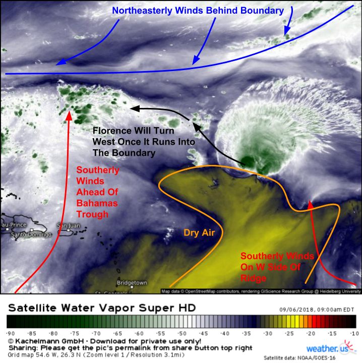
You can use GOES-16 water vapor satellite loops to get a sense for upper-level steering patterns because most of the features that show up here are right around the 400-500 MB level. Looped imagery shows that the wavy boundary north of Florence is separating southerly flow aloft (to the south of the boundary) from northerly/northeasterly flow aloft (north of the boundary). This boundary will act like a lid of sorts on Florence’s movement, making sure it can’t gain too much latitude in the next day or two. Expect a west turn tonight/tomorrow as Florence runs into this boundary.
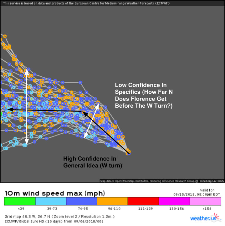
While we have high confidence in the general idea of this west turn (notice that all the EPS members have it), we have low confidence in how much latitude Florence gains before it turns west (notice the spread in EPS solutions). Any latitude gain in the next 24 hours increases the likelihood of recurvature once the storm gets closer to the East Coast, so it will be important to watch (which is easy to do with satellite imagery!) over the next 24 hours to see how far north the storm can make it.
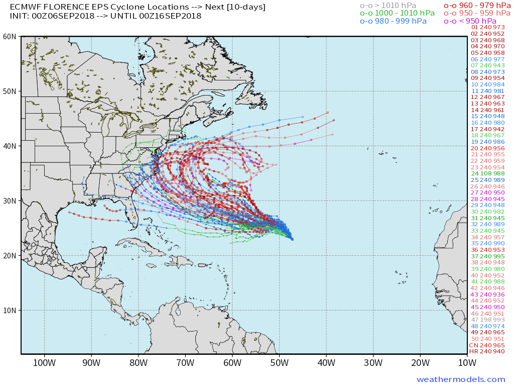
Florence’s long-range forecast remains spectacularly uncertain. EPS solutions range from the Gulf of Mexico to North Carolina to recurve hundreds of miles offshore. There are many moving parts with this forecast, many of which I’ve mentioned on Twitter. Before digging too much into those moving parts, which would influence the track of the hurricane in the 3-7 day period, I’m going to wait for the west turn to happen. Exactly where that turn happens will set the stage for the next part of the discussion, and too much speculation past that isn’t helpful.
Residents of the East Coast from Florida to Maine should know that impacts from Florence are possible, albeit far from a guarantee. We’ll have more confidence in the storm’s eventual track this weekend after the west turn has happened, and once some large scale players sort themselves out over North America. Be prepared for potential impacts, and know what you’d do if five days from now the forecast is for the storm to hit your area. Know if you might need to evacuate, and if so, where you would go as well as how long it would take you to get there. Even if Florence does end up recurving, at least by thinking about some of these things, you’ll be better prepared for the next storm, whether that be a few weeks or a few years from now.