
While the cold air developing in the arctic is impressive, it may have some side effects. Depending on where the cold air plunges, there will be two compensating ridges (that’s an oversimplification, as the ridges and troughs influence each other).
Here is the 500 mb forecast for the last two runs of the GFS for 00z December 24. The 06z:
.png)
The 00z:
.png)
The ECMWF:
.png)
Both models have a strong ridge in the Southeast. Amazingly, the 594 dm heights are not too far off from the summertime’s version of the Bermuda High. If this actually happens, we could be talking 60s and 70s in the Mid-Atlantic and Southeast on Christmas Eve.
In the other ocean, the GFS develops a textbook Omega Block (which looks like the Greek letter omega). Based on the high’s position in the Gulf of Alaska, this would have a tendency to bring a negatively tilted trough to the northwest of Hawaii and a positively tilted trough into the Southwest. So the model is consistent there. You can see this on the hemispheric view:
.png)
Now check out yesterday’s 18z run of the GFS. It had this for snowfall in the Southeast!
.png)
The upper air pattern for the time closest to the maps above shows that the Omega Block is close, but the high isn’t strong enough to bring the block together.
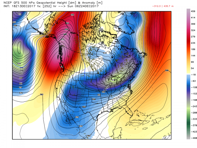
That allows the trough to take on a more neutral tilt and push the cold off to the east.
So the models are flipping and flopping in the longer term. Where the cold goes is actually all about the ridge positions. In model land there is high uncertainty to say the least. Whether this actually happens is a coin flip at this range, but our analogs (along with CPC’s), Phases 7-8 of the MJO and a strongly negative EPO strongly suggest this cold air gets put down in the central to eastern U.S. rather than the Southwest. Don’t be surprised if tomorrow the models are back in the cold camp.