
I usually focus on near-term weather threats here, but today with generally quiet weather across the US I want to look a little farther out into the medium-long range to show off some of the tools we have to forecast on the subseasonal timescale. About a week from now, we’ll be watching a potential winter storm that could impact parts of the Southeast and Mid Atlantic. The exact details of who might see wintry precip and how much remain uncertain, but that system is likely to usher in some warmer air for the Eastern half of the country during the middle of December. So what’s behind these long range changes? Let’s dig in.
Current Pattern/Upcoming Winter Storm Potential
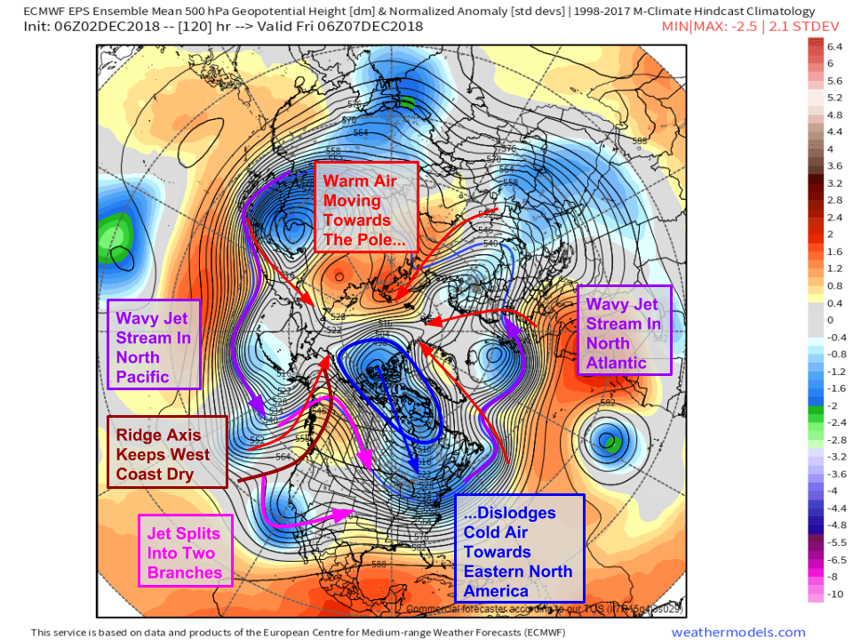
Here’s a look at the pattern over the Northern Hemisphere as it’s forecast to exist five days from now. It may look noisy at first, but the map above really boils down to a few key features. First, there are lots of storms across the Northern Hemisphere. One near the UK, one in the Gulf of Alaska, one off of Newfoundland, and one near Japan. These storms generate southerly winds on their eastern flanks, which move warm air northward towards the poles. As the warm air moves north, cold air gets dislodged and is forced to move south. An area of high pressure over Siberia is preventing the cold air from really moving south over Asia, so it’s forced to do so in the only other area where warm water won’t impede its progress: North America. Ridging along the Rockies prevents the cold air from moving south over the western part of the continent, so it’s easy to see how eastern North America is the only place left for the cold to go.
As for the storm, note the “split flow” pattern over the West Coast where the northern and southern branches of the jet stream split. The southern branch of the jet will send a disturbance through the Southern Rockies Friday, before emerging in Texas on Saturday.
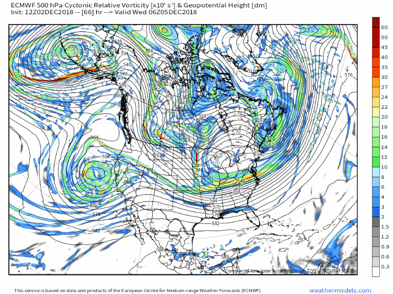
This animation of energy in the upper levels shows that disturbance, which will bring rain and mountain snow to California earlier in the week. There are still some challenges for model guidance to resolve with regards to this system, especially revolving around the speed of that disturbance’s ejection towards the Plains. However, probably the biggest challenge will be in the northern stream. Notice all the little disturbances moving through Canada as part of the northern stream. Exactly how these disturbances interact with the southern stream disturbance will determine what impacts can be expected from the storm.
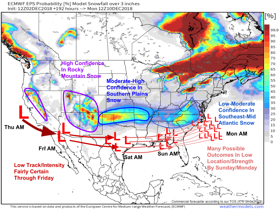 Here’s a look at the odds for reasonably significant (>3″) snow as this system travels across the southern tier of the country. Confidence is high in the first part of the storm’s evolution, as a Pacific low drops SE just off the California Coast. This will bring rain and mountain snow to California, and later the southern Rockies on Thursday/Friday. There’s moderate confidence in the next part of the storm’s evolution, as it moves through Texas. Snow is likely on the north side of the system during this time, but exactly which part of the southern Plains is most favored for snow, and exactly how much will fall, remains uncertain. The third part of the storm’s evolution, late next weekend into early the following week, is very uncertain. Depending on exactly what the southern disturbance looks like by the time it makes it to the NE Gulf of Mexico, and what disturbances in the northern stream are doing, significant snow is possible for parts of the Southeast/Mid Atlantic, but the storm could just as easily produce rain if the ingredients don’t come together just right.
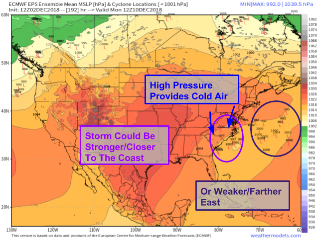
As the storm hits the East Coast, it’s likely to move too far south to bring the Northeast a blockbuster snowstorm, but as this EPS ensemble graphic shows, there is still a fairly wide range of outcomes for parts of the Carolinas and Virginia. A storm stronger and closer to the coast could produce significant snow, while a weaker system that’s farther east would be much less impactful. We’ll continue to monitor this system in the coming days!
Mid Month Pattern Flip
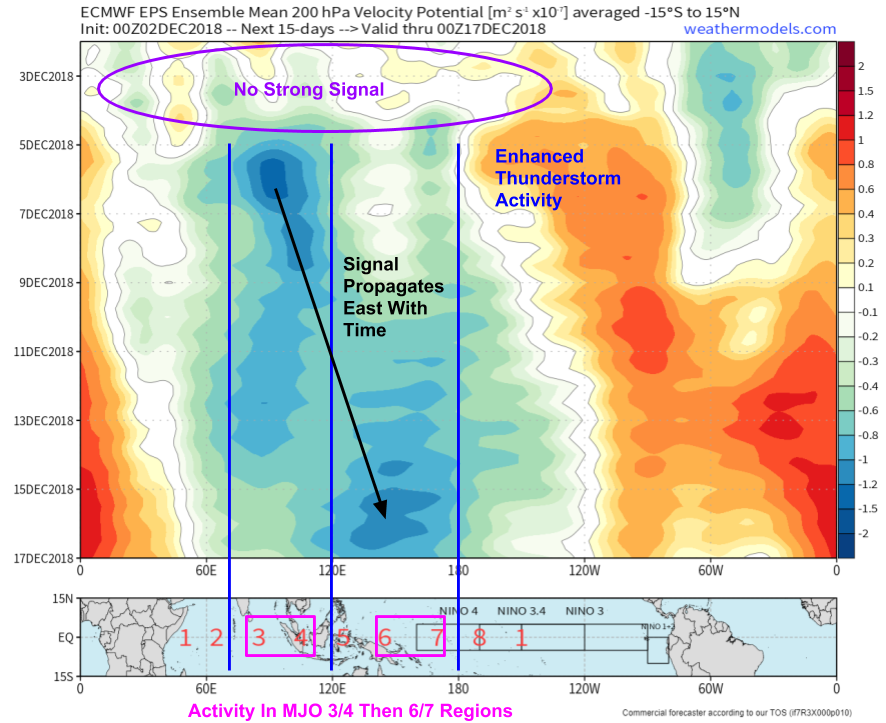
This chart shows areas of enhanced upward motion (more thunderstorms) and downward motion (fewer thunderstorms) in various parts of the tropics over the next 15 days. The seeds of the upcoming pattern change are reflected in this map, as enhanced tropical thunderstorm activity develops first over the eastern Indian Ocean and then moves across the Maritime Continent towards the western Pacific. So what does that have to do with our pattern here in the US?
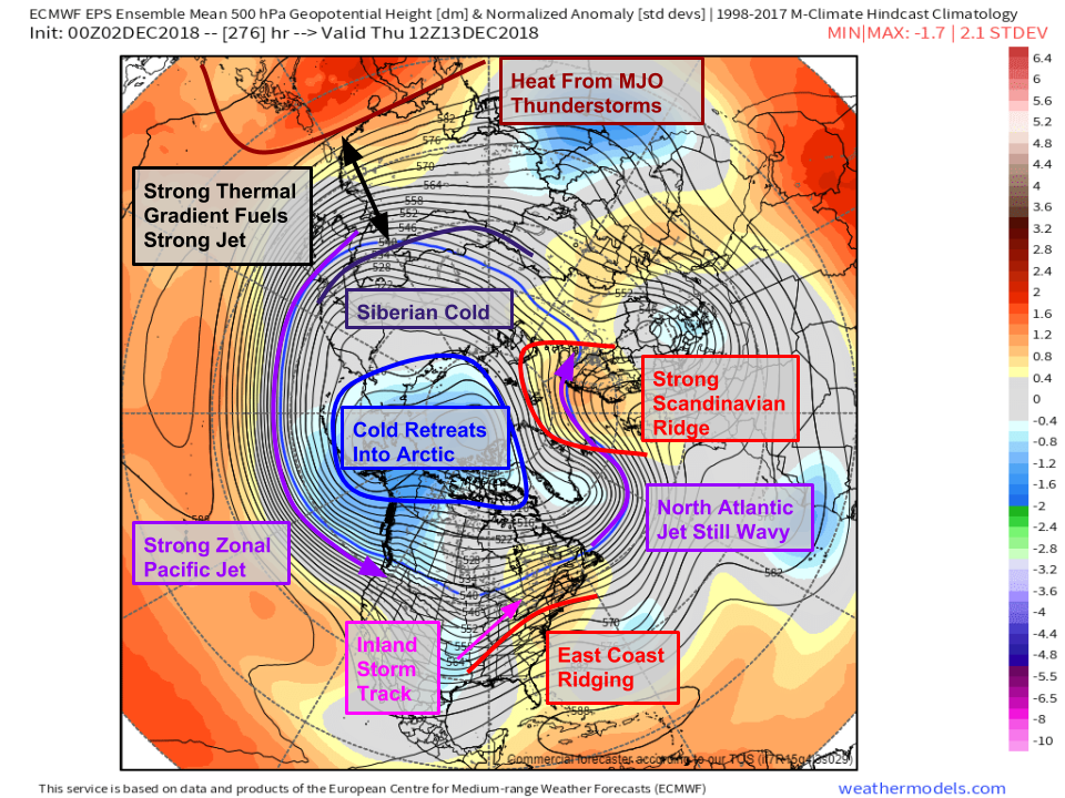
As the thunderstorms develop and release heat energy into the upper atmosphere, over Eastern Asia, the thermal gradient between the tropics (now extra warm from the thunderstorms) and Siberia (cold, because it’s Siberia) will strengthen. A stronger thermal gradient results in a stronger jet stream. That stronger jet has more zonal momentum that will “smooth out” the waves in the jet stream currently seen over the northern Pacific. When the strong jet hits North America, it still has its zonal momentum, which means that it continues moving along a more or less zonal (west-east) trajectory through the continent. As a result, we end up flooded with mild air from the Pacific, and the deep cold retreats back into the Arctic. Additionally, changes in the Atlantic pattern favor ridging along the East Coast, meaning not only will the cold air be locked away to the north, but also that we’ll have warm SW flow from the Gulf of Mexico, further enhancing prospects for warm temps.
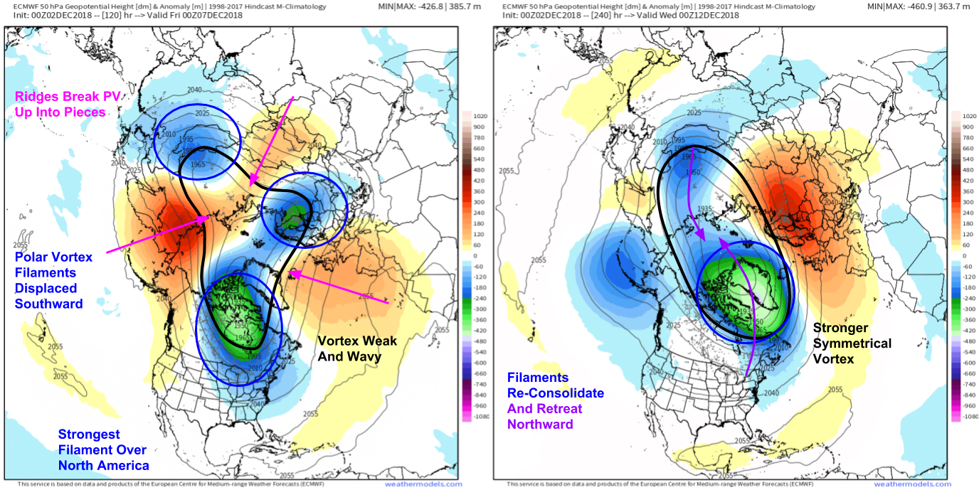
Another player in the warm change is the Polar Vortex. Yes, the Polar Vortex is an actual term for an actual atmospheric phenomenon! It’s too far up in the atmosphere (about 20,000 meters or 65,000 feet) to impact us directly, but it does indirectly shape our weather patterns. Note that when we’re watching for the storm this weekend, the vortex is weak with many filaments displaced to the south of the Arctic region. The most prominent filament happens to be located over North America, and will be supplying the cold air that makes next weekend’s storm threat potentially wintry for lower latitudes. However, as we move towards the middle of the month, the vortex appears to reconsolidate over the pole, taking the cold air with it. The stronger the vortex is, the more it can keep the cold air contained in higher latitudes.
So how long will the warm pattern last? That has yet to be determined, but it’s hard to get a very warm pattern to lock in for more than a week or two, so my guess would be that cooler and stormier conditions return to the East around or maybe a little before the new year.