
Here’s a look at our main system currently as it moves SE just off of Los Angeles. The storm has been quite impactful in California, causing heavy rain and mudslides in some of the burn scars near the LA area. Rains will taper off in California as the system shifts east tonight. Meanwhile, rain and snow will develop over parts of the southern Rockies. Higher elevations will pick up some solid accumulations, but no major widespread issues are anticipated. A deep plume of tropical moisture is noted across NW Mexico, streaming towards Texas, where the storm’s next major impacts will arrive tomorrow.
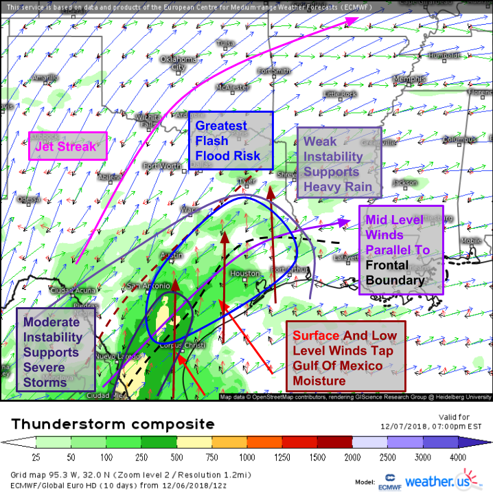
Here’s a look at the environment in Texas tomorrow evening as the storm emerges from the Southern Rockies. A surface boundary (the seeds of the surface low-pressure area) will be draped along the coastal plain, with a rich supply of Gulf moisture flowing north on its eastern flank. That boundary will be located much farther west at around 5,000 feet, with tropical moisture making into the Austin-Tyler corridor. With a strong jet streak located to the northwest and some marginal instability, heavy rain is going to be a big concern in SE Texas tomorrow. Note that mid-level winds are oriented parallel to the frontal boundary. This means that we’ll have to watch for “training” thunderstorms that drop heavy rains over the same areas repeatedly.
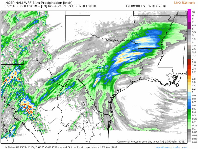
The NAM 3km model highlights this potential with over 6″ of rain possible along the front’s axis which will likely be located between Houston and Dallas. The Houston area will be at risk for flash flooding not necessarily from the front itself, but more from the cells that develop in the moist inflow towards the front, which could also train in persistent N-S oriented bands. Even outside the jackpot zones right along the front, a widespread 2-5″ of rain is expected for much of eastern/southern Texas which will cause minor river rises. Low lying areas near small streams should also watch out for inundation even in areas not forecast to see the highest totals.
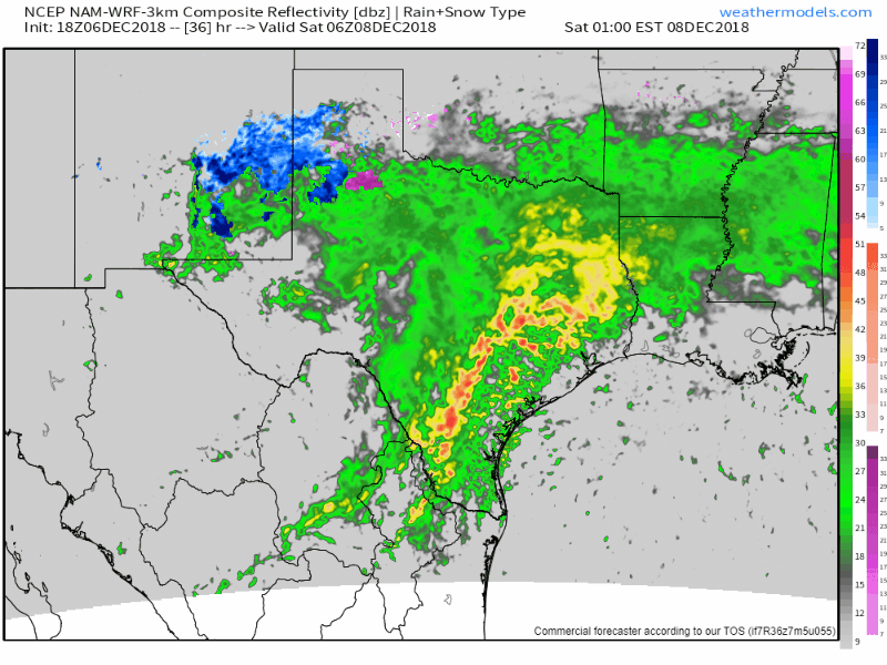
Strong winds aloft will combine with some instability (also visible on the thunderstorm composite map above) to support a marginal severe weather threat along the TX coast tomorrow. The main threat will be damaging winds. Finally, as the storm begins to move east towards LA, snow will develop to the north of the low in the Texas Panhandle as well as parts of Oklahoma. This will be the first phase of the wintry impacts from this system, which I’ll focus on for the rest of the post.
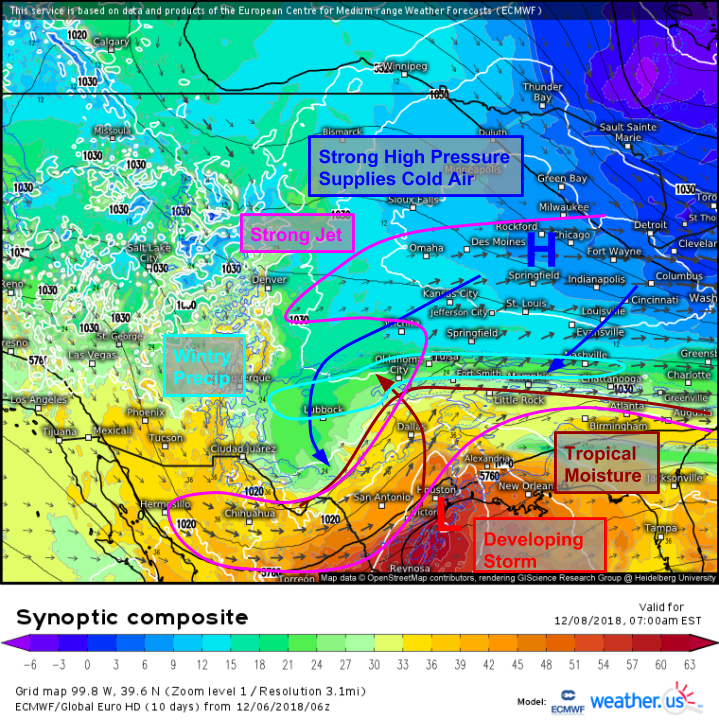
By Saturday, the synoptic environment will become favorable for wintry precip from the Texas Panhandle through the Ozarks into parts of the southern Ohio Valley. Strong Canadian high pressure is noted over the Midwest, with cold air draining southwest from its center. Meanwhile, tropical moisture will be drawn NW by a low-level jet associated with upper-level jet streaks over Texas (left entrance region of the cyclonically curved jet is located over Oklahoma) and the Central Plains (right entrance region of the anticyclonically curved jet is also found over OK). The combination of cold air, lifting, and moisture will result in snow beginning Saturday morning.
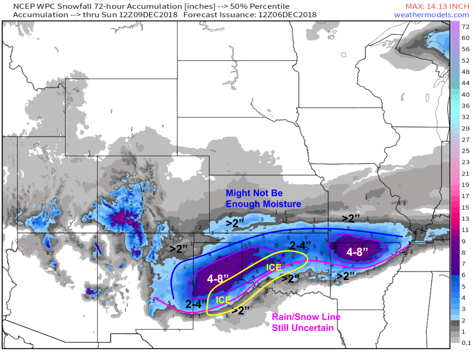
Here’s a rough idea of how much snow to expect from this system in the Southern Plains/Ozarks. Two bullseye areas are noted in NW AR and the TX Panhandle. Some uncertainty exists with regards to the northwestern extent of the steady precip due to potentially limited moisture. Uncertainty is also noted regarding the rain/snow line in southern Oklahoma and northern Texas. Along the rain/snow transition zone, freezing rain will bring hazards associated with ice accretion. Thankfully the setup isn’t quite right for a major icing event, but it only takes a thin glaze to make any exposed surfaces extremely slick!
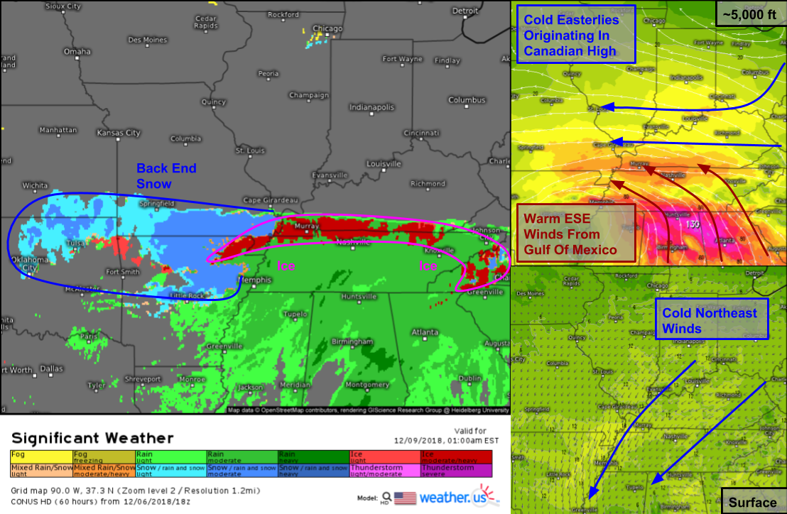
As the storm progresses east Saturday night, cold air will continue to flow south near the surface while warm air pushes in aloft. At the very northern edge of the precipitation shield along the KY-TN border, there will be enough warm air aloft, cold air at the surface, and moisture to see freezing rain. The band of freezing rain might be only 30-40 miles wide, but where it does set up, roads and sidewalks will become extremely slippery. As with the ice set up in OK/TX, this doesn’t appear to be significant enough to cause major power outage issues, but some scattered outages can’t be ruled out.

Sunday morning will mark the beginning of the main event for the Mid Atlantic/Southeastern states. A classic overrunning setup will be present as strong mid-level winds push warm air from the Gulf of Mexico up a low-level cold dome. This lifting will generate precipitation, which will cool the atmosphere as it falls into low-level dry air supplied by the high-pressure system to the north. This “evaporational cooling” is caused by the transfer of latent heat from the air to the snowflakes as they sublimate from solid phase ice crystals to gas phase water vapor, and it will briefly cool the column enough for flakes all the way down to the coast. ENE winds off the Gulf Stream will quickly warm the coast above freezing, with a prompt change to rain expected. Farther inland, cold air damming will lock in subfreezing air near the surface even as warm air tries to work in aloft. The result will be a battleground near Charlotte NC/Greenville SC where precipitation will likely be falling as either freezing rain or sleet depending on the depth of the warm layer.
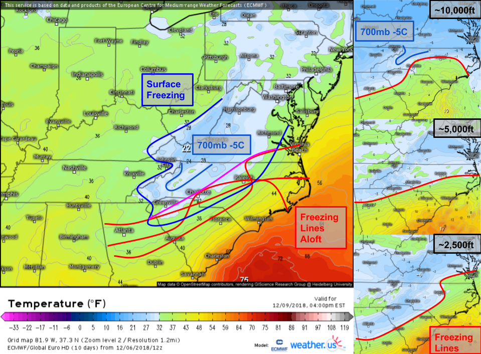 This graphic uses the temperature maps we have available for different levels in the atmosphere to piece together a 3-D picture of what’s going on above the Mid Atlantic on Sunday afternoon. Models always underestimate low-level cold air in cold air damming setups, so I’ve drawn the 32F line southeast of Raleigh/Charlotte even though the model predicts temps above that. I’ve also overlayed onto the surface temp map the 32F contours at various heights of 2,500 ft, 5,000 ft, and 10,000 ft. As you can see, the most likely zone for sleet (2,500 ft level is well below freezing, so sleet is more likely than freezing rain) is east of Greenville/Charlotte/Greensboro.
One last line I penciled in was the -5C contour at 700mb (10,000 ft). Why is this important? Warm air near the 700mb level inhibits the production of the classic six-sided snowflakes we’re all familiar with. When snowflakes can’t grow properly, they can’t accumulate efficiently, and thus the snow: liquid ratio is reduced, and you end up with heavier/wetter snow. This will likely be a consideration for SW NC, as only a very small area is currently forecast to hold onto those cooler temps aloft. Keep in mind, even -5C isn’t very cold in the grand scheme of things, it’s just cool enough to prevent total sludge from taking over.
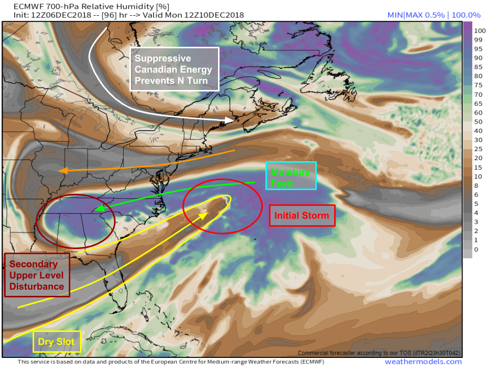
By Monday, we’ll be looking at an extremely interesting synoptic setup as our initial storm shoots well east off the coast, while a secondary upper-level disturbance attempts to keep the snow going. The stringing out of the system is due to a disturbance in SE Canada, the importance of which was discussed in depth yesterday. As the storm gets strung out, a dry slot will cut off the direct moisture connection to the Gulf of Mexico, but an indirect moisture feed from the Atlantic will remain intact. Depending on exactly how that secondary feature evolves, snow could continue through much of the day Monday, potentially even expanding towards the coast as colder air filters in from the north and warm air aloft is kicked out to sea with the original system.
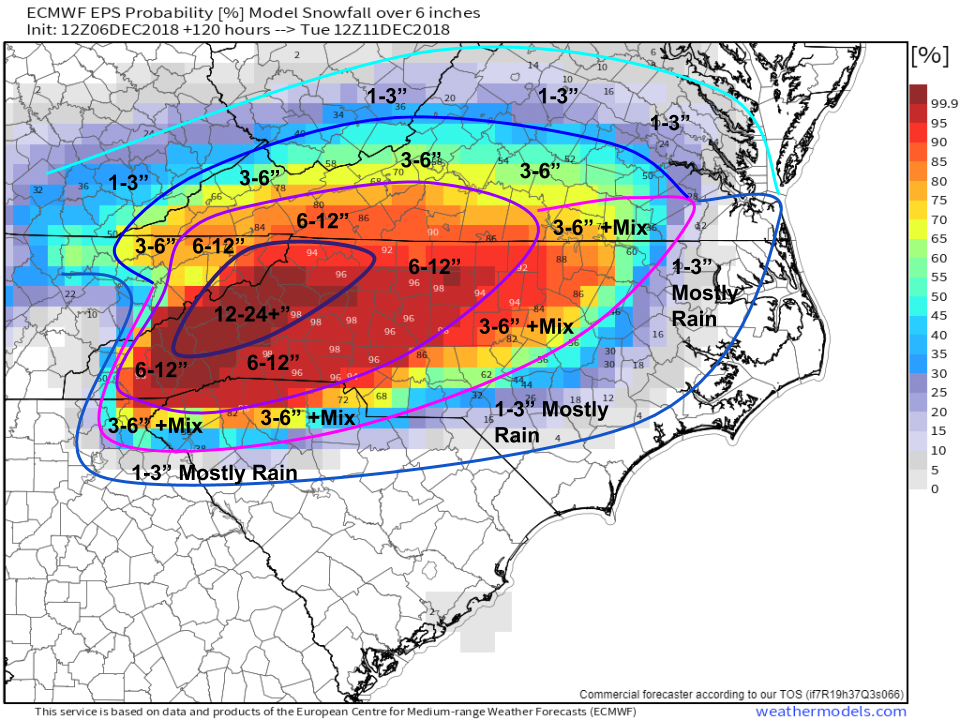
So how much snow is expected? Here’s my rough guess, using the ECMWF’s probabilistic guidance as a template. The mountains of western NC that keep that cooler air aloft and see a boost from orographic lifting will see well over a foot of snow. Over two feet is possible if temps aloft tick a bit cooler and ratios improve. Most of Central/Western NC will see 6-12″ at least from this system. I’m hesitant to commit to 12″+ outside of far western areas due to the potential for mixing, as well as the warm temps aloft that will cut down on ratios. However, over a foot of snow is possible all the way into the Charlotte-Greensboro area, especially if the Monday part of the storm ends up being a bit more energetic. Farther southeast, we’ll see an initial “front-end thump” of snow due to evaporational cooling before a change to rain on Sunday. More snow is possible on Monday as that secondary part of the system swings through, but the details of that evolution are still TBD. Snow totals in Virginia will be limited by the availability of moisture, though they’ll be deep enough in the cold air to avoid any mixing issues.