
09/12/2018/
Hello everyone!
Major Hurricane Florence is churning towards the coastline this morning as a category 4 storm with 130 mph winds. A better understanding of the upper level pattern has opened up a new idea forecast-wise for Florence, which is what this post will primarily be discussing. Note that these changes to the forecast exist only after Florence arrives either in or within a few miles of Wilmington NC. Coastal NC will see major impacts from Florence, regardless of what happens this weekend.
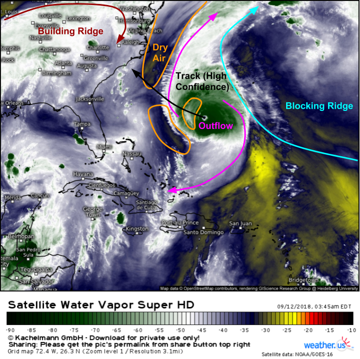
GOES-East Water Vapor satellite imagery (click here for satellite tutorial video) provides a great overview of Florence and the surrounding pattern this morning. The storm is clearly visible near the center of the frame, with upper-level outflow extending both north and south of the storm. While the system overall remains quite healthy, there are some pockets of dry air on the storm’s western side, and these will continue to limit the potential for further intensification. That being said, Florence could remain at the same intensity, or even weaken substantially, and remain an extremely dangerous storm! Also visible, especially in looped imagery, are the two ridges of high pressure that will be steering the storm over the next few days. Currently, the block to Florence’s NE is the stronger of the ridges and thus exerting the stronger NW steering influence. Once the ridge to Florence’s NW takes over, steering currents will shift.
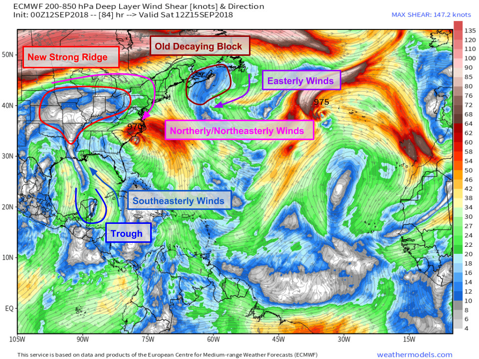
What do those shifts look like? The ECMWF’s shear forecast, which can act as a rough proxy for steering currents, explains. The large blocking ridge of high pressure we’ve been discussing for the past several days, which is currently steering Florence to the northwest, is set to collapse on Friday and will be all but gone by Saturday morning (which is the valid time for the shear map above). This means that the force pushing the storm northwest will disappear. Perhaps unsurprisingly, the forecast implication is that the storm will stop moving northwest on Friday/Saturday. In fact, the storm is unlikely to move much if any on Friday and Saturday as there will be a period of near-zero steering currents before a new player arrives on the field.
That player is the ridge developing over the Great Lakes on the map above. That ridge will strengthen to become nearly as strong as the block that is in place now. Once it does so, northerly/northeasterly steering currents will develop, which will likely result in a westerly or even southwesterly motion.
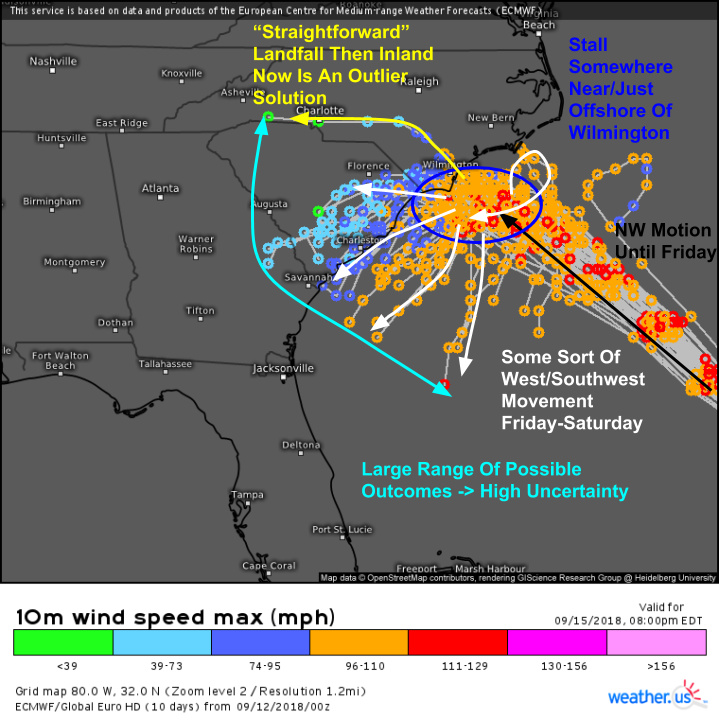
So what does all that upper-level stuff mean for Florence’s actual track? Our ECMWF ensemble storm tracks map above (click here for ensemble storm track tutorial video) shows three basic parts to Florence’s track over the next few days, each with a varying amount of forecast confidence. The northwesterly motion that brings Florence to a point somewhere near or over Wilmington is high confidence. The idea that Florence will dramatically slow down to a crawl, or even stall out entirely, either over or just SE of Wilmington is high confidence. The exact point that the storm is located at when this happens will be crucial to determining impacts. That exact point has yet to be determined and is something that very likely we won’t know for sure until it actually happens. Then comes that west/southwest motion late Friday into Saturday. There’s medium/high confidence that this will happen in some form or another. There’s very low confidence in what it will actually look like in terms of how far SW/how far W/how strong the storm will be etc. This is something we’ll continue to refine in the coming days, so stay tuned for further forecast updates!
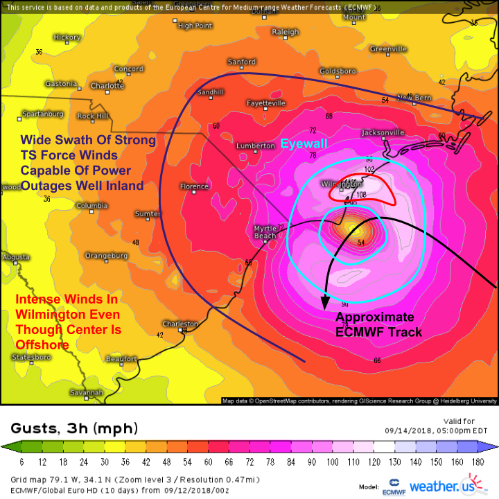
So what does this all have to do with impacts? Less than you might think. Due to that ridge building in overhead, there’s a very real chance that Florence doesn’t technically “make landfall” where the exact point of very lowest pressure moves over land. Does that mean that Wilmington/coastal NC is off the hook? Absolutely not. To illustrate that, check out this ECMWF map of forecast wind gusts for Friday evening. The center of the storm is offshore. However, Wilmington remains in the post powerful part of the eyewall, the NE quadrant, with winds over 100 mph. If the storm stalls out in this position, which current forecasts indicate it may, then the Wilmington area would be exposed to these extreme winds for a prolonged period of time. That’s not a done deal, as a stall 30 miles farther east would spare these areas from the worst of the inner core, but it highlights that this has the potential to be an extremely destructive storm regardless of if it makes an official landfall.
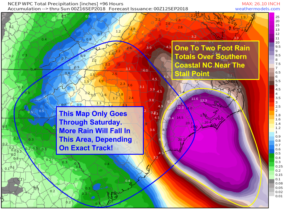
Here’s a look at rainfall totals, and how they may be impacted by the change in track idea. The bullseye for one to two-foot rain totals appears to be Eastern NC at this point, near the location where Florence stalls out (either right on the coast or just offshore). Keep in mind, extremely high rainfall totals in the outer bands where “training” of thunderstorms occurs will happen, they’re just not going to show up on a regional rainfall map like this one. For this reason, and due to continued forecast uncertainty, residents of Southern VA and NC should finish preparing, and remain prepared for significant flooding from Florence’s heavy rain. Note that this map only goes out through Saturday evening, when the storm will be moving west or southwest. Areas in the blue circle (roughly) may pick up the bulk of their rain after this time, so just because the numbers aren’t very big now doesn’t mean that you’re off the hook. This is especially true for South Carolina! We’ll have more detailed info on the flood threat to SC as we hone in on the track forecast in the coming days.
I’ll have another update here either late tonight or, perhaps more likely, early tomorrow morning.
Stay safe everyone!
-Jack