
Hello everyone!
Florence has rapidly intensified over the past couple days, just as forecast. The storm remains on track to slam into the Carolina coast as a powerful Category 3 or 4 hurricane on Thursday night or Friday morning. Because of increased confidence in track, this post will discuss impacts more than large scale steering/intensity dynamics. If you’re interested in that, very little has changed from my last post along those lines. The bottom line if you’re looking for it is that Florence will move onshore in North Carolina as a large and extremely dangerous major hurricane, with impacts including wind damage, storm surge inundation, and inland flooding from heavy rains.
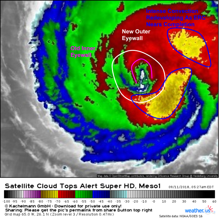
A look at GOES-East satellite imagery this morning shows some disorganization in Florence’s inner core. This is due to a process known as an eyewall replacement cycle (ERC). What’s an ERC? Basically, when a hurricane intensifies, it winds up, with the most intense energy concentrated in an increasingly small area near the center of the storm (the eyewall). Eventually, this area gets too concentrated, and the thunderstorms in the eyewall collapse. Simultaneously, a new outer eyewall is forming, with a larger and more stable configuration. Once the inner eyewall collapses, the outer eyewall takes over, and the storm continues strengthening. This is the process that Florence is going through this morning, and you can see the inner eyewall collapsing on satellite imagery, while the outer eyewall is intensifying.
So that’s cool, but what does it mean for the impact forecast?
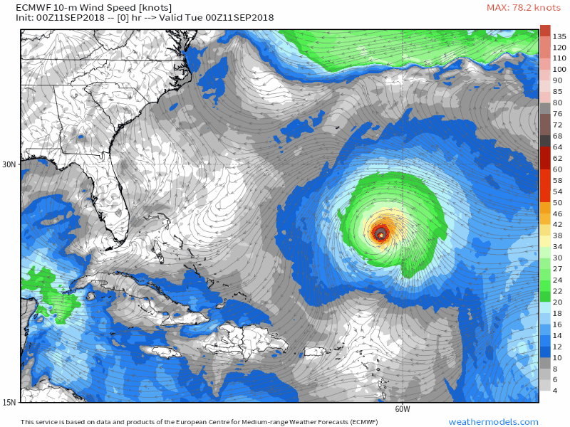
Because ERC’s redistribute the storm’s energy across a wider area, the storm grows in size. This ECMWF animation highlights that well. Note at the beginning of the loop how small Florence’s radius of hurricane force winds (>64kts/brown color) is compared to the end of the loop. As the storm redistributes its energy, its wind field expands, even if the maximum winds at the center aren’t quite as strong. A storm that brings 120 mph winds to a 50 mile stretch of coastline will be much more impactful than a storm that brings 130 mph winds to a 10 mile stretch of coastline. Just because Florence’s rapid intensification has stopped, or that latest max wind forecasts may not be quite as strong doesn’t mean this is any less dangerous of a storm!
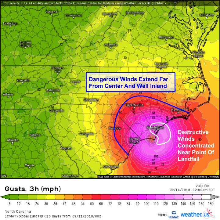
So what is the wind forecast for Florence as it moves ashore? This ECMWF map shows the same large wind field discussed above. While destructive winds over 100 mph will be concentrated near the center, slightly weaker but still extremely dangerous winds will extend much farther afield. The blue line on the map marks the model’s forecast for the 58 mph gust threshold (roughly). Why that number? Severe thunderstorm warnings are issued when thunderstorms produce wind gusts at or above 58 mph. Trees dangling over power lines/property don’t care if a 60 mph gust is produced by a hurricane or by a thunderstorm, the force is the same. So what’s the bottom line? Even winds below hurricane force can be extremely dangerous, and should be taken seriously even though the most intense winds will be confined to a small area.
What about the rain?
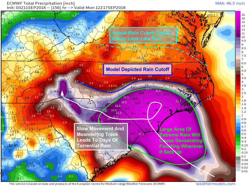
Rain is absolutely going to be Florence’s most devastating impact. Winds will cause damage, especially near the coast, but also inland. Surge will cause damage along the shorelines. But neither the extreme winds nor the extreme surge will have the geographical extent of the extreme rain. Totals over a foot are forecast for a wide swath of interior NC/SC, and could extend into VA too. The ECMWF model here is just one illustration of how this might look. Just because this particular model doesn’t forecast the extreme rains extending very far into N NC/VA doesn’t mean that it won’t happen! There will likely be a fairly sharp cutoff, we just don’t know exactly where it will set up.
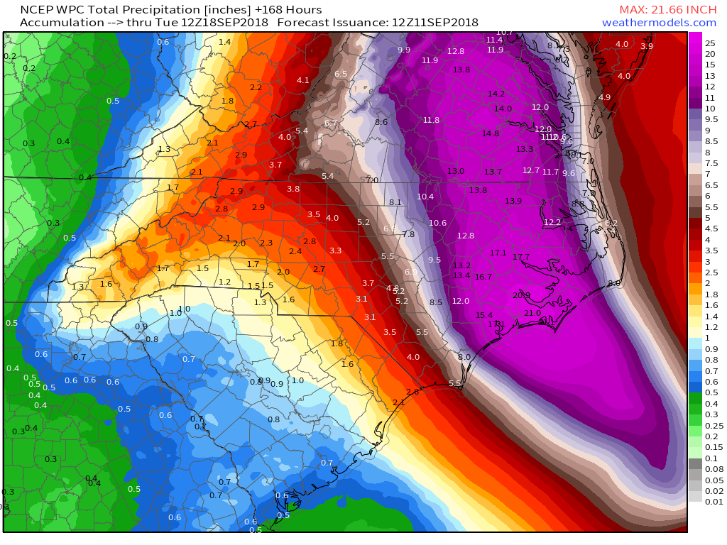
For the sake of comparison, here’s the official WPC rainfall forecast. Notice how it’s quite different, with the axis of heaviest rain farther east, and extending farther north. The uncertainty in the rainfall forecast exists because of uncertainty regarding how Florence will move after it makes landfall. There are many variables that will go into that, and they will all be discussed here in the coming days as we get closer to figuring it out. The takeaway for residents of interior NC, SC, and VA should be that a devastating inland flooding event is becoming increasingly likely, and now is the time to be preparing in case it does come to fruition.
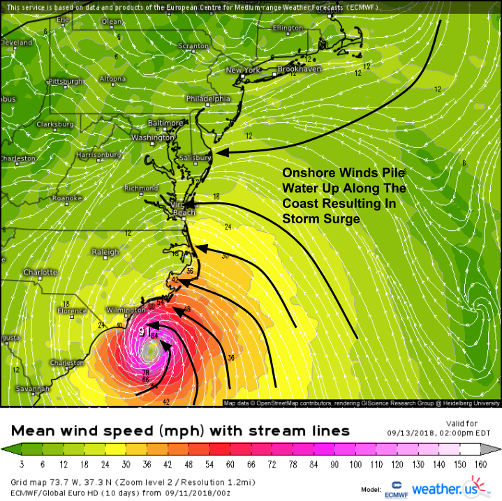
Storm surge will be a huge issue with Florence as onshore winds pile water up against the coast. Surge will be most impactful from Hampton Roads VA down through the Outer Banks towards Wilmington. Parts of the Outer Banks could see surge heights over 10 feet, with large battering waves on top of that only further enhancing its destructive power. Storm surge is one of the most dangerous impacts from landfalling tropical cyclones. Please take it seriously and evacuate if you’re told to by local officials!