
FIRST ALERT HURRICANE — SPECIAL WINTER WEATHER DISCUSSION
 EUROPEAN WEATHER MODEL RAISES EYEBROWS —
 COULD A MAJOR POLAR VORTEX DISRUPTION BE DEVELOPING FOR EARLY NOVEMBER?
 EL NIÑO MAY NOT HAVE THE FINAL WORD THIS WINTER! A POTENTIAL ARCTIC PATTERN CHANGE COULD THROW A MONKEY WRENCH INTO THE WINTER FORECASTS!
 Meteorological Analysis by Louis Smith

ACCURACY OVER FIRST — FACTS, NOT FEAR
━━━━━━━━━━━━━━━━━━
THE OLD-SCHOOL METEOROLOGIST’S DISCUSSION — SOMETHING INTERESTING IS BREWING OVER THE ARCTIC!
Folks, I’ve been studying weather maps for a long time, and every once in a while, a computer model produces something that makes you put down your coffee, lean forward in your chair, and take another look.
Well, the European weather model has produced one of those interesting projections for early November!
And before anybody st arts running to the grocery store buying bread, milk, and enough toilet paper to survive another ice age, let me explain what we’re actually looking at.
 arts running to the grocery store buying bread, milk, and enough toilet paper to survive another ice age, let me explain what we’re actually looking at.
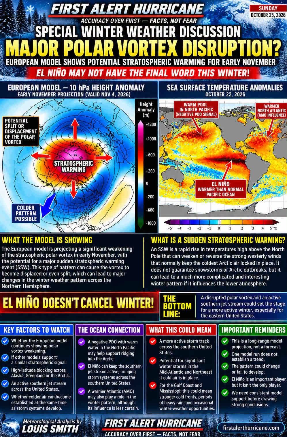
We’re talking about a possible major disruption of the polar vortex, potentially involving a sudden stratospheric warming event.
Now, that’s a mighty big deal in the world of winter meteorology, but it doesn’t automatically mean snowstorms, Arctic outbreaks, or a repeat of some historic winter.
What it does mean is that we need to start paying close attention to what is happening high above the North Pole.
━━━━━━━━━━━━━━━━━━
THE POLAR VORTEX — LET’S GET BACK TO THE BASICS!Back in the old days, before everybody started treating one computer model run like it was written on stone tablets, we studied the upper-air charts, pressure patterns, temperature fields, and atmospheric circulation.
And one of the most important players in winter weather is the stratospheric polar vortex.
During a typical winter, powerful westerly winds circulate around the Arctic high above the Earth’s surface, helping contain extremely cold air in the polar region.
But occasionally, large atmospheric waves traveling upward from the troposphere disturb that circulation.
Temperatures in the polar stratosphere can rise dramatically, and those strong westerly winds can weaken or even reverse.
That’s what meteorologists call a sudden stratospheric warming event, or SSW.
Sometimes the vortex becomes displaced away from the North Pole. Other times, it can split into separate circulation centers.
And when those disruptions eventually influence the lower atmosphere, the entire Northern Hemisphere weather pattern can become considerably more complicated.
But remember something important: A disrupted polar vortex does not guarantee that Arctic air will invade the United States.
The location of the blocking patterns, jet stream configuration, and timing determine where the cold air eventually travels.
━━━━━━━━━━━━━━━━━━
 THE EUROPEAN MODEL — IS IT SEEING SOMETHING THE OTHERS ARE MISSING?
The European model projection being discussed suggests the possibility of a significant weakening or even splitting of the stratospheric polar vortex during early November.
That’s an aggressive scenario, especially this early in the cold-weather season.
Some model guidance may support a degree of vortex disturbance, but there is a tremendous difference between a temporary weakening and a full-fledged major sudden stratospheric warming event.
And that’s where old-school meteorology comes into play.
One model run doesn’t establish a trend, and one dramatic chart certainly doesn’t make a winter forecast!
We need to watch whether the signal persists through successive model cycles, whether the ensemble members begin clustering around a similar solution, and whether the stratospheric wind and temperature forecasts support a genuine major warming.
If the European model continues showing a substantial disruption, and other guidance begins moving in that direction, then we’ll have something worth discussing in much greater detail.
━━━━━━━━━━━━━━━━━━
 THE PACIFIC OCEAN MAY HOLD ONE OF THE KEYS!
Now here’s where things get particularly interesting.
We have to look beyond El Niño and examine the broader Pacific Ocean temperature pattern.
The Pacific Decadal Oscillation, or PDO, can influence the distribution of warm and cold ocean temperatures across the North Pacific.
A negative PDO pattern, combined with favorable atmospheric circulation, could help support ridging over portions of the northern Pacific and toward Alaska.
And if that ridging extends far enough north, it can influence the movement of large atmospheric waves into the Arctic.
Those waves are among the mechanisms capable of disturbing the polar vortex.
But ocean temperatures alone don’t determine where high-pressure ridges develop. The atmosphere has to cooperate.
That’s why you cannot forecast an entire winter simply by looking at El Niño!
We also have to consider the Quasi-Biennial Oscillation, Arctic Oscillation, North Atlantic Oscillation, Pacific circulation, and the overall configuration of the jet stream.
Every one of these atmospheric players can influence the eventual outcome.
━━━━━━━━━━━━━━━━━━
COULD THE EASTERN UNITED STATES BE HEADING TOWARD A MORE ACTIVE WINTER?Here’s the question that really interests me.
What happens if we develop a strong southern branch of the jet stream associated with El Niño while Arctic blocking becomes established farther north?
Well, folks, that’s a combination worth watching!
A more active southern jet stream can transport Pacific moisture and support storm development across the southern United States.
Meanwhile, high-latitude blocking can sometimes allow colder air to move southward into the central and eastern United States.
When those two ingredients come together in the right location at the right time, the potential exists for significant winter storms.
That could become particularly important for the Mid-Atlantic and Northeast, where the interaction between cold air, coastal low-pressure development, and Atlantic moisture can produce major snowstorms.
But the ingredients must line up. An active storm track without sufficient cold air often means rain rather than snow.
And down here across Mississippi, Alabama, Louisiana, and the northern Gulf Coast, the same broad pattern could influence the frequency of strong cold fronts, heavy rainfall, and occasional winter-weather opportunities.
I’m not forecasting a major winter storm for the Gulf Coast or Northeast. I’m explaining the atmospheric setup that would deserve attention if it develops.
━━━━━━━━━━━━━━━━━━
EL NIÑO DOES NOT MEAN WINTER IS CANCELED!This is something I’ve said for years.
Mother Nature doesn’t read seasonal outlooks!
El Niño can strongly influence the winter circulation across North America, but it doesn’t control every atmospheric process.
Sudden stratospheric warming events can occur during El Niño winters, although their frequency, timing, and impacts vary with the background atmospheric conditions.
The PDO, QBO, Arctic circulation, and Atlantic sea-surface temperature patterns can all complicate the picture.
And the Atlantic Multidecadal Oscillation, or AMO, may provide additional background context, although its direct influence on an individual winter is considerably less certain.
So when somebody tells you that a strong El Niño automatically eliminates the possibility of a harsh eastern winter, I’d suggest pulling out the upper-air charts before accepting that conclusion.
Winter forecasting is about atmospheric relationships, not one climate index!
━━━━━━━━━━━━━━━━━━
 WHAT I’LL BE WATCHING OVER THE NEXT SEVERAL WEEKS
 Whether the European model continues forecasting significant polar vortex weakening. Whether other ensemble systems develop a similar stratospheric signal. Whether forecast temperatures and zonal winds near 10 millibars support a major warming event. Whether high-pressure blocking strengthens across Alaska, Greenland, or the Arctic. Whether the southern jet stream becomes increasingly active across the United States. Whether colder air can become established across eastern North America at the same time as storm systems develop.
━━━━━━━━━━━━━━━━━━
 MY OLD-SCHOOL METEOROLOGICAL TAKE — DON’T WRITE OFF WINTER JUST YET!
Folks, I’m going to play devil’s advocate here.
I know there are seasonal forecasts suggesting that the background El Niño pattern will dominate much of the winter.
And there are legitimate scientific reasons for those expectations.
But I’ve also learned something from decades of studying weather maps.
Sometimes the atmosphere has a few surprises waiting that the seasonal outlooks haven’t fully accounted for.
The European model’s aggressive polar vortex scenario may turn out to be overdone. The disturbance could weaken, fail to develop, or never produce a meaningful change in the weather across North America.
That’s entirely possible.
But if we begin seeing persistent evidence of high-latitude blocking, a weakening polar vortex, and an active southern jet stream, then the winter forecast could become much more interesting.
And if those ingredients eventually come together, parts of the eastern United States could experience a winter considerably different from what some early seasonal projections suggest.
We’re still dealing with possibilities, not certainties.
The next several weeks should help determine whether this is simply another dramatic long-range model projection or the early signal of a meaningful atmospheric pattern change.
And believe me, I’ll be watching those upper-air charts closely!
Because when it comes to winter weather, I still believe in the old-fashioned approach.
Follow the pressure patterns. Study the jet stream. Watch the Arctic. Compare the models. And never confuse a computer projection with an actual forecast.
BOTTOM LINE: EL NIÑO MAY BE AN IMPORTANT PLAYER THIS WINTER, BUT IT ISN’T THE ONLY PLAYER ON THE FIELD!And until we see how these atmospheric features evolve, I wouldn’t be ready to declare winter over before it even begins.
FIRST ALERT HURRICANEMeteorological Analysis by Louis Smith
ACCURACY OVER FIRST — FACTS, NOT FEAR
This discussion examines a potential long-range atmospheric scenario. A major sudden stratospheric warming event, polar vortex split, or significant winter storm pattern has not been established by the model information provided.
