
09/01/2018/
Hello everyone!
A few days ago, I discussed the state of the tropical Atlantic, and why it was likely to become more active in the days and weeks to come. Sure enough, that’s exactly what we’re seeing today, with two systems to watch in the Atlantic basin. The more organized of the two systems, Tropical Storm Florence, is located a couple hundred miles off the African coast. Any impacts it may bring to the US would be 10-15 days from now, so we have plenty of time to watch it. The other system, a tropical wave currently in the Bahamas, is much less organized, but is likely to bring impacts to the Gulf of Mexico this week, so it’s worth taking a closer look at. This post will quickly run through the forecast for this wave, including why it has the potential to spin up into a more impactful storm.
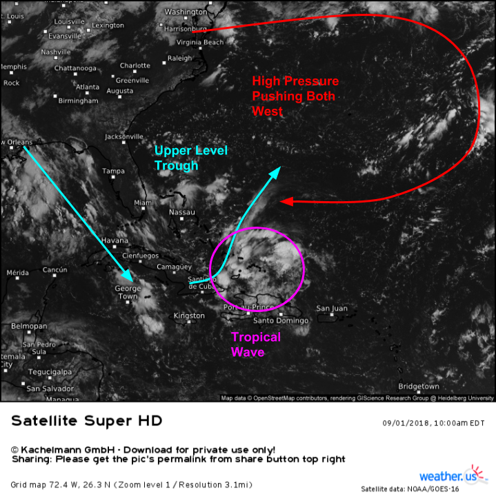
Here’s a look at the wave this morning, as well as its surrounding environment. Upper level winds can be inferred from the direction in which thunderstorm anvils are being blown. Notice the high (anvil) clouds being blown southeast from the storms in the Gulf of Mexico, while the anvil clouds associated with the tropical wave’s storms are being blown northeast. This highlights the presence of an upper level trough centered between Miami and Nassau. This trough is applying pressure to the tropical wave, keeping it from organizing much in the near term. To the north/northeast, a ridge of high pressure is pushing both the trough and the wave west-northwestward, towards the Gulf of Mexico.
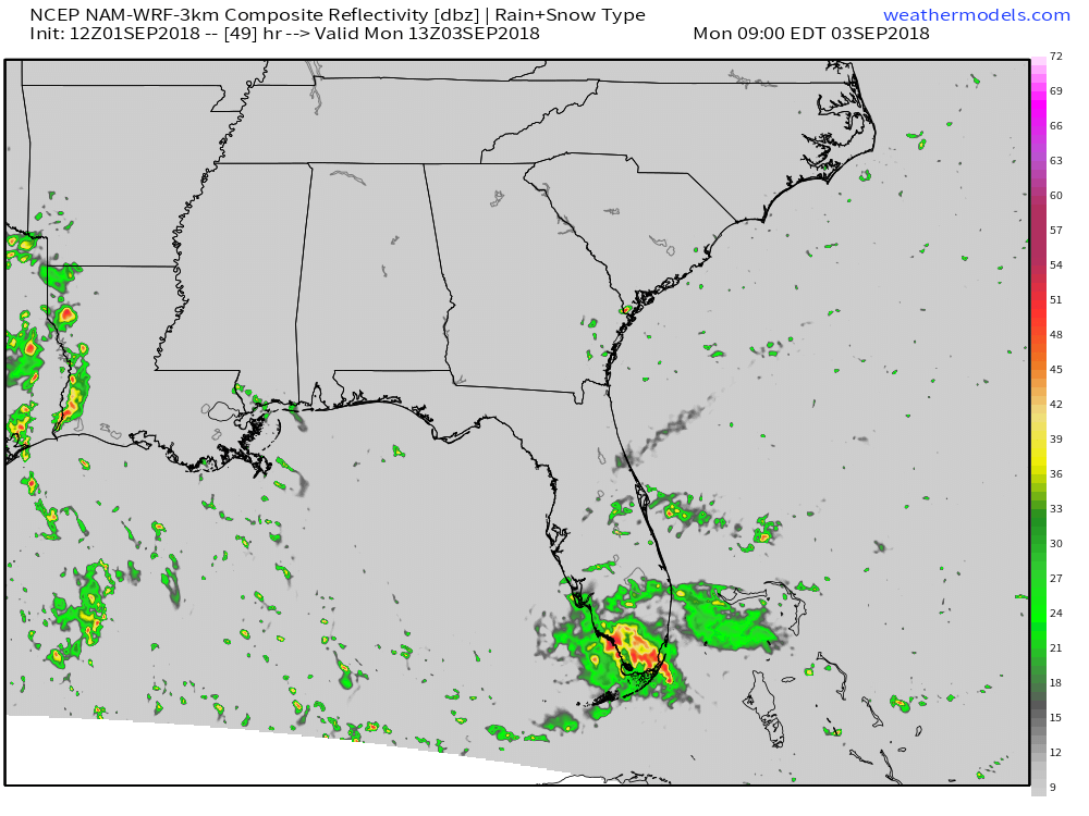
The system will arrive in Southern Florida on Monday morning, likely remaining in a disorganized state. The simulated radar map above shows an area of disorganized shower and thunderstorm activity associated with the system, but nothing more. Residents of Southern Florida should expect some heavy rain, and perhaps breezier than normal conditions, but nothing too serious. Low lying areas that typically fill up with water during thunderstorms will likely experience flooding, but otherwise impacts should remain low.
Map via weathermodels.com.
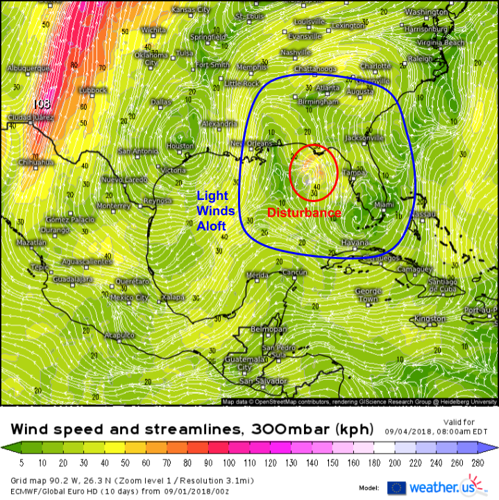
By the time the disturbance emerges into the Gulf of Mexico on Tuesday, the trough currently shearing it with strong upper level winds will weaken, and the disturbance will occupy an area of light winds aloft. This will let the system develop a bit as it moves over the very warm waters of the Gulf of Mexico. Just how much the system develops will depend on how much time it has over water. The farther south it tracks, the longer it will spend over water, and the stronger it will be. The opposite would be true for a system moving farther to the north where interference with land would lead to a weaker system.
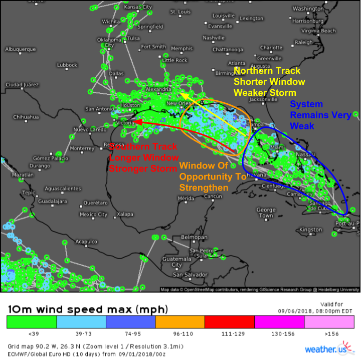
A look at ECMWF EPS storm track forecasts shows a pretty narrow range of possible outcomes for our disturbance. The storm will remain weak until it emerges into the Gulf of Mexico on Monday afternoon. At that point, the storm will have a window of opportunity to strengthen over the warm Gulf waters and under those light upper level winds. If the storm tracks farther north, that window will be shorter before the system moves onshore somewhere near New Orleans. If the storm tracks farther south, that window will be longer before the storm moves onshore somewhere in Texas. A longer window of opportunity would lead to a stronger storm, with the opposite also being true.
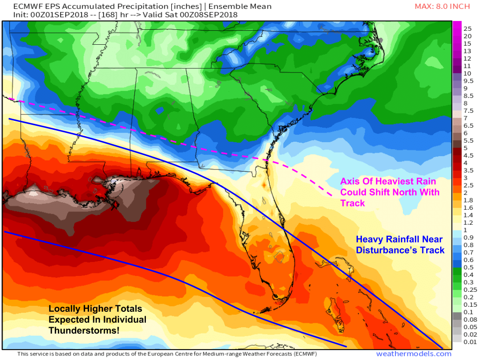
Regardless of the storm’s eventual track and strength, heavy rain will impact the entire Gulf Coast over the next week due to the system. Widespread amounts of 3-5″ are expected, with totals in any particular town dependent on the exact placement of individual thunderstorms. Where thunderstorms linger/train (and they will), amounts will locally far exceed what’s shown here. The highest totals will be near Louisiana where thunderstorm activity is ongoing as a result of a separate disturbance already. That disturbance will not develop into a tropical storm, but it will “prime the pump” so to speak for the incoming system by saturating the soil. Keep in mind that there’s still some uncertainty regarding the eventual storm’s exact track, so the axis of heavy rain could easily shift north (or south). Overall, impacts from rain shouldn’t be excessive, but if your area is prone to flooding, now is a good time to prepare for rising waters.
Map via weathermodels.com.
I’ll have more updates in the coming days as the forecast for this system becomes clearer. You can follow the system with GOES-East satellite imagery at weather.us, where you’ll also find computer model forecasts for the storm. Remember, each individual computer model forecast is only one idea of what might happen. It’s not a definite solution! If a model happens to spit out a menacing forecast, don’t panic, it’s probably unlikely. If this system does become a greater threat, you’ll hear a word from the National Hurricane Center, your local NWS office, local media, and me here on the blog.