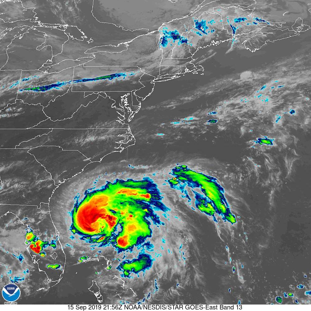
NOAA/NESDIS/STAR GOES ABI BAND 13 OR_ABI-L1b-RadC-M6C13_G16_s20192582156145_e20192582158529_c20192582159057.nc
BULLETIN
Tropical Storm Humberto Advisory Number  13
NWS National Hurricane Center Miami FL       AL092019
500 PM EDT Sun Sep 15 2019

...HUMBERTO CONTINUES TO STRENGTHEN...
...RIP CURRENT THREAT WILL INCREASE ALONG THE SOUTHEASTERN UNITED
STATES COAST THROUGH TUESDAY...


SUMMARY OF 500 PM EDT...2100 UTC...INFORMATION
----------------------------------------------
LOCATION...29.3N 78.0W
ABOUT 210 MI...335 KM NNW OF GREAT ABACO ISLAND
ABOUT 170 MI...270 KM ENE OF CAPE CANAVERAL FLORIDA
MAXIMUM SUSTAINED WINDS...70 MPH...110 KM/H
PRESENT MOVEMENT...N OR 360 DEGREES AT 6 MPH...9 KM/H
MINIMUM CENTRAL PRESSURE...989 MB...29.21 INCHES


WATCHES AND WARNINGS
--------------------
There are no coastal watches or warnings in effect.

Interests in and around Bermuda should monitor the progress of
Humberto.


DISCUSSION AND OUTLOOK
----------------------
At 500 PM EDT (2100 UTC), the center of Tropical Storm Humberto was
located by reconnaissance aircraft and NOAA Doppler radars near
latitude 29.3 North, longitude 78.0 West. Humberto is moving toward
the north near 6 mph (9 km/h),  and this motion is expected to
continue through tonight. A sharp turn to the northeast is forecast
to occur Monday morning or afternoon, followed by a motion toward
the northeast and east-northeast on Tuesday and Wednesday. On the
forecast track, the center of Humberto will continue to move away
from the Bahamas and remain well offshore of the southeastern coast
of the United States through Wednesday.

Data from an Air Force Reserve reconnaissance aircraft indicate that
maximum sustained winds have increased to near 70 mph (110 km/h)
with higher gusts. Further strengthening is expected during the next
few days, and Humberto is expected to become a hurricane later
tonight.

Tropical-storm-force winds extend outward up to 150 miles (240 km)
from the center.

The minimum central pressure based on aircraft data is estimated
to be 989 mb (29.21 inches).


HAZARDS AFFECTING LAND
----------------------
RAINFALL:  Outer rain bands associated with Humberto are expected
to produce additional rainfall of 1 to 2 inches in the central and
northern Bahamas, with isolated storm total amounts of 6 inches.
Humberto may bring periods of heavy rain to Bermuda beginning late
Wednesday.

SURF:  Swells generated by Humberto will affect the northwestern
Bahamas, and the southeastern coast of the United States from
east-central Florida to North Carolina during the next few days.
These swells could cause life-threatening surf and rip current
conditions.  Please consult products from your local weather
office.


NEXT ADVISORY
-------------
Next complete advisory at 1100 PM EDT.
TROPICAL STORM HUMBERTO WIND SPEED PROBABILITIES NUMBER  13
NWS NATIONAL HURRICANE CENTER MIAMI FL       AL092019
2100 UTC SUN SEP 15 2019

AT 2100Z THE CENTER OF TROPICAL STORM HUMBERTO WAS LOCATED NEAR
LATITUDE 29.3 NORTH...LONGITUDE 78.0 WEST WITH MAXIMUM SUSTAINED
WINDS NEAR 60 KTS...70 MPH...110 KM/H.

Z INDICATES COORDINATED UNIVERSAL TIME (GREENWICH)
   ATLANTIC STANDARD TIME (AST)...SUBTRACT 4 HOURS FROM Z TIME
   EASTERN  DAYLIGHT TIME (EDT)...SUBTRACT 4 HOURS FROM Z TIME
   CENTRAL  DAYLIGHT TIME (CDT)...SUBTRACT 5 HOURS FROM Z TIME

WIND SPEED PROBABILITY TABLE FOR SPECIFIC LOCATIONS

CHANCES OF SUSTAINED (1-MINUTE AVERAGE) WIND SPEEDS OF AT LEAST
   ...34 KT (39 MPH... 63 KM/H)...
   ...50 KT (58 MPH... 93 KM/H)...
   ...64 KT (74 MPH...119 KM/H)...
FOR LOCATIONS AND TIME PERIODS DURING THE NEXT 5 DAYS

PROBABILITIES FOR LOCATIONS ARE GIVEN AS OP(CP) WHERE
    OP  IS THE PROBABILITY OF THE EVENT BEGINNING DURING
        AN INDIVIDUAL TIME PERIOD (ONSET PROBABILITY)
   (CP) IS THE PROBABILITY OF THE EVENT OCCURRING BETWEEN
        18Z SUN AND THE FORECAST HOUR (CUMULATIVE PROBABILITY)

PROBABILITIES ARE GIVEN IN PERCENT
X INDICATES PROBABILITIES LESS THAN 1 PERCENT
PROBABILITIES FOR 34 KT AND 50 KT ARE SHOWN AT A GIVEN LOCATION WHEN
THE 5-DAY CUMULATIVE PROBABILITY IS AT LEAST 3 PERCENT.
PROBABILITIES FOR 34...50...64 KT SHOWN WHEN THE 5-DAY
64-KT CUMULATIVE PROBABILITY IS AT LEAST 1 PERCENT.


  - - - - WIND SPEED PROBABILITIES FOR SELECTED LOCATIONS - - - -

               FROM    FROM    FROM    FROM    FROM    FROM    FROM
  TIME       18Z SUN 06Z MON 18Z MON 06Z TUE 18Z TUE 18Z WED 18Z THU
PERIODS         TO      TO      TO      TO      TO      TO      TO
             06Z MON 18Z MON 06Z TUE 18Z TUE 18Z WED 18Z THU 18Z FRI

FORECAST HOUR    (12)   (24)    (36)    (48)    (72)    (96)   (120)
- - - - - - - - - - - - - - - - - - - - - - - - - - - - - - - - - -
LOCATION       KT

HIBERNIA OILFD 34  X   X( X)   X( X)   X( X)   X( X)   X( X)   3( 3)

CAPE RACE NFLD 34  X   X( X)   X( X)   X( X)   X( X)   X( X)   5( 5)

ILE ST PIERRE  34  X   X( X)   X( X)   X( X)   X( X)   X( X)   4( 4)

BURGEO NFLD    34  X   X( X)   X( X)   X( X)   X( X)   X( X)   3( 3)

SYDNEY NS      34  X   X( X)   X( X)   X( X)   X( X)   X( X)   3( 3)

SABLE ISLAND   34  X   X( X)   X( X)   X( X)   X( X)   X( X)   8( 8)
SABLE ISLAND   50  X   X( X)   X( X)   X( X)   X( X)   X( X)   3( 3)
SABLE ISLAND   64  X   X( X)   X( X)   X( X)   X( X)   X( X)   1( 1)

CAPE HATTERAS  34  X   1( 1)   3( 4)   2( 6)   2( 8)   X( 8)   X( 8)

CHERRY PT NC   34  X   1( 1)   2( 3)   1( 4)   1( 5)   X( 5)   X( 5)

NEW RIVER NC   34  1   3( 4)   4( 8)   2(10)   2(12)   X(12)   X(12)

MOREHEAD CITY  34  1   4( 5)   3( 8)   2(10)   2(12)   X(12)   X(12)

SURF CITY NC   34  1   1( 2)   2( 4)   1( 5)   1( 6)   X( 6)   X( 6)

WILMINGTON NC  34  1   1( 2)   2( 4)   1( 5)   1( 6)   X( 6)   X( 6)

BALD HEAD ISL  34  3   3( 6)   3( 9)   3(12)   1(13)   X(13)   X(13)

LITTLE RIVER   34  1   1( 2)   2( 4)   1( 5)   X( 5)   X( 5)   X( 5)

MYRTLE BEACH   34  3   3( 6)   3( 9)   1(10)   1(11)   X(11)   X(11)

GEORGETOWN SC  34  1   1( 2)   2( 4)   1( 5)   X( 5)   X( 5)   X( 5)

CHARLESTON SC  34  1   1( 2)   2( 4)   X( 4)   X( 4)   X( 4)   X( 4)

BEAUFORT MCAS  34  1   1( 2)   1( 3)   X( 3)   X( 3)   X( 3)   X( 3)

SAVANNAH GA    34  1   1( 2)   1( 3)   X( 3)   X( 3)   X( 3)   X( 3)

KINGS BAY GA   34  1   1( 2)   1( 3)   X( 3)   X( 3)   X( 3)   X( 3)

MAYPORT NS FL  34  3   3( 6)   1( 7)   1( 8)   X( 8)   X( 8)   X( 8)

JACKSONVILLE   34  1   1( 2)   1( 3)   X( 3)   X( 3)   X( 3)   X( 3)

DAYTONA BEACH  34  1   2( 3)   1( 4)   X( 4)   X( 4)   X( 4)   X( 4)

ORLANDO FL     34  1   2( 3)   X( 3)   X( 3)   X( 3)   X( 3)   X( 3)

COCOA BEACH FL 34  3   3( 6)   2( 8)   X( 8)   X( 8)   X( 8)   X( 8)

PATRICK AFB    34  1   2( 3)   1( 4)   X( 4)   X( 4)   X( 4)   X( 4)

FT PIERCE FL   34  3   3( 6)   2( 8)   X( 8)   X( 8)   X( 8)   X( 8)

W PALM BEACH   34  3   3( 6)   1( 7)   X( 7)   X( 7)   X( 7)   X( 7)

FT LAUDERDALE  34  2   3( 5)   X( 5)   X( 5)   X( 5)   X( 5)   X( 5)

BERMUDA        34  X   X( X)   X( X)   X( X)  22(22)  57(79)   1(80)
BERMUDA        50  X   X( X)   X( X)   X( X)   3( 3)  44(47)   1(48)
BERMUDA        64  X   X( X)   X( X)   X( X)   1( 1)  24(25)   X(25)

GRAND BAHAMA   34  3   3( 6)   3( 9)   1(10)   X(10)   X(10)   X(10)

NEW PROVIDENCE 34  2   2( 4)   X( 4)   X( 4)   X( 4)   X( 4)   X( 4)
Tropical Storm Humberto Discussion Number  13
NWS National Hurricane Center Miami FL       AL092019
500 PM EDT Sun Sep 15 2019

Humberto's convective structure continues to improve in satellite
imagery and reflectivity data from the Melbourne NOAA Doppler
weather radar, including intermittent appearances of a closed eye.
An Air Force Reserve reconnaissance aircraft investigating Humberto
this afternoon found SFMR winds of 58-59 kt in the northeastern
quadrant outside of the heaviest rain areas, and that the pressure
had fallen 4 mb during the past 2 hours, now down to 989 mb.  Based
on these data, the intensity has been increased to 60 kt.

The initial motion estimate is now 360/05 kt. There are no
significant changes to the previous forecast track or reasoning.
Humberto is likely located on or near an east-west oriented ridge
axis, and a sharp turn toward the northeast is likely during the
next 6-12 hours. The latest NHC model guidance remains highly
convergent on the previous forecast track and continues to show the
cyclone gradually being accelerated toward the northeast and
east-northeast during the 24-120 hour period. The large deep-layer
trough and associated cold front that will be digging southward out
of eastern Canada and the northeastern United States is forecast by
the ECMWF model to develop a cutoff low over the northwestern
Atlantic that results in some binary interaction with Humberto on
day 5. However, this is a new development and is considered to be an
outlier scenario at this time. The new forecast track is similar to
the previous advisory and lies close to the TVCN and HCCA consensus
track models.

Likewise, there is no significant change to previous intensity
forecast. All of the available model guidance continues to support
steady strengthening for the 3 days. In 48-72 hours, Humberto is
forecast to be moving into the right-rear quadrant of a strong,
anticyclonically curved 300-200 mb jet maximum. The associated
strong baroclinic/dynamical forcing is expected to produce strong
pressure falls and strengthening despite the hostile vertical wind
shear conditions of at least 30 kt. On days 4 and 5, the combination
of slightly cooler waters, drier and more stable air, and much
stronger vertical shear of 40-50 kt should cause steady weakening
despite the favorable jetstream dynamics. The previous NHC intensity
forecast remains unchanged, and continues to show Humberto reaching
its peak intensity in 72 hours, coincident with the warmest
sea-surface temperatures and strongest jetstream dynamical forcing.

Large swells from Humberto will affect portions of the northwestern
Bahamas and southeastern United States coast during the next few
days.  These swells are expected to produce dangerous surf
conditions and life-threatening rip currents.  See products issued
by your local weather office for additional information.

FORECAST POSITIONS AND MAX WINDS

INIT  15/2100Z 29.3N  78.0W   60 KT  70 MPH
 12H  16/0600Z 29.8N  77.6W   65 KT  75 MPH
 24H  16/1800Z 30.1N  76.7W   70 KT  80 MPH
 36H  17/0600Z 30.4N  75.4W   80 KT  90 MPH
 48H  17/1800Z 30.7N  73.6W   85 KT 100 MPH
 72H  18/1800Z 31.7N  68.9W   95 KT 110 MPH
 96H  19/1800Z 35.0N  62.0W   85 KT 100 MPH
120H  20/1800Z 39.6N  56.1W   60 KT  70 MPH


![[Image of probabilities of 34-kt winds]](https://www.nhc.noaa.gov/storm_graphics/AT09/refresh/AL092019_wind_probs_34_F120+png/205241.png)

![[Image of initial wind radii]](https://www.nhc.noaa.gov/storm_graphics/AT09/refresh/AL092019_current_wind+png/205241_current_wind_sm.png)