
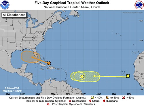
The National Hurricane Center is tracking three different areas for potential tropical development. The closest to the United States is Invest 95L
The model data
Now that the NHC has classified Invest 95L, the model data can run on it. Keep in mind that because there is no closed low and organized area o flow pressure for the models to ‘pick up on’ that the models will have a difficult time projecting the eventual specific path and eventual intensity of the system.
But, as of now, the model data isn’t terribly alarming at this point.
From the NHC
Tropical Weather Outlook…Corrected
NWS National Hurricane Center Miami FL
800 AM EDT Wed Sep 11 2019
For the North Atlantic…Caribbean Sea and the Gulf of Mexico:
1. Widespread cloudiness and showers extending from the southeastern Bahamas northward over the southwestern Atlantic for a few hundred miles are associated with a surface trough of low pressure. Limited development of this system is anticipated today or tomorrow, however conditions are forecast to become a little more favorable for development over the weekend, and a tropical depression could form as the disturbance moves slowly toward the west-northwest across the Florida Straits or South Florida and over the eastern Gulf of Mexico. Regardless of development, this disturbance could produce periods of locally heavy rainfall and
gusty winds across the Bahamas through Thursday, and across Florida during the weekend.
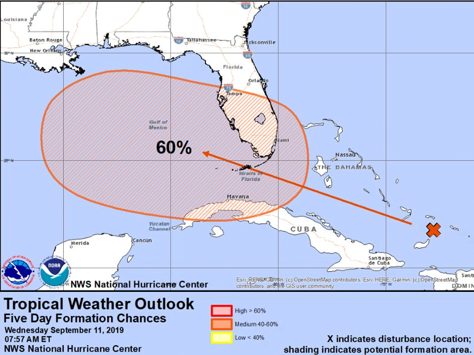
* Formation chance through 48 hours…low…20 percent.
* Formation chance through 5 days…medium…60 percent.
2. A broad low pressure system, associated with a tropical wave, is located about 650 miles east of the Lesser Antilles. This disturbance is accompanied by a large but disorganized area of cloudiness and thunderstorms. This system is forecast to move westward toward unfavorable upper-level winds for tropical cyclone formation.
* Formation chance through 48 hours…low…10 percent.
* Formation chance through 5 days…low…10 percent.
3. A tropical wave located between the west coast of Africa and the Cabo Verde Islands is forecast to move quickly westward during the next several days. Some slow development is possible over the weekend or early next week when the system is moving over the tropical Atlantic.
* Formation chance through 48 hours…low…near 0 percent.
* Formation chance through 5 days…low…20 percent.
At a Glance
- A tropical disturbance, Invest 95L, is near the Bahamas.
- It could develop into a tropical depression or storm by this weekend over the Gulf of Mexico.
- It should then move quickly inland along the northern Gulf Coast.
- Regardless of development, locally heavy rain is possible in parts of Florida and the Deep South.
- If it becomes a tropical storm, it would become Humberto.
A tropical disturbance near the Bahamas could become a tropical storm this weekend in the Gulf of Mexico, bringing locally heavy rain to parts of Florida and the Deep South.
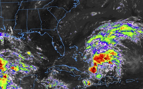
The disturbance is currently located over the Turks and Caicos, with clusters of showers and thunderstorms extending from eastern Cuba and just off the coast of Hispaniola north a few hundred miles.
The National Hurricane Center has tagged this system Invest 95L, a naming convention used by meteorologists to identify areas that are being monitored for possible tropical development.
For now, shearing winds are keeping the system from becoming better organized.

Current Satellite Image, Wind Shear Analysis
(Areas of clouds are shown in white. Areas of strong wind shear, the difference in wind speed and direction with height, are shown in purple. High wind shear is hostile to mature tropical cyclones and those trying to develop. The location of the disturbance is plotted by an “L”. )
Once the system moves into the Florida Straits and Gulf of Mexico Friday and this weekend, it may be in a more favorable environment for development.
Its environment may already be improving despite wind shear, with winds aloft spreading apart over the disturbance, supporting the growth and persistence of thunderstorms, as UNC-Charlotte graduate student Eric Webb noted.
The NHC has given it a medium chance of development into at least a tropical depression over the next five days.

Potential NHC Development
(The potential area(s) of tropical development according to the latest National Hurricane Center outlook are shown by polygons, color-coded by the chance of development over the next five days. An “X” indicates the location of a current disturbance.)
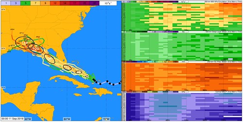
The system is expected to be drawn toward the northwest between a high-pressure system near Bermuda and an upper-level low-pressure system that will be to its west.

The features expected to steer the Gulf system this weekend.
The exact track of this system remains uncertain since there is not yet a low-pressure center.
However, it appears the system will come ashore somewhere along the northern Gulf Coast from Louisiana to Florida, as either a tropical depression or tropical storm around Sunday, according to the latest computer model forecast guidance. If it becomes a tropical storm, it would become Humberto.
Heavy Rain Threat
Regardless of what this system is called, periods of gusty winds and locally heavy rain can be expected the next few days from the Bahamas across Florida, then into parts of the South this weekend into at least early next week. This includes areas affected by Dorian in the northwestern Bahamas.
In general, the heaviest rain should fall along and to the east of the center of this system. Thus, the eastern half of the Gulf Coast has the best chance of soaking rain, while the western half may see little rain at all.
Local flash flooding is possible in areas where bands of rain stall or persist over an area.
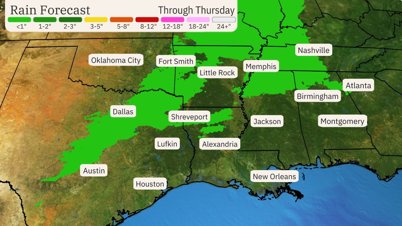
Rainfall Outlook
(Forecast rainfall through Monday night from the Gulf system. This is subject to change based on the path of the system. )
Some higher surf and rip currents may build along the northern and eastern Gulf Coast, as well as the Atlantic beaches of Florida, Georgia and the Carolinas into this weekend.
Check back with us at weather.com for the latest on this potential weekend system.