
The period Dec 21-Jan 10 will be the coldest 20 day period centered on the New Years since 2000-2001 for the nation as a whole. This has been my missive and still is. Chicago today only hit 5 for a high, well under what numbers a week ago had. Chicago is one of my benchmarks for an extreme outbreak. A 0 day. Others are a low o 10 at Dallas, or Atlanta, 0 in NYC, 26 in Orlando and Brownsville. All of these are on the table, Of course, whether they get served up or not is another story
As for the issue of snow. There is a big fight here going on with the modeling, The Euro is jumping all over a front-running feature that is a clipper that bombs out. A very cold storm with a direct discharge of arctic air behind it. But the GFS is flatter with that and jumps all over a second feature. You can see the major difference by 12z Saturday at 500
Euro
.png)
.png)
There are problems all over the place, not only over NAMER with these 2, but look at the difference in the Pacific as the Euro is kicking a feature along very quickly that eventually is a threat in the 8-10 I believe the Euro over the GFS as I think the changes in the Pacific are such that its tough to believe the US models, notorious for their lack of handling of the input from the tropics, would win this, However what is strange is its usually the euro that is slower ( I am talkng the feature on the map northeast of Hawaii. Bottom line the Euro wants to make the feature the GFS tries to make a storm just an appendage, the GFS wants to slow the pattern and amplify it. Its surface map is likely wrong ( may be a moot point since its likely wrong on the 500 MB) as it would likely be a wave on the arctic push, not the portrayed polar boundary feature out of the gulf
But in the 6-`0, there are amazing differences in the portrayal of the cold. The Euro models aim the severe period into the northeast
Operational
.png)
Control
.png)
Ensemble
.png)
The Canadian and US ensembles are back further west
.png)
.png)
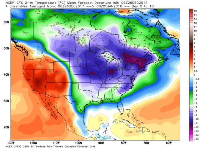
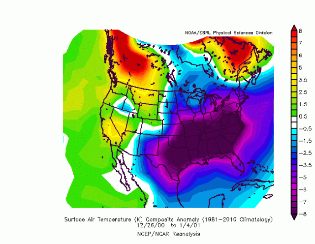
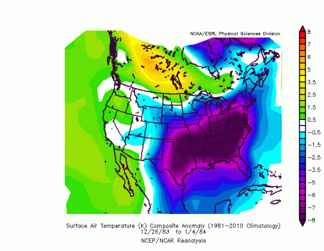
The 10 day-core of the cold started yesterday. The 7 day starts tomorrow, when the 20 days are done, we can go back and look at all the 20 day periods since 2000 and see how this stacks up. BTW if it winds up colder than 00-01, then we go back to the 80s
the -8C starts at the blue shade
Here is 00-01, deepest purple is -8c
But then to get as much coverage, we have to go to 83-84
We have to keep things in perspective. Snow, no snow, just the fact we got to a pattern this extreme to put some of these things on the table is something that is impressive. Models come and go and there is a lot going on. Tomorrows run may show something different but at the least, we have come a long way
Churchill is showing in theatres Never Surrender