
Hello everyone!
Florence remains a tropical storm this afternoon as it moves west though the Central Atlantic. The system has been struggling with dry air and wind shear over the past couple days, but is showing signs of improvement on satellite imagery today. The forecast for Florence remains similar to the thoughts presented in yesterday’s update. The system is likely to begin a period of steady, and potentially rapid, intensification in the next 24 hours, with major hurricane status expected by Monday. This update will provide a brief update on the track forecast, will dig into the intensity forecast a little bit, and take a peek at what could happen after Florence arrives on or very near the shores of the Southeastern US.
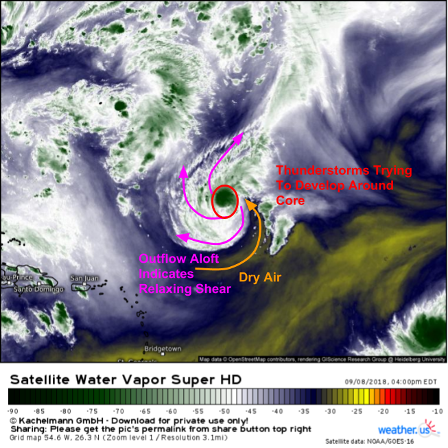
Here’s a look at GOES-East WV satellite imagery of Florence and its surroundings this afternoon (click here for a tutorial on satellite imagery at weather.us). The storm continues to struggle a little bit with dry air, but overall it’s looking much healthier than this time yesterday. Outflow expanding to the southwest is a good sign that outflow/ventilation is improving in the upper levels, and thunderstorms are popping up around the storm’s core. Once Florence can mix out that dry air, the stage is set for what is likely to be some pretty impressive intensification.

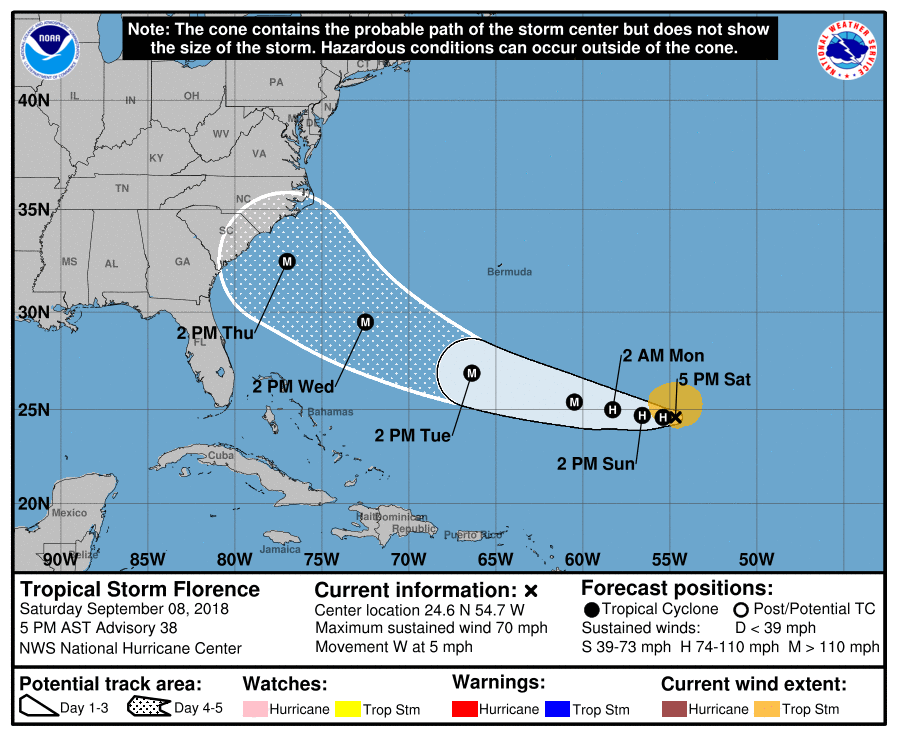
The steering setup remains similar to what was outlined yesterday. A very large ridge will build north of Florence, steering the system west then northwest towards the coast. This ridge will prevent an early escape out to sea, though one possible scenario involves Florence making a very close pass to the Outer Banks, but while the actual center stays out over water. While not currently expected, that is one reasonably plausible outcome to be aware of. The most likely track right now, according to the EPS data above (click here for a tutorial on ensemble cyclone tracks at weather.us), is towards a landfall somewhere either on the northern South Carolina coast, or along the coast of North Carolina. While that could still shift around a little bit, it’s definitely time for folks in those areas to prepare for impacts from what will by then be major hurricane Florence.
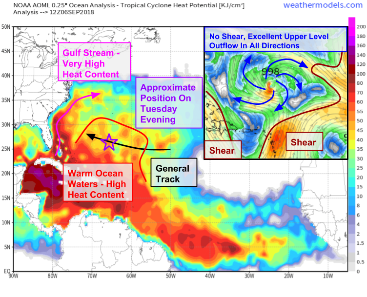
The intensity forecast for Florence remains similar to yesterday. The graphic above is what I included in yesterday evening’s update, and all the thinking remains the same so I see no need to redo it. We’ve already seen evidence on satellite imagery that shear over the system is relaxing, and we know that warm waters lie ahead. The storm’s inner core structure remains mostly intact after strong shear tried to disrupt it yesterday. All the ingredients are in place for rapid strengthening, and that’s exactly what’s forecast.

The ECMWF’s simulated IR imagery illustrates how this strengthening might look. Watch Florence begin as a disorganized blob, before transforming into a strong hurricane with a clearly visible eye. The ECMWF also highlights a reasonably middle of the road forecast landfall point, somewhere on the NC coast near Wilmington. There are some models you might see, including several run by the US modelling centers, that bring Florence up to an intense Category 4 or potentially even Category 5 hurricane.
Beware of these models, the environment isn’t quite perfect, as some dry air may linger near the storm in the next couple days. Especially beware the GFS model which keeps Florence unreasonably strong as it meanders near the Outer Banks. As powerful hurricanes churn up the ocean beneath themselves, cold water from under the surface gets mixed up. This cooling will take the hurricane’s fuel source out from under it (literally!), resulting in weakening. The ECMWF has the code to take this phenomenon into account, while the GFS doesn’t, which is one of the many reasons forecasters including myself generally give more weight to the ECMWF’s forecast.

So what will happen after Florence makes landfall? This loop of forecast upper level patterns from the ECMWF highlights one possible outcome that could be very problematic. You can easily track Florence as it moves onshore, then gets denied any northward motion past the VA/NC border due to another ridge of high pressure building from the Midwest into New England. The model then shoves the storm back to where it came from, over the course of nearly a week. Why would this be so problematic? A tropical cyclone moving slowly over the same area for days is a recipe for devastating inland flooding.
The last time we saw this phenomenon occur was last year in Texas, when dual ridges of high pressure teamed up to trap Harvey. Will Florence’s rain be as extreme as Harvey’s? Absolutely not. We’re not dealing with Gulf of Mexico moisture here. There will be no widespread 50″ rain totals. That being said, you don’t need Harvey-esque rainfall totals to produce major flooding issues.
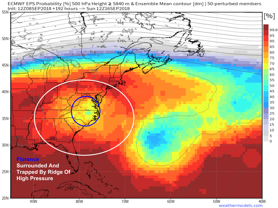
Additionally, the map above offers ensemble support for the scenario the operational model presented. That means that the idea of Florence stalling out for days after landfall isn’t just some one-off operational solution, it actually has merit. There’s still time for forecasts to adjust, and the axis of heaviest rainfall has yet to be pinned down, as do forecast rainfall amounts. However, residents of interior North Carolina, South Carolina, and Virginia need to be aware that even though Florence’s winds will have weakened by the time the storm moves inland, significant impacts are looking more and more likely from inland flooding.
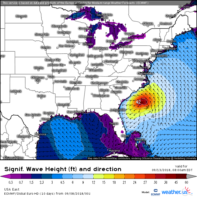
Regardless of Florence’s eventual track, and even if the storm by some last minute good fortune ends up avoiding the coastline (it’s possible, but definitely don’t be banking on it!), the one guaranteed significant impact will be large swells and rip currents. The storm will send these swells to the entire East Coast, from Florida to Maine. Impacts will include dangerous rip currents, beach erosion, and splashover. If you’re near the ocean, even hundreds of miles from the storm (looking at you, New England!), be aware of your surroundings and stay far away from the water’s edge.
The overall message of tonight’s update differs little from that of last night’s. Florence will track WNW while intensifying into a major hurricane over the next four days. By the middle of next week, the storm will be nearing the Southeast US coast as an extremely dangerous hurricane. Residents of coastal areas in SC and NC need to be preparing now for damaging winds, storm surge, and freshwater flooding. Residents of coastal VA and GA need to be on guard for impacts even though the core of the system isn’t currently forecast to make landfall in those areas. Residents of inland SC/NC/VA need to be preparing now for a potentially very serious inland flooding event, if current forecast ideas end up panning out.
Please consult with the National Hurricane Center for official forecast information, and stay updated through the next few days. Heed any and all advice from state and local officials, and local NWS offices, including any evacuation orders that might be issued.