
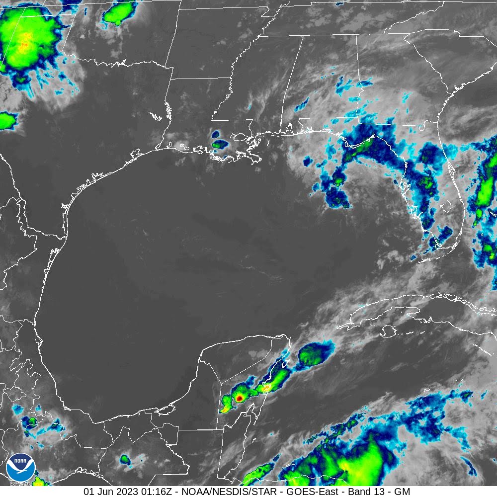

A low-pressure system that was expected to leave the Gulf of Mexico this weekend has slowed down, extending its stay.
In an announcement Wednesday, the National Hurricane Center gave the system a 20% chance of becoming a tropical cyclone in the next two to seven days. The system formed Tuesday from a grouping of thunderstorms and rain showers.
UPDATE FROM THE NATIONAL HURRICANE CENTER:
“Eastern Gulf of Mexico (AL91): An area of low pressure over the eastern Gulf of Mexico is producing disorganized showers and thunderstorms mainly to the northeast of the center. Environmental conditions appear marginally favorable for some slow development over the next day or two as the system meanders over the eastern or northeastern Gulf of Mexico. However, by this weekend environmental conditions are forecast to become unfavorable for additional development as the system drifts southeastward towards the Florida Peninsula. Regardless of development, the system could produce heavy rainfall and gusty winds over portions of the Florida Peninsula through this weekend. An Air Force Reserve Hurricane Hunter aircraft is scheduled to investigate the system on Thursday, if necessary. Additional information on the rainfall and flooding potential can be found in products issued by your local National Weather Service forecast office and Excessive Rainfall Outlooks issued by the Weather Prediction Center. * Formation chance through 48 hours…low…20 percent. * Formation chance through 7 days…low…20 percent.”

The shaded area in the above graphic is not a track, but an area of potential development for a tropical cyclone. NHC meteorologists create tracks only for named storms.
The system is expected to bring heavy rain to the Florida Coast and surrounding waters and will bring rain and wind gusts to Florida as it moves east.
This system has the potential to be the second Atlantic cyclone this year. The first, surprisingly, happened in January. The NHC, after reviewing a low-pressure system, discovered that it satisfied the conditions to be a cyclone, despite being months outside the usual hurricane season.
For the Gulf Coast, very little impact from the system is expected. There’s a 30% chance for thunderstorms Thursday from the afternoon into the early evening, and the National Weather Service predicts less than a tenth of an inch of rainfall.
No more rain is expected through the weekend, but there will be a slight chance for rain early next week.
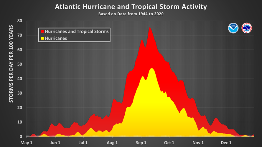
Going into this season, the region is coming off the tail end of a La Niña cycle. The El Niño-Southern Oscillation System impacts how much wind shear occurs over the Atlantic Ocean, and shear helps to break up hurricanes. After an unusually long three-year La Niña, which tends to promote more hurricanes in the Atlantic Ocean, current conditions are considered neutral.
During El Niño, higher wind shear in the Atlantic makes hurricanes less likely to form. These conditions have a better than 80% chance of coming back by July, with the National Oceanic and Atmospheric Administration. El Niño has also been factored into NOAA’s prediction of a roughly normal hurricane season, with up to 17 named storms, five to nine hurricanes, and one to four major hurricanes.
If El Niño does come back, it’ll likely be in place when the chance for hurricanes forming in the Atlantic is the highest, from August through November.
If the system currently in the Gulf becomes a tropical cyclone, it will be the first named storm, Arlene. Future named storms will be Bret, Cindy, Don, and Emily.