
As expected, latest model guidance has shifted yet again. This is going to keep on happening until we get closer to landfall, so it is important that you don’t focus solely on one model run or an outlier. We are monitoring it very carefully #Dorian


"Precision Tracking for Peace of Mind"

Hurricane Dorian ate some dry air overnight and that limited the amount of intensification. As the storm continues to drift NW it will eventually find an area of reduced shear and higher humidity and intensification will continue.
Current stats:
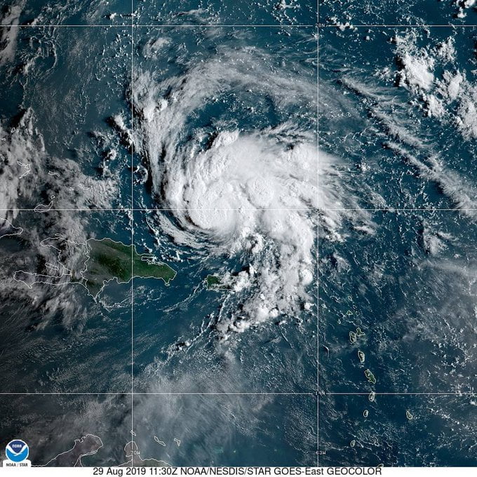
SUMMARY OF 500 AM AST…0900 UTC…INFORMATION
———————————————-
LOCATION…20.5N 66.6W
ABOUT 150 MI…240 KM NNW OF SAN JUAN PUERTO RICO
ABOUT 425 MI…685 KM ESE OF THE SOUTHEASTERN BAHAMAS
MAXIMUM SUSTAINED WINDS…85 MPH…140 KM/H
PRESENT MOVEMENT…NW OR 325 DEGREES AT 13 MPH…20 KM/H
MINIMUM CENTRAL PRESSURE…991 MB…29.27 INCHES
At 500 AM AST (0900 UTC), the center of Hurricane Dorian was located near latitude 20.5 North, longitude 66.6 West. Dorian is moving
toward the northwest near 13 mph (20 km/h), and this general motion is expected to continue through Friday. A west-northwestward motion is forecast to begin Friday night and continue into the weekend. On this track, Dorian should move over the Atlantic well east of the southeastern and central Bahamas today and on Friday, and approach the northwestern Bahamas on Saturday.

Maximum sustained winds are near 85 mph (140 km/h) with higher gusts. Strengthening is forecast during the next few days, and Dorian is expected to become a major hurricane on Friday.
Hurricane-force winds extend outward up to 15 miles (30 km) from the center, and tropical-storm-force winds extend outward up to 90 miles (150 km).
The minimum central pressure based on earlier Air Force Reserve Hurricane Hunter data is 991 mb (29.27 inches).
Hurricane Dorian Discussion Number 20
NWS National Hurricane Center Miami FL AL052019
500 AM AST Thu Aug 29 2019
Soon after the previous advisory was issued, Dorian appeared to have a bit of a hiccup in its structure. A dry slot was noted penetrating into the southeastern portion of the circulation, with the eye becoming cloud- and rain-filled. In fact, dropsonde data from the Air Force Reserve mission indicated that the central pressure had come back up a bit to around 991 mb. That being said, the plane still measured maximum SFMR winds between 70-75 kt, so the initial intensity is being held steady at 75 kt for this advisory.
Dorian continues northwestward, or 325 degrees at 11 kt. Confidence in the track forecast is fairly high for the first 48 hours, with Dorian expected to continue moving northwestward and then begin to turn west-northwestward between mid-level ridging to the north and a mid- to upper-level low retrograding westward across the Straits of Florida. The models, and their ensembles, continue to diverge after 48 hours and have not really budged from their respective solutions compared to yesterday. The GFS is a northern outlier from the rest of the guidance, showing a weaker ridge and bringing Dorian close to the Florida/Georgia border, while the UKMET and ECMWF models show stronger ridges and remain the southernmost solutions near South Florida. Given the spread in the guidance, the new NHC forecast blends the previous forecast with the simple multi-model consensus aids and the HCCA and Florida State Superensemble aids, and it actually ends up in a position very close to the tightly clustered global model ensemble means. The most notable change in the new forecast is that it’s a little bit slower than the previous one as Dorian approaches Florida.
Various shear analyses are indicating 10-15 kt of southwesterly shear over Dorian at the moment, but the global models show this shear diminishing within 12-24 hours. With lower shear and very warm waters, all of the intensity models forecast Dorian to begin strengthening again soon, and rapid intensification could occur. The updated NHC intensity forecast has been increased from the previous one and most closely follows the HCCA and Florida State Superensemble aids during the first day or two. After 48 hours, the official forecast is near or just above the intensity consensus, but it’s still lower than the solutions shown by the HCCA, Florida State Superensemble, and the HWRF. Dorian is likely to reach major hurricane strength in the next day or two and is forecast to maintain that status until it reaches land.
There are a lot of great follows on Twitter full of good information about this storm.
Ashley Ruiz@AshleyRuizWxAs expected, latest model guidance has shifted yet again. This is going to keep on happening until we get closer to landfall, so it is important that you don’t focus solely on one model run or an outlier. We are monitoring it very carefully #Dorian
Brad Panovich✔@wxbrad
This morning the guidance is really coming into consensus and honestly the last several runs for a significant impact on Florida from #Dorian. Rapid intensification is possible to Cat 4.
Ed Piotrowski✔@EdPiotrowski
Ryan Maue✔@RyanMaue
I’m concerned that Hurricane #Dorian could move west even more slowly than forecast.
The entire FL peninsula from Miami to Jax should still be prepared for an erratic track … and very intense Cat 3+
But the best follow on Twitter about this storm will always be the NHC.
National Hurricane Center✔@NHC_Atlantic

I’m still predicting a major hurricane as it approaches the Florida peninsula after that a big trough from the mid-Gulf coastal region will pick it up and take the hurricane to the north and northeast. I still think that this is not an issue for the northern coast. But we still need to not let our guard down and continue to watch the latest weather updates.
NORTHERN GULF COAST WEEKEND FORECAST:
A very slow-moving cold front is currently along the Miss River this morning and continues moving southwest. North of this boundary, around 80-degree dew pts are being replaced with lower 70 dew pts. South of this boundary, locations continue to be in the muggy around 80 dew pts.
The boundary will stall somewhere in the vicinity of the coast while dry air should remain over the entire area through at least Friday. A weak broad sfc low will move toward south FL today and then westward into the central gulf through the end of the week.
This feature is what helps bring the deep moisture back. Saturday looks like a transition day as moisture begins to move back into the area. It will take quite a bit to force the dry air back toward the west so that it can take its place. Sunday, the moisture should be in place over the area so afternoon Thunderstorms are back in the forecast.
#Dorian continues to move along the forecast track provided by the Hurricane Center. The end of the forecast track has it over central FL by 8pm Mon. The end of this forecast is subject to change with time. But what is noticed is a trend for all models to slow the system quite a bit as it approaches the SE US.
This usually means one of two things. Either the hurricane is beginning its turn or all steering currents have weakened and the system gets blocked. And either of these is not good for the SE states.
We will continue to watch trends and observe exactly what Dorian wants to do as it approaches the SE. It is simply too early to tell whether our area will receive impacts from this system.
But before we all go into this holiday weekend, it would be a good idea to keep up with the latest on what is happening with Dorian.


New Model coming out!!! Yes, it looks like the Hurricane Track would take it into the Gulf but Hang on!!! We have a trough that will pick up the Hurricane and bring it up the east Atlantic Coast and Northeast out to sea. I give this about 80 percent and the Gulf about 20 percent. Please Note: A Strong or Major Hurricane tends to move more North and a weaker Hurricane tends to move more west. With that being said I feel this will be a Cat 3 or even 4 Hurricane. Please keep up to date with the latest by going to


