
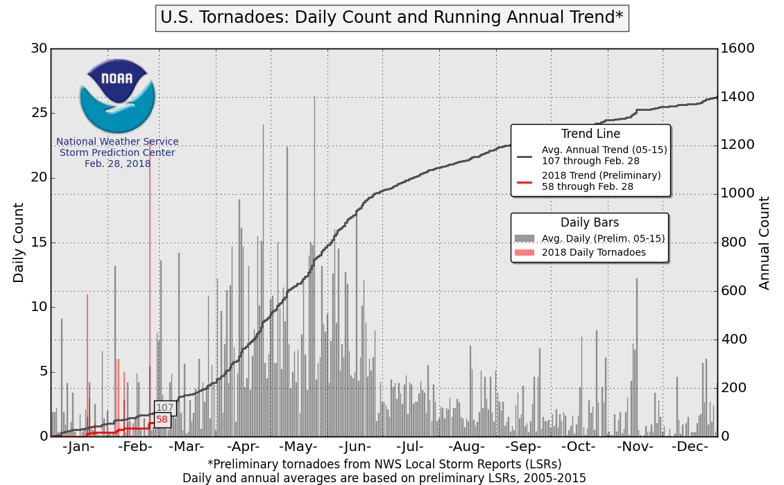
The United States is running behind schedule in the tornado numbers department this year. Will the quiet trend we have seen thus far continue as we head into April, and May? We might see a few strong Thunderstorms towards the end of this week but nothing too severe.
(Storm Prediction Center)
Looking out into April and May, the more predictable El Niño-Southern Oscillation (ENSO), Pacific Decadal Oscillation (PDO), and Atlantic Multidecadal Oscillation (AMO) indices provide a better look at how things might work out for the remaining two-thirds of spring.
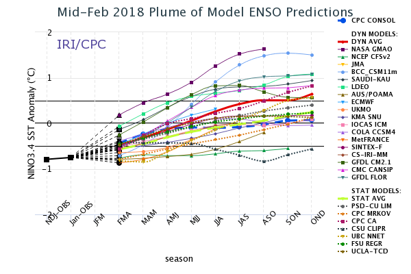
As the extreme blocking pattern relaxes, will La Niña make a grand return to being the main driver of April and May weather?
The La Niña provides a decent background state of the atmosphere, but we need more than that to make a forecast! Let’s take a look at the PDO and AMO.
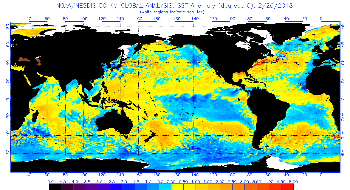
The AMO is fairly positive at the moment, which can be seen in the yellows, oranges, and reds in the Gulf of Mexico and the western and central Atlantic in the image above. The PDO was somewhat positive through most of the winter, which helped cause California to be drier than normal. However, the past couple of weeks have dropped sea surface temperatures along the West Coast as seen by the more prominent blue (cooler) anomalies along the West Coast, indicating that the PDO is becoming more neutral.
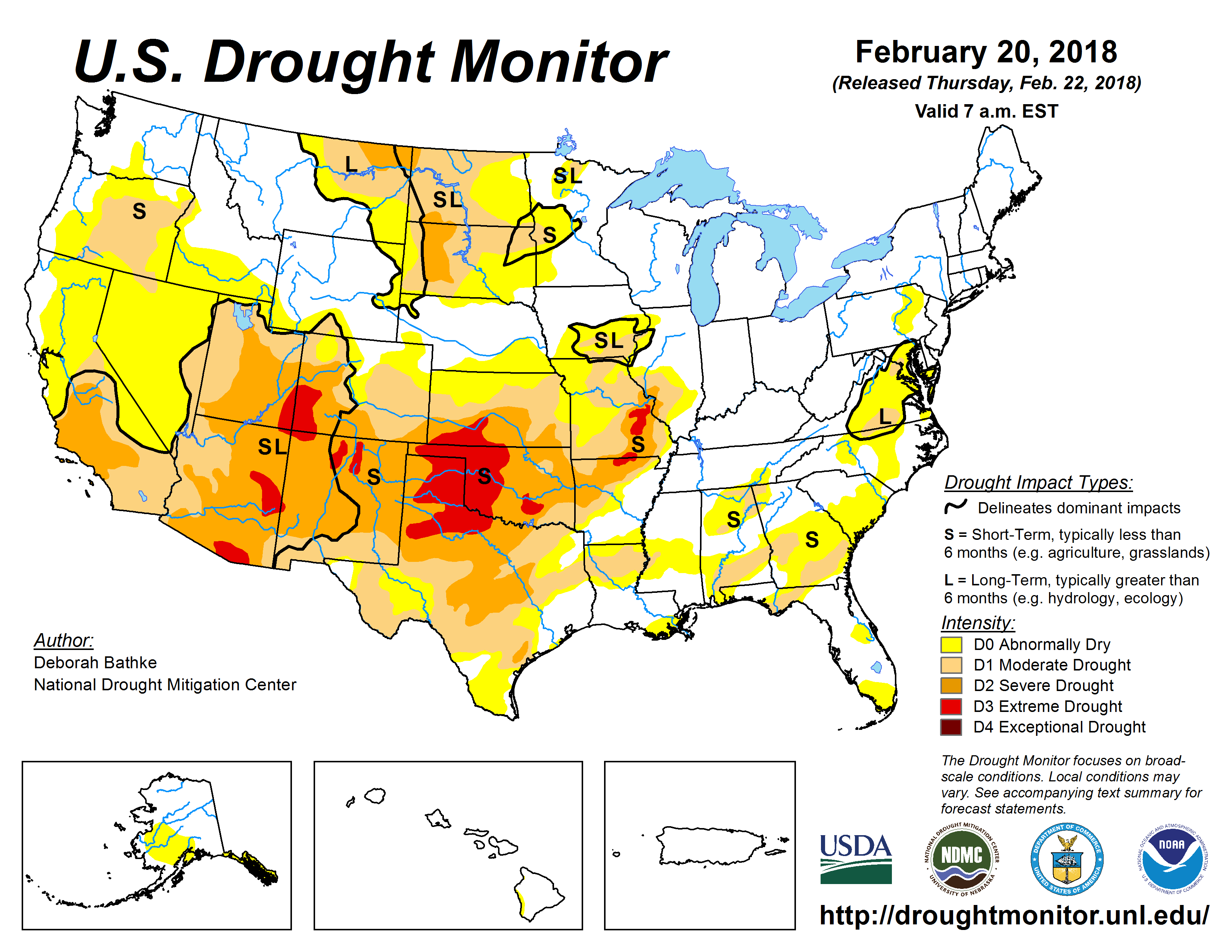
Checking in on the current drought conditions across the country, there are notable drought conditions in the Southwest and much of the Plains.
Drought can help create warmer and drier than normal conditions, which brings about greater dewpoint depressions at the surface, and thus higher cloud bases. The higher the cloud base, the harder it is for a circulation to reach the ground to become a tornado. While not as extreme as the drought in 2014, the current drought does cover much of the same region. The drought helped contribute to 2014’s below normal spring tornado count.
So what do we get with a borderline moderate La Niña, a positive AMO, and drought conditions in the Southwest?
Weighing the current conditions and analogs based on several long-range predictors, here is a look at the potential overall pattern from March through May:
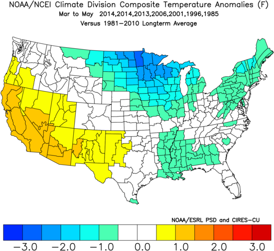
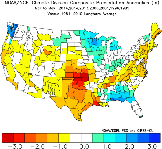
The pattern above generally favors a more active tornado pattern in the Mississippi Valley and the Southeast, while the more classic chase territory of the central and southern Plains could certainly end up quieter than normal.
Bottom line…
While most March and April analogs favored a quieter than normal conditions, 2006 was a notably active exception. Heading into May, the tornado count was normal to below normal. April has the potential for higher than normal tornado activity, but whatever gains that might occur in April could get wiped out by a quieter than normal May.
So what’s to stop this from being a more explosive year like 2008 or 2011? One major factor is the PDO, which although seems to be trending more neutral at the moment, has generally been positive in recent months. The PDO was firmly negative in 2008 and 2001 throughout the winter and spring months, which allowed storms to take a more favorable path across the southern U.S. instead of having to drop in from the Northwest like many storms in a +PDO regime do. However, if we do end up with a more persistent -PNA pattern that allows more storms to dig into the Southwest and brings more Gulf moisture into the central and eastern U.S., late March through May could become a more prolific tornado producer.
Odds of the tornado count ending up below/near/above the normal of 511 tornadoes (1991-2010 average) for meteorological spring:
Below normal: 35% (less than 460 tornadoes)
Near normal: 50% (between 460 and 550 tornadoes)
Above normal: 15% (above 550 tornadoes)
The following two tabs change content below.