| Hattiesburg/Pine Belt Area 
High Temperature | Location | Normal | Warmest Years | Coldest Years |
|---|
Hattiesburg | 60.5°F | 80°F (2015)
80°F (1955)
79°F (2016)
79°F (1974)
78°F (1987)
78°F (1982) | 26°F (1983)
34°F (1989)
38°F (2004)
38°F (1990)
39°F (1998/1993) |
Low Temperature | Location | Normal | Warmest Years | Coldest Years |
|---|
| Hattiesburg | 38.6°F | 74°F (2015)
68°F (1982)
65°F (1974)
64°F (1987)
61°F (1964) | 7°F (1989)
9°F (1983)
19°F (1966)
23°F (2013)
24°F (1990/1976/1968) |

| Location | Wettest Years | Years With Measurable
Precipitation/Total Years |
|---|
| Hattiesburg | 1.75″ (1988)
1.55″ (1952)
1.18″ (2012)
0.94″ (1973)
0.90″ (1981) | 22/69
(32%) |

- 1973 – Heavy rains caused flooding across portions of central and south Mississippi. In Laurel, around 600 people had to be evacuated due to rising waters. Damage was estimated around $350,000. In Hattiesburg, over 200 people were evacuated.
- 1983 – Extreme cold gripped the Deep South. Four people died in the state of Mississippi as a result of exposure.
- 1989 – A cold wave affected the Deep South, with the coldest air occurring during the days leading up to Christmas. The low temperatures caused water lines to freeze and break across the area.
- 2012 – A severe weather outbreak affected the Pine Belt. An EF-3 tornado tracked 61 miles from Pearl River County through northwestern Stone County, southern Forrest County, Perry County, into western Greene County. 12 were injured, 4 of them near Maxie in Forrest County. Additional tornadoes were reported including an EF-2 that tracked just north of Monticello in Lawrence County injuring 7, and an EF-1 that tracked through Ovett in Jones County.

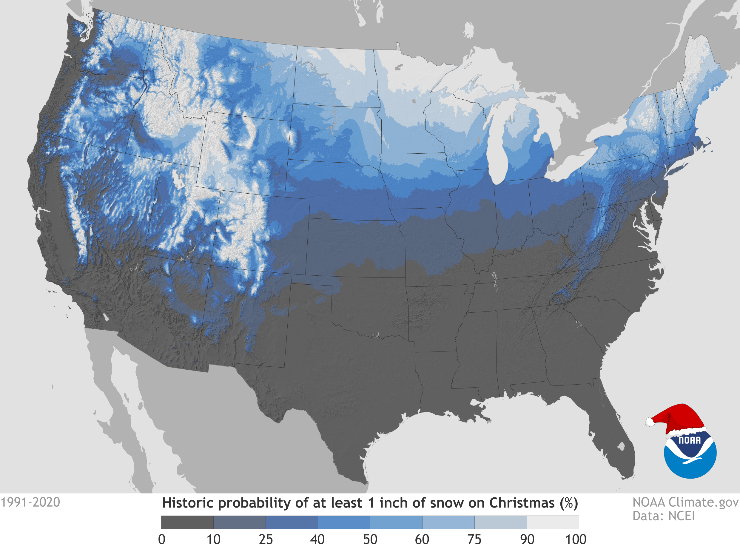
It goes without saying, the probability of experiencing a White Christmas in southeast Mississippi is very, very, very low. However, some of the Pine Belt area has seen at least one White Christmas over the last century. The map below from the National Climatic Data Center shows the probability of seeing a White Christmas based on past Christmas weather conditions. To qualify as an official White Christmas the snow depth must be at least one inch on Christmas Day. The snowfall does not necessarily need to occur on Christmas Day. 
Below is a listing a past White Christmases and other close calls. - 1929 – 2 to 7 inches of snow fell across Southeast Mississippi between December 21st and 23rd, including 7″ at Monticello, 5″ at Collins, 3″ at Laurel, and 2.5″ at Hattiesburg. Across much of the area, cold temperatures in the following days allowed snow to hang around through Christmas Day. Monticello reported a snow depth of 2″ on the evening of the 25th, while Laurel reported an inch on Christmas morning.
- 1963 – Light snow fell on the 23rd and 24th, bringing trace accumulations in a few areas of southeast Mississippi. There are no official reports of snow on the ground around the area on Christmas Day, but there might have been patchy snow on the ground Christmas morning, especially across northern parts of the region.
- 2010 – There was no official White Christmas in southeast Mississippi, but some locations experienced brief periods of snow flurries.
|


