09/13/2018/
Hello everyone!
Hurricane Florence is on final approach to North Carolina today. By the time tonight arrives, the storm will be just a few miles offshore, likely preparing to make landfall. As of this morning, the first outer bands of the storm are arriving on the Outer Banks, with conditions set to quickly begin deteriorating. Any preparations that haven’t already been taken care of should be rushed to completion! This blog will discuss some of the additional tweaks to Florence’s forecast, specifically the intensity forecast, but will primarily focus on the tools we have available at weather.us and weathermodels.com to track the storm in the coming days. As we get closer to actual landfall/impacts, the emphasis shifts from forecast models to observations. We’ve explored tons of our model resources in recent days, now it’s time to take a look at what we have observations wise.
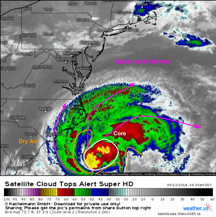
GOES-East satellite imagery (click here for a tutorial on how to use/interpret satellite imagery) is one of our best tools to monitor weather systems in near-real time. Now that Florence is close to the US, we’ll get new overview (Florence + surroundings) images every 5 minutes, and new closeup (just Florence) images every 1 minute. You can find both types of imagery at weather.us, just use the menus to the left of the image to toggle back and forth depending on your needs/interests. In terms of storm structure, Florence has become slightly less organized since yesterday, but remains a powerful hurricane with the core easily visible, albeit somewhat disrupted. Outflow is excellent to the north, but absence of outflow to the south/southeast indicates some south/southeasterly wind shear. This shear, combined with some lingering dry air visible in the image above, is what has caused Florence to slip a little in intensity. However, it’s extremely important to note that this changes very little in terms of the impact forecast for the Carolinas.
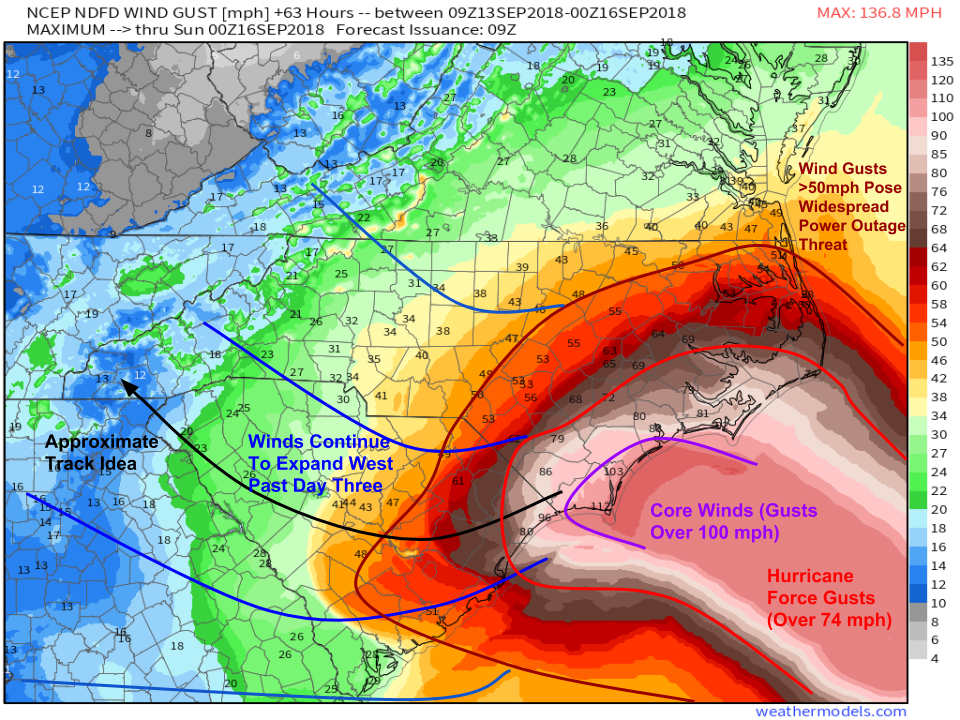
The only aspect of the forecast that Florence’s decreasing max winds will impact is, perhaps unsurprisingly, the wind forecast. We’re no longer forecasting winds of 120-130 mph at landfall. However, the core’s max winds were only ever forecast to impact a small part of the coast. That part of the coast, near Jacksonville and Wilmington, is still forecast to see very high winds in excess of 100 mph, which will still cause extensive damage. For areas farther from the core, wind impacts are actually likely to increase. Florence hasn’t actually weakened much if at all from a total energy perspective, it’s just spread that energy out over a wider area. Instead of a compact 25 mile wide core with winds that top out at 150 mph, the storm now has hurricane force winds that extend 70 miles from the center. This means that for areas away from the immediate track, the changes in Florence’s structure have actually increased the risk for wind-related impacts. This is especially true in Eastern NC just up the coast from the landfall point.
It’s also important to remember that you don’t need hurricane force (>74 mph) winds to cause damage. A good benchmark for a serious/widespread risk of power outages is usually around 50 mph. As the map above shows, nearly all of Eastern NC is forecast to see wind gusts of at least 50 mph. Also note that this map only includes winds between now and Saturday evening. Values are low in places like Western NC and SC not because something has changed in the overall forecast, but instead because the storm just hasn’t gotten there yet in that particular forecast map.
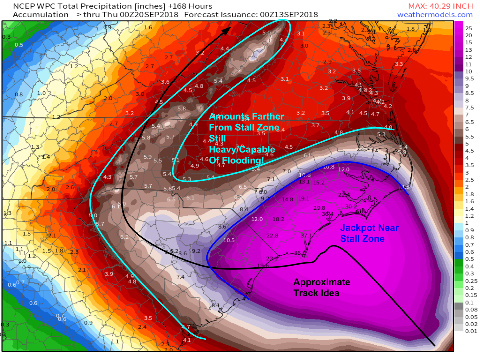
The rainfall forecast remains very similar to yesterday. The highest totals will be found in SE NC and NE SC, near where Florence slows to a crawl/stalls tomorrow. Totals here will very likely exceed 20″ with some localized totals to 40″ possible. As the storm begins moving again this weekend, totals won’t be quite so astronomical to the west in SC/W NC, but it doesn’t take 20″ to cause issues with flooding! As the storm then traverses the Appalachian Mountain range next week, watch for upslope enhancement to produce a flash flooding threat on SE facing mountain slopes.
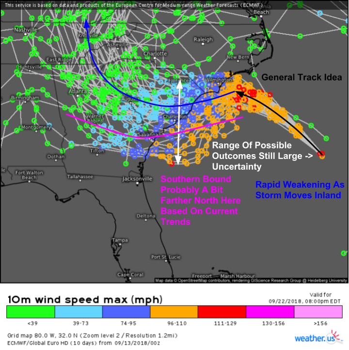
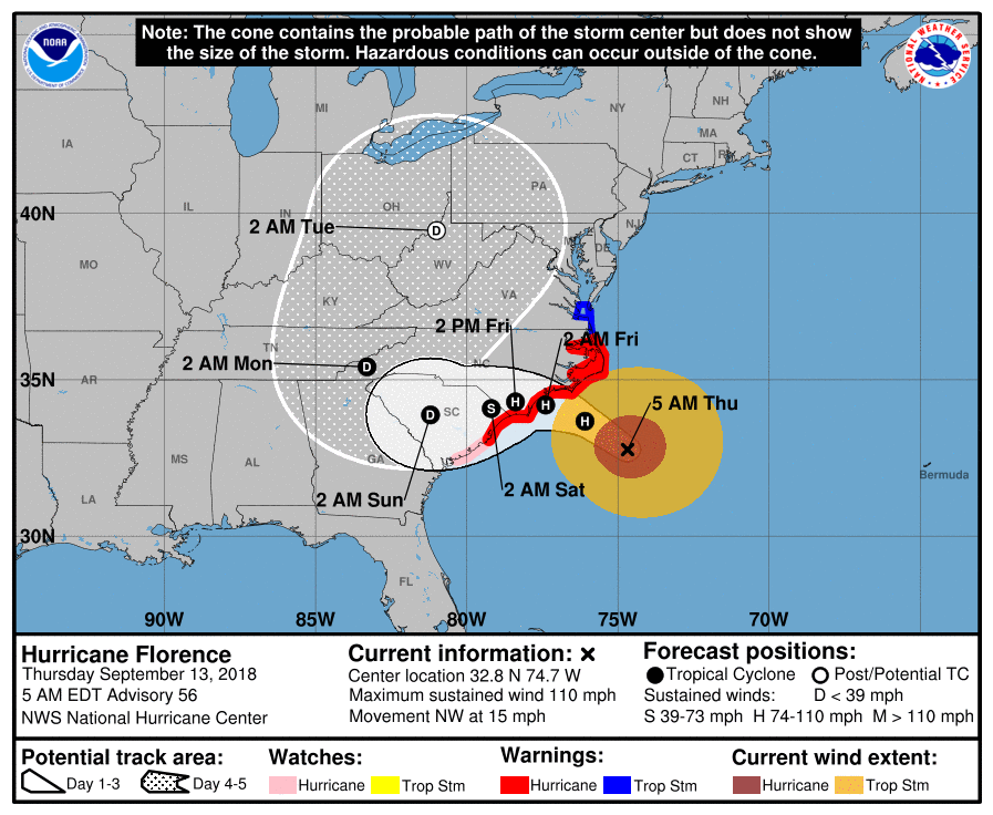
Checking in quickly on the EPS’s track predictions (click here for a video tutorial on how to use/interpret EPS track products), we’re looking at basically the same situation as we saw in yesterday’s forecast. NW movement to the NC coast will slow to basically zero tomorrow, at which point a slow drift WSW will begin. The storm is tracking a bit NE of forecast points this morning, judging by satellite imagery, so we can probably rule out some of the aggressively southern solutions that take the storm into GA after moving >100 miles back offshore. However, there is still a sizeable range of possible outcomes with how that WSW motion ends up evolving, so know that uncertainty does remain in that part of the forecast. Impacts wise, that really only matters for precise focusing of the axis of heaviest rain and highest winds. The overall impacts to Western NC and SC remain on track with inland flooding from heavy rain being the primary threat, and power outages from TS force wind gusts being another thing to keep an eye on.
Another impact to be concerned with today in Eastern NC will be tornadoes. Hurricanes are good at producing tornadoes in their outer bands because of the warm, moist, and unstable atmosphere they bring, combined with the rotational energy present as a result of the storm’s circulation spinning in different directions with height. At low levels, air swirls counter-clockwise towards the center. In the upper levels, air swirls clockwise away from the center (that’s the outflow/venting we’ve been talking about). This shift in wind direction with height is known as wind shear, which is an essential ingredient for tornadoes. The map above is one way to measure that rotational energy. You’ll notice maxima just ahead of Florence’s rain bands on the north side of the storm, which is where the greatest threat will be (SE NC).
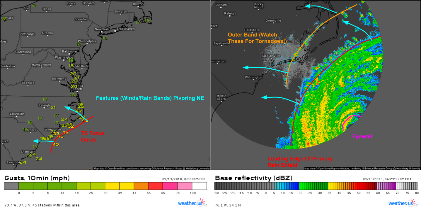
So besides the GOES-East imagery we’ve been watching all week, how can you follow along with Florence’s progress over the next few days? Shown above are two of your many options. The map on the left is observed wind gusts, which will update every hour (not automatically though, you need to press the refresh button at the top left of the map to get the latest data). The map on the right updates every 3-5 minutes, and is our HD radar product. It will let you keep tabs on the evolution of the storm’s movement and structure. For longer range data (to see farther offshore), use the “SD” option which sacrifices some resolution to be able to see farther out.
You can put the radar in motion using the “play” button, and you can extend the animations with the “clock +” button. Radar can seem complicated at first, but it’s fairly easy to interpret. Basically, the farther up you go on the scale, the heavier the rain is (for this storm, that’s not always the case). You can see the lighter rain between bands, then the maxima in values in the bands and in the eyewall.
I’ll be covering the storm all day on twitter @WeatherdotUS and @JackSillin. Also be sure to follow @RyanMaueand @Kachelmann for additional updates/perspectives.
I will be doing a periscope update this evening to update everyone on the storm. I’m currently planning on 7 PM. Tune in to hear the latest, see our storm tracking tools in action, and ask any questions you may have about the storm.
As a reminder, all official information for Florence including watch/warning info comes from the National Hurricane Center. Posts such as these do not exist as a substitute for their forecasts, they exist to add some additional context and explore some of the scientific processes behind the forecast. If you’re looking for info to make critical decisions, consult the official products. If you’re looking to peek “under the hood” of the forecast to see not just what’s happening, but why, you’ve found the right spot.
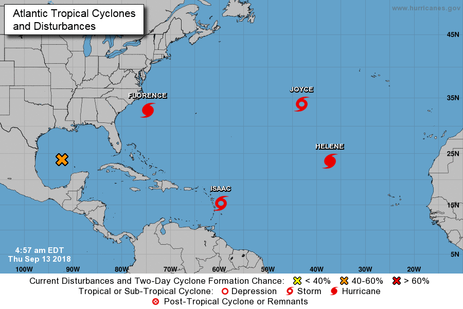
As one last note, Florence is not the only storm active in the Atlantic today. We have another hurricane, Helene, two tropical storms, Isaac and Joyce, and a disturbance that hasn’t developed yet, but could. Helene will impact the Azores and Europe, so I won’t cover it here. Joyce won’t impact land, so I won’t cover it here either. Depending on time today, I may take a look at the Gulf of Mexico disturbance as it will bring heavy rains to Texas, and could develop into a TD or weak TS before then. Isaac will impact the Lesser Antilles today, and could pose a long range threat to the Gulf of Mexico, but we’re a long way off from having to worry about it.
-Jack
