

BULLETIN
Tropical Depression Eleven Advisory Number 1
NWS National Hurricane Center Miami FL AL112018 1100 PM AST Fri Sep 21 2018 …TROPICAL DEPRESSION FORMS EAST OF THE WINDWARD ISLANDS… …FORECAST TO DISSIPATE WITHIN A FEW DAYS… SUMMARY OF 1100 PM AST…0300 UTC…INFORMATION LOCATION…13.1N 53.4W ABOUT 510 MI…825 KM E OF THE WINDWARD ISLANDS MAXIMUM SUSTAINED WINDS…35 MPH…55 KM/H PRESENT MOVEMENT…WNW OR 290 DEGREES AT 6 MPH…9 KM/H MINIMUM CENTRAL PRESSURE…1007 MB…29.74 INCHES
WATCHES AND WARNINGS —There are no coastal watches or warnings in effect. DISCUSSION AND OUTLOOK –At 1100 PM AST (0300 UTC), the center of Tropical Depression Eleven was located near latitude 13.1 North, longitude 53.4 West. The depression is moving toward the west-northwest near 6 mph (9 km/h), and this general motion will likely continue for the next couple of days. Maximum sustained winds are near 35 mph (55 km/h) with higher gusts. Little change in strength is expected for the next day or two. The depression is forecast to dissipate late this weekend or early next week before it reaches the Lesser Antilles. The estimated minimum central pressure is 1007 mb (29.74 inches).


Tropical Depression Eleven Discussion Number 1
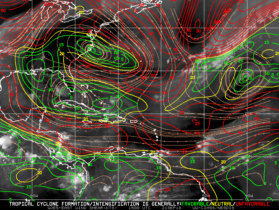
NWS National Hurricane Center Miami FL AL112018 1100 PM AST Fri Sep 21 2018 The small, but well-defined, low pressure system located about 500 miles east of the Lesser Antilles has been producing steady convection for the past several hours. Although this convection is displaced to the south and east of the exposed low-level center due to strong westerly wind shear, it has persisted long enough to meet the NHC definition of a tropical cyclone. On this basis, advisories are being initiated on Tropical Depression Eleven. The initial intensity is set at 30 kt based on ASCAT data from earlier today which showed a couple of 25-30 kt wind vectors in the northeast quadrant of the circulation.
The intensity guidance is in extremely good agreement that the depression is unlikely to strengthen. All of the global models forecast an increase in upper-level winds over the small cyclone during the next 24 h. In fact, SHIPS diagnostics indicate that the 850-200 mb shear could exceed 30 kt by tomorrow morning, and will be near 40 kt within 48 h. As a result of this shear and some dry air also in the vicinity, the dynamical models unanimously forecast dissipation within 72 h, and most show that the depression will open into a trough of low pressure sooner than that. The NHC forecast conservatively maintains the tropical cyclone for 48 h, but it could weaken and dissipate sooner than currently indicated.
The depression has recently been moving almost due west, but a longer-term motion yields an initial motion of 290/5 kt. A break in the subtropical ridge to the north of the depression should result in fairly weak steering flow for the next day or two, and only a slow west-northwestward to westward motion is anticipated. All of the typically-reliable track models are in fairly good agreement on this scenario. The NHC forecast is very close to HCCA at all forecast hours, and lies near the south edge of the tight guidance envelope.
Tropical Weather Outlook
NWS National Hurricane Center Miami FL 800 PM EDT Fri Sep 21 2018 For the North Atlantic…Caribbean Sea and the Gulf of Mexico:
1. A low pressure system is located about 600 miles south-southeast of the Cabo Verde Islands. Although the low is currently producing only limited shower and thunderstorm activity, the system appears to have become better organized since earlier today and a tropical depression could form during the next day or two. This system is expected to move westward at 15 to 20 mph across the low latitudes of the eastern and central tropical Atlantic Ocean through early next week.
* Formation chance through 48 hours…medium…40 percent.
* Formation chance through 5 days…medium…60 percent.
ECMWF MODEL RUN

GFS MODEL RUN


2. A well-defined low pressure system located about 400 miles east of the Windward Islands has produced persistent thunderstorms just east of its center for the past several hours. If current trends continue, advisories could be issued on a tropical depression later tonight or on Saturday. By late this weekend, strong upper-level winds and dry air are likely to prevent further development of this system while it moves west-northwestward to northwestward at around 10 mph.
* Formation chance through 48 hours…medium…60 percent.
* Formation chance through 5 days…medium…60 percent.
ECMWF MODEL RUN


3. A broad area of low pressure is located a little more than 150 miles southeast of Bermuda. This low is producing minimal shower activity, and little development is anticipated for the next day or two. However, environmental conditions could become more conducive for slow development by late this weekend or early next week when the system moves over the southwestern Atlantic Ocean.
* Formation chance through 48 hours…low…10 percent.
* Formation chance through 5 days…low…30 percent.
4. A non-tropical low pressure system is expected to develop early this weekend over the north-central Atlantic Ocean, midway between Bermuda and the Azores. Conditions are expected to be conducive for the low to acquire subtropical or tropical characteristics, and a subtropical or tropical cyclone is likely to form late this weekend or early next week while the low meanders over the central Atlantic Ocean.
* Formation chance through 48 hours…low…30 percent.
* Formation chance through 5 days…high…70 percent.
SHEAR MAP
STEERING MAP

SEA SURFACE TEMPS
