National Hurricane latest Update:
An area of showers and thunderstorms currently over the northwestern Caribbean Sea and adjacent land areas is expected to move west northwestward into the Bay of Campeche Saturday or Saturday night, where a low-pressure area could form. Subsequent slow development is possible on Sunday or Monday if the system remains offshore of the coast of Mexico. Regardless of development, locally heavy rains are possible over portions of Belize, Guatemala, and southeastern Mexico during the next few days.
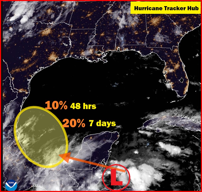
Overview of the Current Tropical System
As of the latest update from the National Hurricane Center, a tropical system is currently developing in the southwestern Gulf of America. This weather phenomenon has garnered attention due to its rapid formation and the potential impacts it may have on coastal communities and marine activities. The system is situated approximately 200 miles off the coast of southern Texas, moving in a northward direction at a speed of around 10 miles per hour.
The tropical system exhibits characteristics typical of developing storm systems, including organized convection and a well-defined circulation pattern. Maximum sustained winds are currently recorded at approximately 25 miles per hour, with higher gusts contributing to the overall intensity. Atmospheric pressure within the system continues to lower, indicating strengthening. These conditions are influenced by warm sea surface temperatures in the Gulf, which provide the necessary energy for the system’s growth and potential development into a more significant tropical disturbance.
Furthermore, the environmental conditions surrounding the area play a critical role in shaping the trajectory and intensity of the tropical system. Favorable wind shear patterns have been identified, allowing for the possibility of further intensification as the system interacts with the warm waters of the Gulf. Coastal residents should remain vigilant as forecasts indicate potential landfall within the next few days, primarily affecting areas along the Texas coastline.
Given the significance of this tropical system, it is essential to continue monitoring its developments. Emergency preparedness is advisable for those in the projected path, as the threat of heavy rainfall, storm surge, and hazardous winds may arise as the system matures and approaches land. Therefore, local authorities and citizens alike must stay informed through reliable updates to ensure safety during this evolving weather event.
Forecast and Predictions
The National Hurricane Center (NHC) has been closely monitoring the evolving tropical system in the Southwestern Gulf of America. As the storm progresses, the NHC is dedicated to providing updates on the forecasted path, potential intensification, and anticipated weather impacts. Currently, computer models suggest several possible pathways for the system, with the most likely trajectory veering towards the northern regions of the Gulf, potentially impacting coastal areas over the next few days.
As part of their analysis, meteorologists consider multiple factors that can influence the storm’s behavior. These include sea surface temperatures, atmospheric conditions, and the prevailing wind patterns that may either promote or inhibit the tropical system’s development. Warmer sea surface temperatures can contribute to the intensification of the storm as they provide the necessary heat and moisture that fuels tropical systems. Meanwhile, atmospheric wind shear can either enhance or disrupt the organization of the storm, crucially affecting its forecasted intensity.
The NHC utilizes a variety of models to predict the future intensity of the tropical system. These models range from statistical approaches that analyze historical data to dynamic models that simulate the physical processes of the atmosphere. Given the current conditions, there is an increased likelihood that the system may strengthen into a more organized tropical storm or even a hurricane, depending on continued environmental support and the timing of its landfall.
In terms of expected weather impacts, residents along the potential paths of this tropical system should prepare for heavy rainfall, strong winds, and possible storm surges. Forecast updates will continue to be critical as the situation evolves, and residents are advised to remain vigilant and stay informed through official channels such as the NHC.
Impact and Preparedness Advice
The recent tropical system developing in the southwestern Gulf of America poses significant risks to both coastal communities and inland regions. Based on current predictions by the National Hurricane Center, residents can expect a variety of weather effects, including heavy rainfall, strong winds, and potential storm surges. Heavy rainfall is particularly concerning, as it may lead to flash flooding, making travel hazardous and affecting local infrastructure. Coastal areas might experience intense wind gusts capable of uprooting trees, damaging homes, and disrupting power supply. Furthermore, storm surges can inundate low-lying areas, potentially causing extensive property damage and threatening public safety.
In light of these potential impacts, it is crucial for residents in affected areas to take proactive measures to prepare for the upcoming tropical system. First and foremost, individuals should stay informed about the latest updates from the National Hurricane Center and local authorities. Creating an emergency kit is essential; it should include necessities such as non-perishable food, water, flashlights, batteries, medications, and first-aid supplies. Residents should also take the time to understand their community’s evacuation routes and have a plan in place should evacuation become necessary.
As conditions worsen, maintaining a reliable communication channel is vital. Keeping a battery-operated radio on hand will allow residents to receive critical information even during power outages. Additionally, consider reinforcing windows and doors to lessen wind damage. If you reside in a flood-prone area, it may be wise to relocate valuables to higher ground as a preventive measure. Local emergency services and resources such as shelters should also be researched and familiarized with before the storm strikes. By prioritizing preparedness and safety, residents can better weather the challenges posed by this tropical system.
Follow-Up and Ongoing Monitoring
The continuous monitoring of tropical systems is crucial for understanding their development and potential impact. The National Hurricane Center (NHC), along with other meteorological organizations, plays a pivotal role in observing weather patterns and disseminating updates about tropical systems, particularly in the Southwestern Gulf of America. The NHC utilizes advanced satellite imagery, radar data, and weather models to provide real-time assessments of these systems, ensuring that the public receives timely and accurate information.
Updates regarding the tropical system will be communicated through various channels. The NHC regularly issues advisories, forecasts, and discussion bulletins that are made available online, via mobile apps, and through social media platforms. These channels serve as essential resources for anyone seeking information on the latest developments, as they offer detailed insights into the storm’s trajectory, intensity, and any potential hazards it may pose. Trustworthy information is critical in enabling communities to understand the risks involved and to prepare accordingly.
Staying informed through these reliable sources is vital, as tropical systems can change rapidly. It is advisable for individuals and families to closely monitor these updates and to approach disaster preparedness proactively. Preparedness involves not only having an emergency kit and an evacuation plan but also staying connected to local authorities and news sources that provide updates on the evolving situation. Engagement with community resources can enhance one’s readiness and response to natural disasters. Individuals are encouraged to participate in local preparedness initiatives and to share relevant information within their communities, fostering a culture of safety and resilience. Continued vigilance and proactive measures are essential as we navigate the complexities of tropical systems.